 COUNTY
 COUNTY
|
|
||||||||
| EXISTING STATIONS | ||||||||
|---|---|---|---|---|---|---|---|---|
| Station Name |
Original Railroad | Current Location |
Type | Date Built |
Current Use |
Track Status |
Building Material |
More Info |
| Elysian |
 |
South side of Main Street between 3rd and 4th Streets (GPS: 44.198564, -93.678747) |
R | ???? | Civic | Gone | Brick | |
| Le Center |
 |
North side of East Ottawa Street between Cordova and Montgomery Avenues (GPS: 44.387208, -93.728379) |
C | ???? | Business | Gone | Wood |
|
| new prague |
 |
North side of Main Street West at 3rd Avenue NW (GPS: 44.544223, -93.582647) |
C | 1877 | Railroad | In Use | Wood | |
| STATIONS OF THE PAST | ||||||||
| Station Name |
Original Railroad |
Notes | ||||||
| Cleveland |
 |
|||||||
| Elysian |
 |
This station, built in 1887, was north of MN-60 between 1st and 3rd Streets. It was on the south side of the mainline with a siding to the south. The old flour mill was due SE. The station was closed in 1967. | ||||||
| Greenland |
 |
|||||||
| Henderson (East Henderson) (Rudolph) |
 |
This station was on Henderson Station Road (CR-34) about 1/4 mile south of MN-19. It was to the west of where the road turns from north/south to east/west. The station was built in 1867. This location is also known as Henderson Station. | ||||||
| Kasota |
 |
|||||||
| Kasota |
 AND  |
Joint station. | ||||||
| Kilkenny |
 |
The depot was just south of Oak Street on the west side of the tracks. | ||||||
| Le Center (LeSueur Center) |
 |
This station was on the north side of Ottawa Street between Montgomery and Cordova Avenues at GPS: 44.387224, -93.728598. | ||||||
| Le Sueur (Prairie La Fleche) (Wahinoge) |
 |
The first station here was between Oak and Maple Streets. | ||||||
| Le Sueur |
 |
This second-generation station was at the NW end of Oak Street at GPS: 44.464093, -93.914385. This may have been a new station or the old station with an addition as it was essentially at the smae location as the original station except larger. The station was either built or expanded sometime between 1896-1902. | ||||||
| Montogomery |
 |
This station was on the south side of Vine Street east of 1st Street at GPS: 44.438621, -93.580475. | ||||||
| Montogomery |
 |
This later-generation station replaced the original station listed above at the same location (south side of Vine Street). | ||||||
| Montgomery |
 |
This station was at the south end of 1st Street at what is now Milwaukee Avenue at GPS: 44.433207, -93.581128. | ||||||
| Mumford (Doyle) |
 |
|||||||
| Ottawa |
 |
The original St. Paul & Sioux City RR station here was built in 1867, but burned down on September 13, 1869 after being struck by lightning (Cleveland Plain Dealer, 09-14-1869). | ||||||
| ottawa |
 |
The station was on the east side of Ottawa Road south of Sumner Street. | ||||||
| St. Peter (East St. Peter) |
 |
This station was across the river in Le Sueur County. It was on the south side of East Broadway Avenue (MN-99). The depot site is vacant today, but the tracks are still active. The first station here was built in 1867 and later served as the freight station when a new station was built in 1905. | ||||||
| St. Peter (East St. Peter) |
 |
This was likely the first Omaha station. | ||||||
| Waterville |
 |
This line was the former Cannon Valley Branch of the M&St.L. It was purchased by the CGW 1899 and became the Mankato-Red Wing Branch of that line. At first the CGW used the M&St.L depot, but then built its own station in 1900. The station was on the SE corner of South 2nd Street and East Hoosac Street. There was also a branch line that ran on the north side of Lake Tetonka ending at the Tetonka Summer Resort Hotel and racetrack. | ||||||
| Waterville |
 |
This station was on the SE corner of West Hoosac Street and South Reed Street at GPS: 44.216509, -93.570554. It appears that a concrete block addition was made to the wood frame station in later years. | ||||||
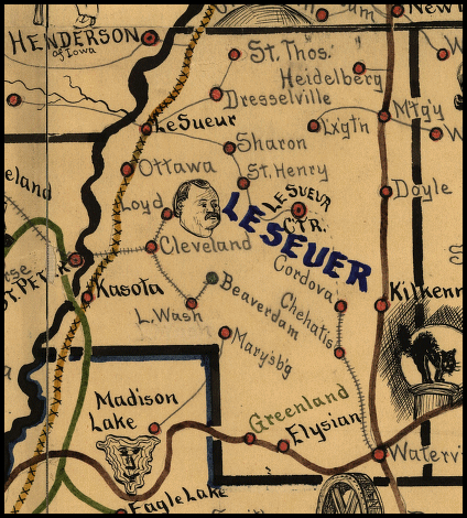
| 1898 LE SUEUR COUNTY RAILROAD MAP | ||||||||
 |
||||||||
|
Notes About Existing Stations... LeCenter (MILW) - Known formerly as Le Sueur Center, the name was subsequently changed to Le Center. This may be a modified remnant of the original station as it was at the same location (but the original station was larger - see listing for LeCenter below in the "Stations Of The Past" section). |
||||||||