 COUNTY
 COUNTY
|
|
||||||||
| EXISTING STATIONS | ||||||||
|---|---|---|---|---|---|---|---|---|
| Station Name |
Original Railroad | Current Location |
Type | Date Built |
Current Use |
Track Status |
Building Material |
More Info |
| Biscay |
 |
Nowthen Threshing Show Grounds, 7415 Old Viking Boulevard, Nowthen. | P | 1901 | Museum | None | Wood |
|
| STATIONS OF THE PAST | ||||||||
| Station Name |
Original Railroad |
Notes | ||||||
| Andover |
 |
According to the 1915 GN Vaulation Records, the station here was built in 1908 with the dimensions of 12'x34'. | ||||||
| Anoka |
 |
On maps from 1874, the original St.P&P station is shown just east of North 7th Avenue on the north side of the tracks at GPS: 45.205907, -93.377599. | ||||||
| Anoka |
 |
A new station was built here in 1887 at the same location as the original St.P&P station listed above. This station later served as a freight-only station for both the NP and GN. According to the NP Valuation Records for 1917, it measured 24'x115'. | ||||||
| Anoka |
 AND  |
According to the 1915 GN Valuation Reports, a new brick station was built here in 1892 and measured 26'x104'. This station was on the south side of the tracks off of Pierce Street at GPS: 45.205239, -93.376428. On later maps this station is marked as "Union Station" and the old NP station is labeled as the freight station. It was demolished in the 1980s. | ||||||
| Berlin |
 |
This was an early station between Fridley Station and Northtown Junction. This is part of Columbia Heights now. | ||||||
| Belt Line (Brighton) |
 |
Originally known as "Brighton" the station name was changed by the GN to "Belt Line Junction" in April 1908. A year later the GN shortened the name to "Belt Line." | ||||||
| Bethel |
 |
According to the 1915 GN Vaulation Records, the station here was built in 1899 with the dimensions of 30'x68'. The station was torn down in 1945 and the lumber was used to build a house. | ||||||
| Cedar |
 |
According to the 1915 GN Vaulation Records, the station here was built in 1908 with the dimensions of 12'x34'. | ||||||
| Columbia Heights |
 |
|||||||
| Columbia heights |
 |
|||||||
| Constance |
 |
|||||||
| Coon Creek
Junction (Eastern Crossing) |
 AND  |
According to the 1915 GN Vaulation Records, the station here was built in 1910 with the dimensions of 16'x49'. However, the revised GN Valuation Records from 1922 say that the station was built in 1895. The NP Valuation Records for 1917 don't list a station here, but do list depot assests, so the station was likely owned by the GN and shared by the NP. | ||||||
| Dayton (Itaska) (Worth) |
 AND  |
According to the 1915 GN Vaulation Records, the station here measured 20'x64'. The NP Valuation Records for 1917 don't list a station here, but do list depot assests, so the station was likely owned by the GN and shared by the NP. | ||||||
| Fridley (Belt Line JCT.) |
 |
According to the Northern Pacific Vaulation records of 1917, this station was built in 1892 and measured 8'x12'. | ||||||
| Fridley (Fridley Park) |
 |
|||||||
| Itaska Station |
 |
There was a GN station here on a siding track. This was near the Anoka/Sherburne County border near the lower SE corner of Sherburne County. The depot (and the spelling of "Itaska") is shown on Sherburne County maps from 1903. This would have been in the vicinity of Alpine Drive NW off US 169. | ||||||
| Northtown Junction |
 AND  |
This station was in section 34 of Fridley Township. It was where 33rd Street (now St. Anthony Parkway) crossed the tracks in the vicinity of GPS: 45.027370, -93.268860. The name of the station was changed from Northtown Junction to Northtown in 1909. | ||||||
| Powers Station |
 |
This station is shown on the 1914 atlas beween Anoka and Coon Creek Junction. It was in Anoka Township, Section 26. | ||||||
| Worth |
 |
This station is listed in the 2001 edition of Minnesota Place Names, but indicates that the location is unknown. | ||||||
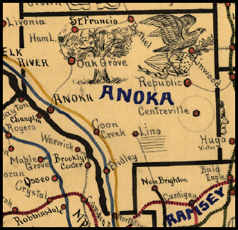
| 1898 ANOKA COUNTY RAILROAD MAP | ||||||||
 |
||||||||
|
Notes About Existing Stations... Biscay (CM&St.P) - Depot was moved to Nowthen Threshing Show Grounds from Biscay (McLeoad County) in 2001. |
||||||||