 COUNTYCOUNTY
|
|
||||||||
| EXISTING STATIONS | ||||||||
|---|---|---|---|---|---|---|---|---|
| Station Name |
Original Railroad | Current Location |
Type | Date Built |
Current Use |
Track Status |
Building Material |
More Info |
| Annandale |
 |
Pioneer Park on the south side of MN-55 (Elm Street East) between Lundeen
Drive and Norway Dive in Annandale. (GPS: 45.255439, -94.110983) |
C | 1886 | Museum | None | Wood |
|
| buffalo |
|
612 NE 3rd Avenue (NE end of Soo Line Avenue) (GPS: 45.178125, -93.872167) |
C | 1954 | Railroad | In Use | Brick | |
| clearwater |
 |
105 Elm Street (GPS: 45.420959, -94.048100) |
C | 1905 | Residence | None | Wood |
|
| Cokato |
|
651 Parker Aveune in Dassel
(Meeker Co.) (GPS: 45.081332, -94.315346) |
C | 1913 | Business | None | Wood | |
| montrose |
|
211 Buffalo Avenue North (GPS: 45.070895, -93.911893) |
C | ???? | Reataurant | None | Wood |
|
| STATIONS OF THE PAST | ||||||||
| Station Name |
Original Railroad |
Notes | ||||||
| Albertville (St. Michaels Sta.) (Hamburg) |
|
The station was south of School Lake. The station sat near where 61st Street NE is today in Albertville. According to the 1915 GN Valuation Records, the station standing at that time mesured 25'x61'. Originally called "Hamburg," the station name was changed to "St. Michaels Station" and then changed again to "Albertville" in April 1909. | ||||||
| Buffalo |
|
The original station here burned down on May 30, 1891. A new station was built shortly thereafter. | ||||||
| Buffalo |
|
The second station here served from 1891 until 1907 when it burned down. | ||||||
| Buffalo |
|
This station, built in 1907, burned down on November 30, 1953 when a Soo freight train crashed into the station (St. Cloud Times, 12-1-1953). A railroad car was used as a temporary station here until the new brick station (still standing) was built in 1954. Earlier stations here were located approximately where the current station is at the NE end of Soo Line Avenue (formerly Mill Road) on the SW side of the tracks at GPS: 45.178125, -93.872167. | ||||||
| Clearwater |
|
The first station here, according to 1896 maps, was on the corner of Maple and River Streets. According to the 1915 GN Valuation Records, the new station was built here in 1905 and mesured 30'x48'. | ||||||
| Cokato |
|
An earlier station was located on the north side of 2nd Street between Jackson and Broadway Streets on the south side of the tracks at GPS: 45.077372, -94.191678 (the same location as the later station). It was built in 1875. | ||||||
| Delano |
|
According to the 1915 GN Valuation Records, a new station was built here in 1885 and was remodeled/expanded in 1904. However, according to The Star Tribune (5-31-1882) a 20'x80' station was built here in 1882. The station was modernized in 1942 (Willmar Weekly Tribune 4-1-1942). The 1894 and 1899 maps show the station on the south side of the tracks at East Franklin and 2nd Street South at GPS: 45.040343, -93.787852. The 1909 and newer maps show the station on Railroad Avenue between 3rd Street North and 4th Street North at GPS: 45.040374, -93.785618, so it appears that the station was moved sometime between 1899-1909 (on the maps it appears to be the same building rather than a new station). It was torn down in 1988. | ||||||
| Dickinson Station |
|
This carbody station was between Rockford and Buffalo on the east side of Section 15 in Rockford Township. | ||||||
| Enfield (Silver Creek Siding) |
|
Called Silver Creek Siding until the name was officially changed by the GN to "Enfield" in December 1906. According to the 1915 GN Valuation Records, a new passenger station was built here in 1913 that mesured 8'x34'. Based on those measurements, that station was what appears in the photo as converted railroad carbody. The station was officially abandoned by the GN in July 1960. | ||||||
| Enfield |
|
According to the 1915 GN Valuation Records, a new freight station was built here in 1906 that mesured 8'x12'. It primarily handled dairy products. | ||||||
| Hanover |
|
|||||||
| Hasty |
|
According to the 1915 GN Valuation Records, a new station was built here in 1887 that mesured 20'x64'. | ||||||
| Howard Lake |
|
This is likely the earlier station that was located west of 11th Avenue. | ||||||
| Howard lake |
|
The station pictured was just north of US-12 on the lake. According to the 1915 GN Valuation Records, a new station was built here in 1906 that mesured 30'x68'. | ||||||
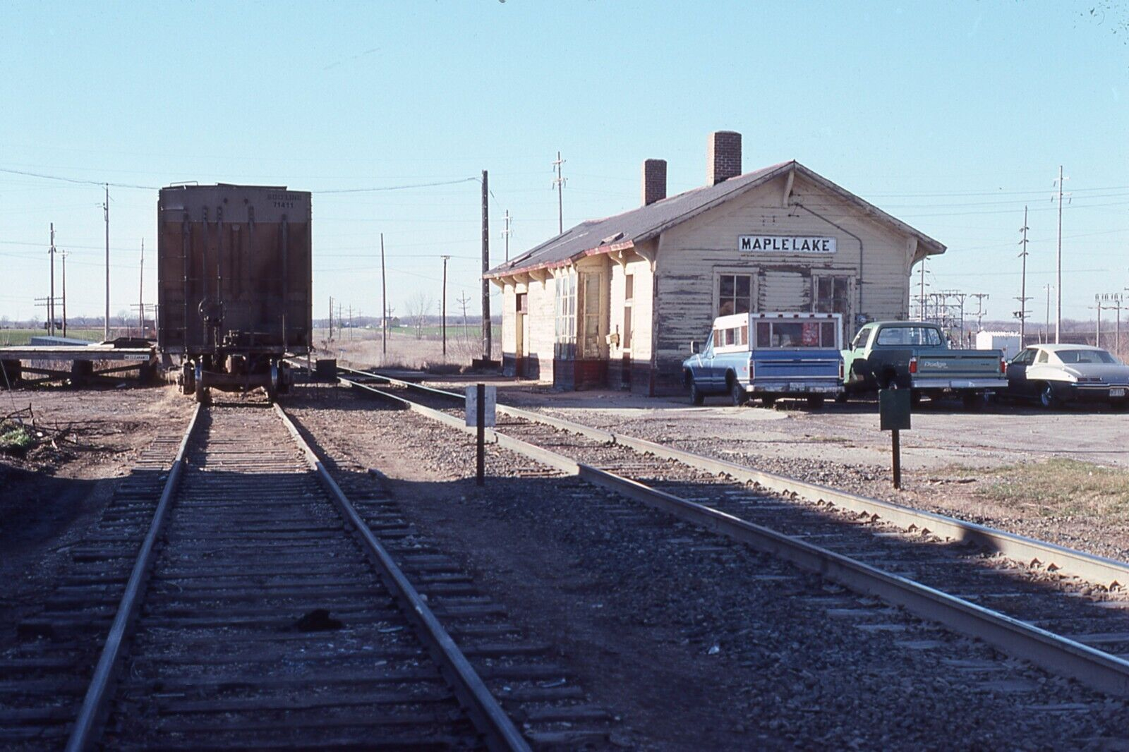
| Maple lake |
|
The depot was just west of Maple Avenue on the north side of the tracks. | ||||||
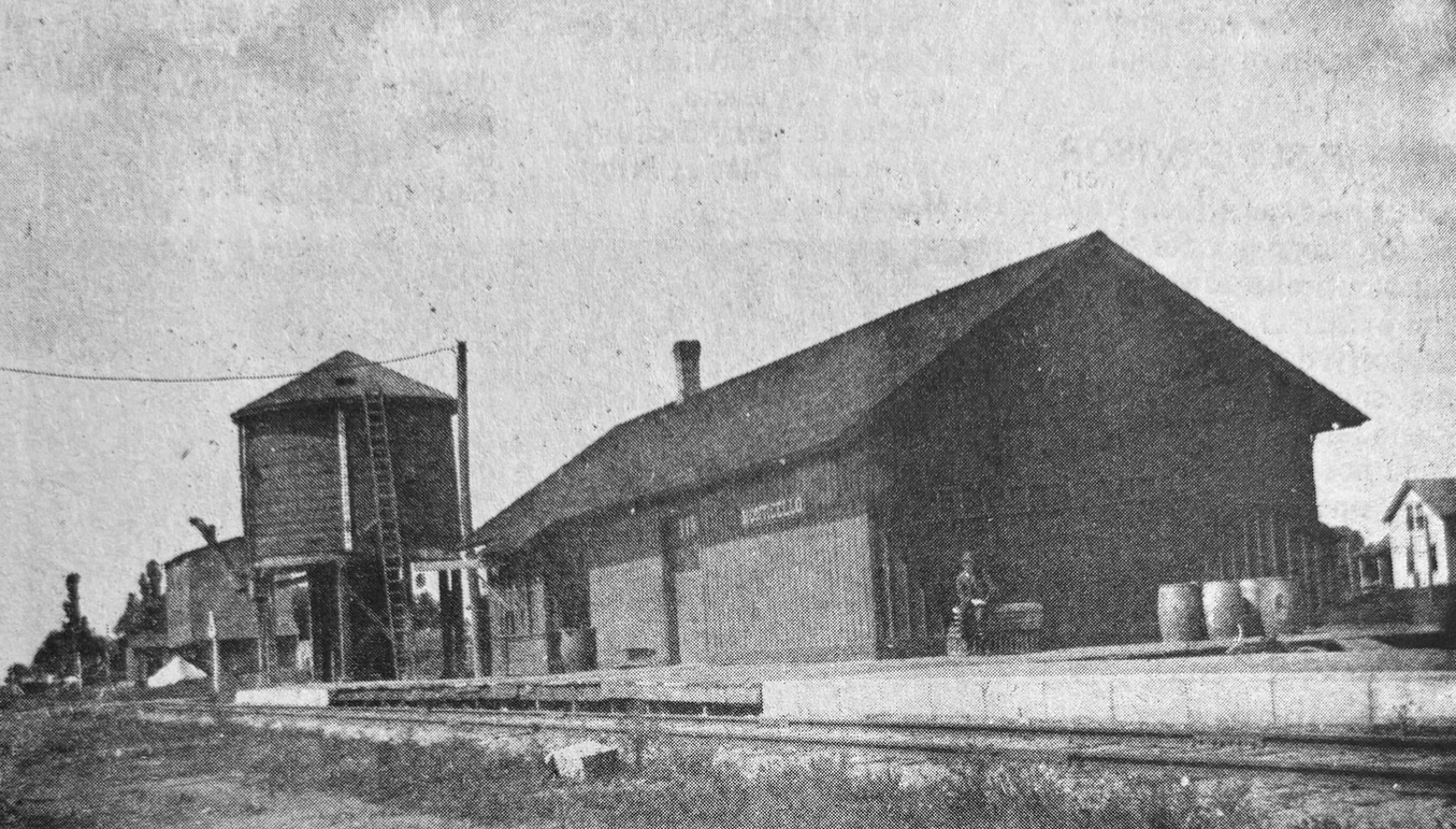
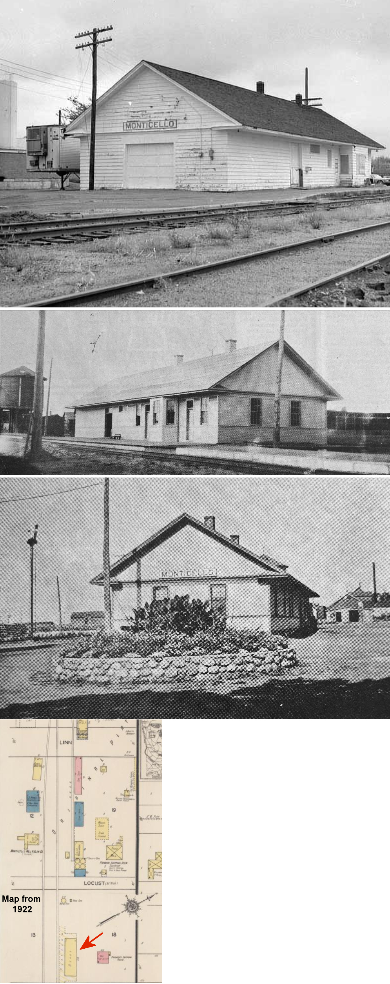
| Monticello |
|
The first station here was just NW of Walnut on the north side of the tracks at approximately GPS: 45.303572, -93.798728 (where a large factory sits today). This station burned down in 1909. | ||||||
| Monticello |
|
According to the 1915 GN Valuation Records, a new station was built here in 1909 (to replace the one that burned) that mesured 31'x97'. The new station was built at the same location as the original station. | ||||||
| Montrose |
|
According to the 1915 GN Valuation Records, a new station was built here in 1887 that mesured 20'x24'. It replaced an earlier station that burned down in May 1887 (New Ulm Review, 5-25-1887). | ||||||
| Rockford Station |
|
The first station here was a 1-story frame building erected in 1886. It was replaced by the second station here in 1909. That station only lasted two years, burning down in 1911. | ||||||
| Rockford Station |
|
This is the third station here. It was built in 1911 to replace the previous station that had burned. | ||||||
| Smith lake |
|
This station was at the south end of Ash Street on the north side of the tracks. This street, and most traces of the village, are now gone. According to the 1915 GN Valuation Records, the station mesured 20'x50'. The station was abandoned by the GN in January 1934. | ||||||
| South Haven |
|
This station was on the west side of Oak Avenue, on the north side of the tracks. The first M&P station here was built in 1886/7. That station burned down in 1906 and was replaced later that same year. The station closed in 1959 and was torn down in 1968. | ||||||
| Waverly |
|
The first station here burned down in 1893 (The Times-Enterprise, 4-25-1893). | ||||||
| Waverly |
|
The second station was at the southern end of 5th Street South (and Atlantic). It was built in 1893 and demolished by a derailed train in 1914 (Willmar Weekly Tribune, 1-14-1914). | ||||||
| Waverly |
|
The 3rd station was built in 1915 to replace the station above at the same location ( southern end of 5th Street South). It was moved to Waterfront Legion Park next to the baseball diamond, but was subsequently torn down around 2007 and a new building constructed in its place. The depot measured 24'x 84'. | ||||||
| 1898 WRIGHT COUNTY RAILROAD MAP | ||||||||
 |
||||||||
|
Notes About Existing Stations... Annandale (Soo) - This station's original location was on the north side of the tracks near the intersetcion of MN-55 and Harrison Street (GPS: 45.261384, -94.125216). An addition was made to the station in 1908. The depot closed in 1971 and in 1972 the depot was moved down Highway 55 to Pioneer Park. Clearwater (GN) - This is the second station in Clearwater. Not sure of its original location. Cokato (GN) - This station was moved from Cokato to Dassel in 1985. Passenger service ended in 1960 and the station closed in 1974. Its original location in Cokato was on the north side of 2nd Street between Jackson and Broadway Streets on the south side of the tracks at GPS: 45.077372, -94.191678. Montrose (GN) - This station has been moved about one block north its original location (which was on the west side of Buffalo Street). |
||||||||