 COUNTYCOUNTY
|
|
||||||||
| EXISTING STATIONS | ||||||||
|---|---|---|---|---|---|---|---|---|
| Station Name |
Original Railroad | Current Location |
Type | Date Built |
Current Use |
Track Status |
Building Material |
More Info |
| bixby |
 |
Austin Road at Village of Yesteryear at Steele County Fairgrounds (GPS: 44.068826, -93.218057) |
C | 1898 | Museum | None | Wood | |
| owatonna |
AND  |
State Avenue & Eisenhower Drive (GPS: 44.094063, -93.237736) |
C | 1887 | Business | None | Wood | |
| Owatonna |
AND |
20 Southridge Place (GPS: 44.093988, -93.208785) |
F | 1887 | Private | None | Wood | |
| owatonna |
 |
2300 Heritage Place NW (GPS: 44.130271, -93.249988) |
C | ???? | Church | None | Wood |
|
| STATIONS OF THE PAST | ||||||||
| Station Name |
Original Railroad |
Notes | ||||||
| Blooming Prairie |
|
The first station here burned down in 1892. While the new station was being built a small handcar house was used for the depot (Mower County Transcript, 8-31-1892). The original station was built without a bay window, but one was added in 1888. The station was on the west side of the tracks off US-218 near the intersection with 1st Street NE at GPS: 43.867715, -93.049393. Both the first and second stations here were in essentially the same location with the first station being a few more yards to the south. | ||||||
| Ellendale |
 |
This station was on the north side of 6th Street, on the west side of the tracks. | ||||||
| Havana |
|
This station was built in 1894. | ||||||
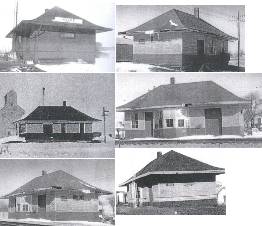
| Hope |
|
An old refrigerator car was used as the passenger station and an old boxcar was used as the freight station. They were placed there in 1906. The passenger station/refrigerator car burned down on February 16, 1911. The boxcar/freight station was then used for passengers until a new station could be built (The People's Press, 2-17-1911). | ||||||
| Hope |
|
After the station listed above burned down, the railroad built a new 20'x40' depot that opened in April 1911 (The People's Press, 4-21-1911). It was on the east side of the tracks at GPS: 43.961396, -93.277042. Passenger service ended in the late 1950s. | ||||||
| Lysne (Anderson) |
|
|||||||
| Medford |
|
This station was on the north side of 5th Avenue SE (formerly Oak Street), just east of Main. It was near where the old athletic fields were. There was also a freight hosue across the tracks. | ||||||
| Medford |
|
This station was on the east end of East Central Avenue, on the west side of the tracks. | ||||||
| Meriden |
|
This station was built in 1883. | ||||||
| Owatonna |
|
There was a freight station here built in 1867. It was on the west side of Elm Streeton the south side of the tracks near Front Street at GPS: 44.089891, -93.223803. | ||||||
| Owatonna |
|
The original freight station was on the east side of North Elm Street, just west of the Union Station. It was at GPS: 44.090613, -93.223340. It was enlarged sometime between 1894 and 1900. Sometime between 1900 and 1915 a new freight house was built on the west side of North Elm at GPS: 44.090917, -93.223935. At some point the Milwaukee Road abandoned the union station and moved passenger operations to the freight station. | ||||||
| Owatonna |
|
This station was near the intersection of Hillsdale and Riverside Streets at GPS: 44.086705, -93.231076. It was built in 1901 and torn down in 1985. The freight station was to the SE of the passenger station on the other side of the tracks at GPS: 44.086156, -93.230851. The freight station burned "beyond repair" in 1934 (The Austin Daily Herald, 5-11-1934). Not sure if a replacement was built after that. | ||||||
| Pratt |
|
|||||||
| Saco |
|
|||||||
| 1898 STEELE COUNTY RAILROAD MAP | ||||||||
 |
||||||||
|
Notes About Existing Stations... Bixby (CM&St.P) - This station was donated to the Steele County Historical Society by the railroad and moved to its current location in 1964. Owatonna (Union Station) - This station was originally on Front Street between Grove and Elm Streets at GPS: 44.089962, -93.222322. It was moved to its current location in 1977. Owatonna (Union Station) - This is the old baggage shed from the Union Station. It was located on the NW side of the station which was between the tracks and north of East Front Street at approximately GPS: 44.090087, -93.222674. It was moved to this private residence in 1992 after sitting vacant since the 1970s. In the photo of the building in its original location, you can see the grain elevator on Elm Street in the background. Owatonna (Replica) - This replica station was the former Heritage Halls Airplane Museum built by local businessman "Buzz" Kaplan. It is now the Christian Family Church and World Outreach Center.
|
||||||||