 COUNTYCOUNTY
|
|
||||||||
| EXISTING STATIONS | ||||||||
|---|---|---|---|---|---|---|---|---|
| Station Name |
Original Railroad | Current Location |
Type | Date Built |
Current Use |
Track Status |
Building Material |
More Info |
|
Claremont (Dodge Co.) |
 |
5841 Lonsdale Boulevard East (MN-19), Northfield (just west of St. Olaf College). (GPS: 44.455779, -93.191654) |
C | 1880 | Display | In Use | Wood |
|
|
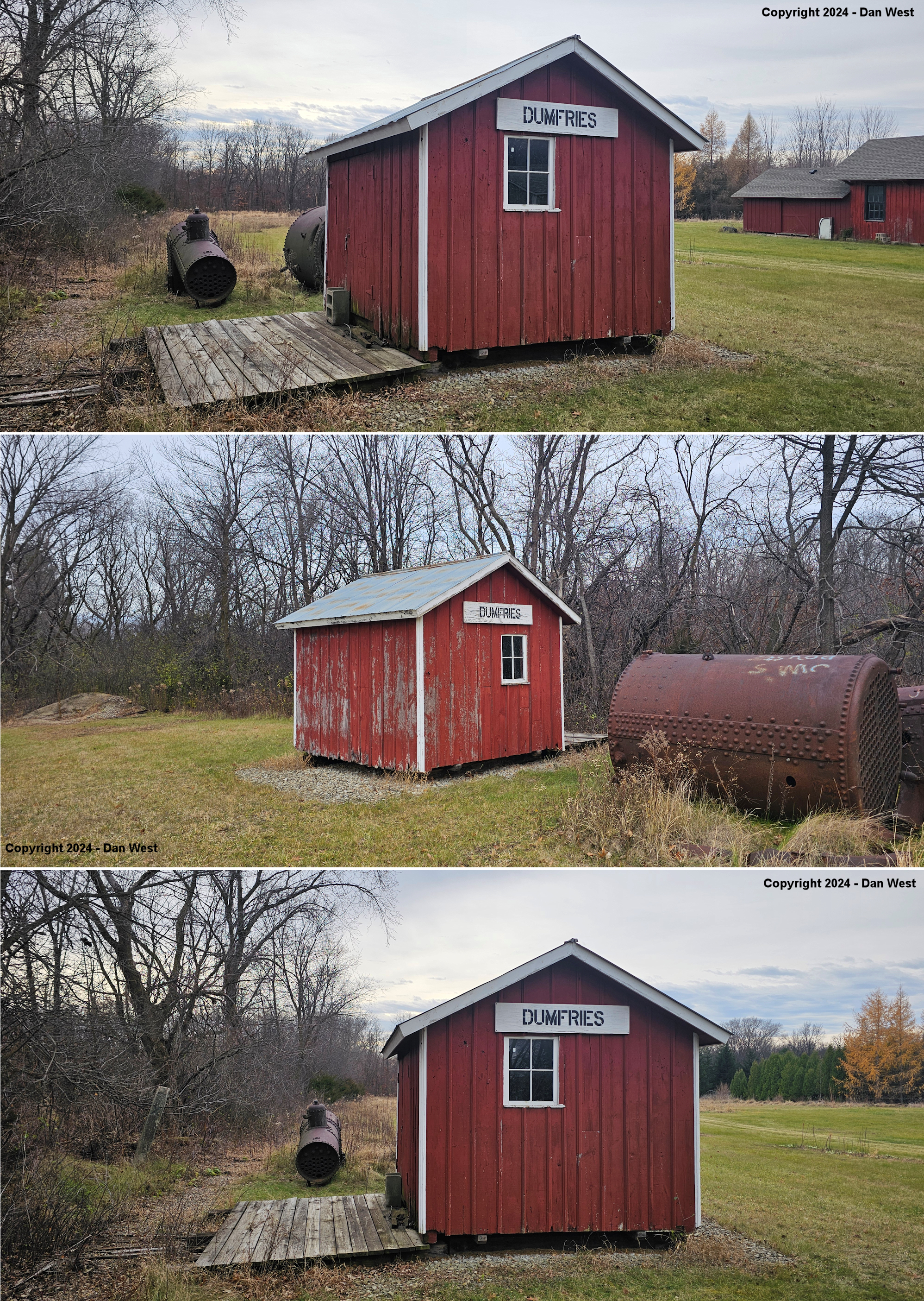
Dumfries (Wabasha Co.) |
 |
5841 Lonsdale Boulevard East (MN-19), Northfield (just west of St. Olaf College). (GPS: 44.455425, -93.191198) |
P | ???? | Display | In Use | Wood |
|
| faribault |
|
2nd Street NW and 9th Avenue NW (GPS: 44.292094,-93.282391) |
C | 1882 | Business | In Use | Brick | |
| faribault |
 |
3rd Street NE, just west of the river and to the east of MN-60. (GPS: 44.294236,-93.265429) |
C | 1902 | Business | In Use | Brick | |
| northfield |
AND |
Between 2nd Street West and 3rd Street West (GPS: 44.457709, -93.163487) |
C | 1889 | Railroad | In Use | Brick |
|
| webster |
|
Little Log House
Pioneer Village 220th Street, Hastings (Dakota Co.) (GPS: 44.630704, -92.837383) |
C | 1903 | Museum | None | Wood |
|
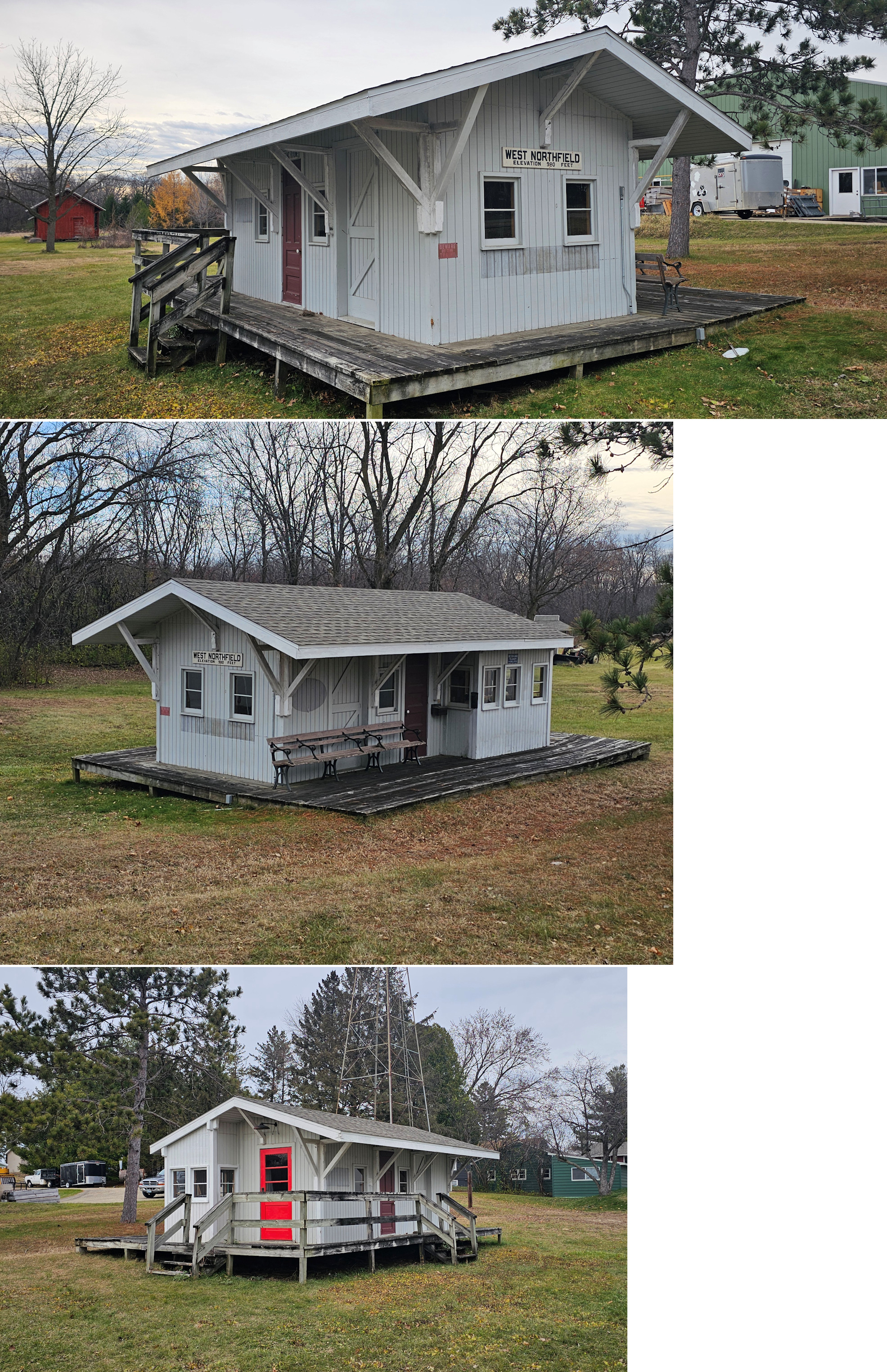
| West Northfield |
 |
5841 Lonsdale Boulevard East (MN-19), Northfield (just west of St. Olaf College). (GPS: 44.455936, -93.191577) |
C | ???? | ???? | None | Wood |
|
| STATIONS OF THE PAST | ||||||||
| Station Name |
Original Railroad |
Notes | ||||||
| Bridgewater |
 |
This station was between Dundas and Faribault. There may or may not have been a depot building here. It may have just been a flag stop with a station sign. | ||||||
| Cannon Lake |
|
Clarks Crossing was in the NW corner of Section 27 of Bridgewater Township. It was around GPS: 44.399172, -93.220940 where Faribault Boulevard crosses 130th Street. There was only a passenger waiting platform here. | ||||||
| Clarks Crossing |
|
There was only a passenger waiting platform here. | ||||||
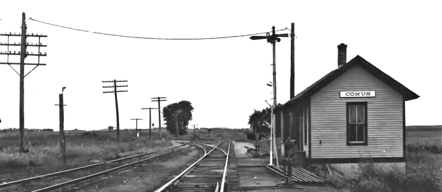
| Comus |
AND |
This station served both the Milwaukee Road and Rock Island. The Milwaukee served Comus from 1866 until 1985. The Rock Island joined the Milwaukee at Comus and from there north the Rock Island had trackage rights over the Milwaukee to Rosemount. | ||||||
| Dennsion |
|
|||||||
| Dundas |
AND  |
This station was on the NE corner of Railway and Hester Streets at approximately GPS: 44.431195, -93.206040. It was built in 1882 and closed in 1954. The CGW had previously tried to close the station in 1924, but a court ruling kept it open with the MN&S footing part of the expenses (The Austin Daily Herald, 6-11-1924). | ||||||
| Dundas |
AND |
This depot was on the south side of West Street. | ||||||
| Epsom |
|
Built in 1903. | ||||||
| Erin |
|
This station was between Dundas and Comus. Although the Rock Island had trackage rights here, this was a Milwaukee Road-only stop. | ||||||
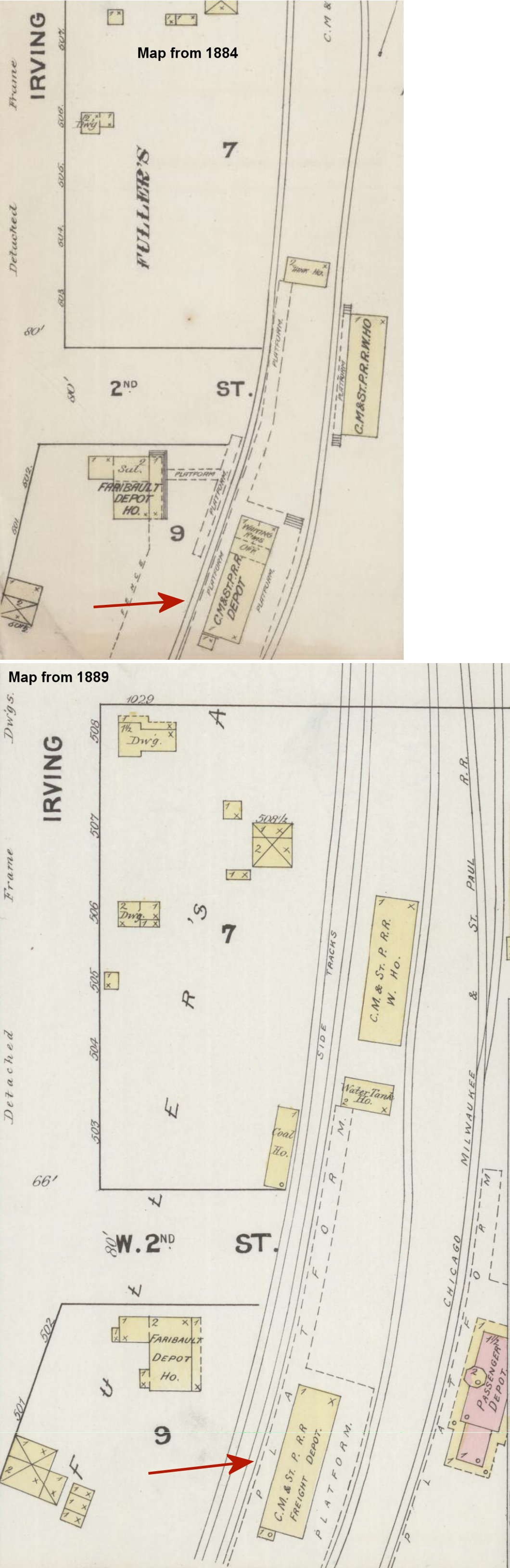
| Faribault |
|
The original wooden passenger station was on the south side of 2nd Street NW on the west side of the tracks on a siding at GPS: 44.292038, -93.282958. This station was likely built by the Minnesota Central Railway in the mid-1860s There was also a freight warehouse across the tracks. The nearby Faribault Depot Hotel also had a walkway and platform along the tracks (see maps). When the brick station was built sometime between 1884-1889 (see Sanborn maps), the old combination station then served as the freight station. According to the Rice County Journal, 8-31-1882, however, the new brick station was just getting underway that year. Given that there was a lag between when the maps were plotted and published, that is a likely date. | ||||||
| Faribault |
|
Sometime between 1909-1914 the freight station (original passenger station) was moved or a new one was built on the north side of 2nd Street at GPS: 44.292641, -93.281728. | ||||||
| Faribault |
|
The first station was on 12th Street NW between 3rd and 4th Avenues NW in the vicinity of GPS: 44.303544, -93.273829. The station was torn down when the new station was built on the downtown spur in 1900. This old station is partially shown on the Sanborn map from 1899 with the note, "Railroad depot to be removed to Willow Street near business part of town." | ||||||
| Faribault |
|
This was the second generation station. It was built in 1900 on the new CGW "downtown spur" and demolished in 1978. It was on the NE corner 1st Street NE and 1st Avenue NE (formerly North Willow) at GPS: 44.291541, -93.266476. | ||||||
| Faribault |
|
The freight station was on the south side of 1st Street NE at GPS: 44.291268, -93.266345. It was also built in 1900. | ||||||
| Faribault |
|
The freight station was on the south side of 3rd Street NE at GPS: 44.293178, -93.265538. | ||||||
| Hildebrand |
|
|||||||
| Kasper Siding |
|
This station was southeast of Faribault on the east side of Section 16 in Walcott Township. | ||||||
| Lake City |
|
There is no station shown here on the 1902 map, however there may have been one previously. | ||||||
| Lonsdale |
|
This station was on Railway Street at 2nd Avenue NW at GPS: 44.481108, -93.430358. There is a modern building (built in 1985) at that site now. According to the book "Then & Now: A History of Rice County, Faribault, and Communities" (1976), the Lonsdale station was moved to the "Prior Lake Mall." If the station was moved to the Priordale Mall when it was built in the 1970s, the depot likely no longer exists as the mall has undergone a couple significant remodelings since then and a name change (now known as South Lake Village). | ||||||
| Morristown |
|
This station was on the west side of 4th Street, on the south side of the tracks. The first station here was built in 1882 with a subsequent station built in 1905. That second-generation station was closed in 1962 and sold to an R.R. Kirchner for $25. | ||||||
| Nerstrand |
|
This station was on the south side of Main Street. The first station here was built in 1885 (not sure if that is the one pictured). | ||||||
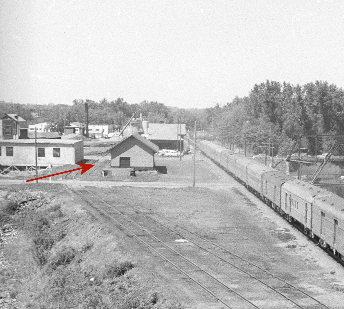
| Northfield |
|
This brick station was on the north side of 3rd Street NW at GPS: 44.457501, -93.163728. It was built in 1903 (The Saint Paul Globe, 10-27-1903). The CGW freight station was just to the north and can be seen in the photo. This freight station may have been built as the M&St.L passenger station when it owned the line and was the passenger station for the CGW before the brick station was built. | ||||||
| Northfield |
|
Built in 1910. | ||||||
| Northfield |
|
The first station here was built in 1865. It was little more than a 16x16 shack. It was moved in 1870. | ||||||
| Northfield |
|
Built in 1868 by the Minnesota Central RR, this station was just south of 3rd Street West. It either was destroyed by fire in 1888 or became part of the existing freight depot. | ||||||
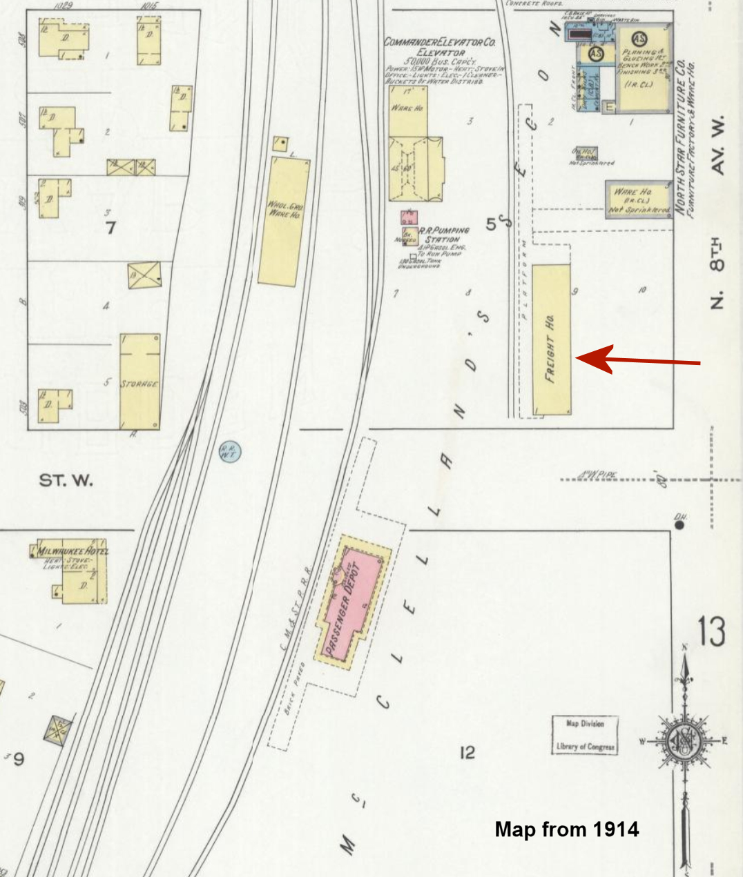
| Northfield |
AND |
This freight station was on the north side of 3rd Street West, just west of MN-19/MN-3 at GPS: 44.457709, -93.163487. This building is shown as the freight station on 1902 maps. It also served the CRI&P and there is an outline of a CRI&P sign that can be seen in the photos. | ||||||
| Ruskin |
|
Built in 1903. | ||||||
| Sheffield Mill |
|
This station was between Faribault and Cannon Lake. There was no depot structure here, only a waiting platform. | ||||||
| Walcott |
|
This station was south of Faribault in the SW corner of Section 18 in Walcott Township. | ||||||
| Warsaw |
|
The station was east of Main Street down in the area near Falcon Way. In the old days this was the extreme SE corner of town. In later years at least, there was a boxcar body used as a station. That boxcar depot was retired in 1956. | ||||||
| 1898 RICE COUNTY RAILROAD MAP | ||||||||
 |
||||||||
|
Notes About Existing Stations... Claremont (C&NW) - This station was moved to its current location from Claremont in Dodge County. It was part of a private display owned by Jim Machacek that featured a 2' gauge railroad called the Northfield & Cannon Valley (which operated from the 1960s through 2007; Jim passed away in 2012). The railroad has been removed as of 2024, but the stations remain on the property. The station's original location in Claremont was on the west side of Elm Street on the south side of the tracks. Dumfries (CMSt.P&P) - This station has a (non-authentic) sign indicating "Dumfries," but is it the actual station that was at Dumfries (Wabasha County)? Need some confirmation of that. It was part of a private display owned by Jim Machacek that featured a 2' gauge railroad called the Northfield & Cannon Valley (which operated from the 1960s through 2007; Jim passed away in 2012). The railroad has been removed as of 2024, but the stations remain on the property. Northfield (CM&St.P - Passenger) - The station's original location was on the south side of 3rd Street West, just west of MN-19/MN-3 at GPS: 44.456858, -93.164245. The station was moved north to its current location in January 2016. It now sites approximately where the CGW passenger station was. Webster (CMStP&P) - This station was moved from its original location to Little Oscar's Cafe on US 52 in Hampton where it was for a number of years. The former owner of the cafe, Oscar Palrud, was well-known railroad buff from Faribault who traveled all over the world via rail. Around 2008-09 it was moved to Little Log House Pioneer Village in Dakota County. West Northfield (Unknown) - Does anyone know the origin/railroad of this station? Is it a replica, or an authentic station? |
||||||||