 COUNTYCOUNTY
|
|
|||||||||
| EXISTING STATIONS | |||||||||
|---|---|---|---|---|---|---|---|---|---|
| Station Name |
Original Railroad | Current Location |
Type | Date Built |
Current Use |
Track Status |
Building Material |
More Info |
|
| Blue Earth |
 |
NW Corner of West 1st Street and Childs Street (GPS: 43.644979,-94.111939) |
C | 1880 | Storage | In Use | Wood |
|
|
| huntley |
 |
110 West Maine Street in Amboy (Blue Earth Co.) (GPS: 43.888226, -94.158826) |
C | 1879 | Business | None | Wood |
|
|
| walters |
 |
3/4 mile south of CR-31/CR-30 | C | ???? | Garage | None | Wood |
|
|
| wells |
|
100 1st Avenue NW at 1st Street NW. (GPS: 43.746099,-93.726801) |
C | 1903 | Civic | In Use | Brick | ||
| STATIONS OF THE PAST | |||||||||
| Station Name |
Original Railroad |
Notes | |||||||
| Blue Earth |
AND  |
This station was built in 1899. It was on the north side of 6th Street at GPS: 43.638901, -94.094610. When it was built the original depot (still standing on the NW side of town) was moved north a half block to serve as the freight station. This 1899 station was torn down in December, 1967 and the RR moved passenger operations to a trailer. | |||||||
| Blue Earth |
|
Before the "union" station listed above was built, the C&NW had its own station, but it was closed in 1902 (The Wells Forum, 5-6-1902). It's not clear where it was located as old Sanborn maps do not cover most of the C&NW route through town. | |||||||
| Bricelyn |
|
The original C&NW station burned down in April 1916 due to a lightning strike. | |||||||
| Bricelyn |
|
This replacement station for the one listed above was built later in 1916. In 1917 the freight end caught fire, but the building was preserved. | |||||||
| Bricelyn |
|
This station was built in 1900 according to The Rock Island Digest vol 14 (1997) "BCR&N Classic Two Story Buildings." The BCR&N merged with the Rock Island in 1903. Any station built before the merger would have been of BCR&N provenance, so this is likely most or all stations on the Rock Island in Minnesota. | |||||||
| Delavan |
|
After serving as a depot, the station was moved to the east side of town and used for storage. It was torn down around 2000 for lack of maintenance. | |||||||
| Easton |
|
||||||||
| Elmore |
|
Built in 1902, this was the second station here. It was on the north side of Willis Street on the east side of the tracks at GPS: 43.504886, -94.089291. The previous station, which was smaller, was at the same location. | |||||||
| Frost |
|
According to the book Minnesota Place Names: a Geographical Encyclopedia by Warren Upham - "Frost a city in Rome Township was named for Charles S. Frost, an architecto of Chicago." Charles Sumner Frost and his partner, his brother-in-law Alfred Hoyt Granger, married daughters of C&NW president Marvin Hughitt. Frost with and without Granger designed 127 buildings for the C&NW. | |||||||
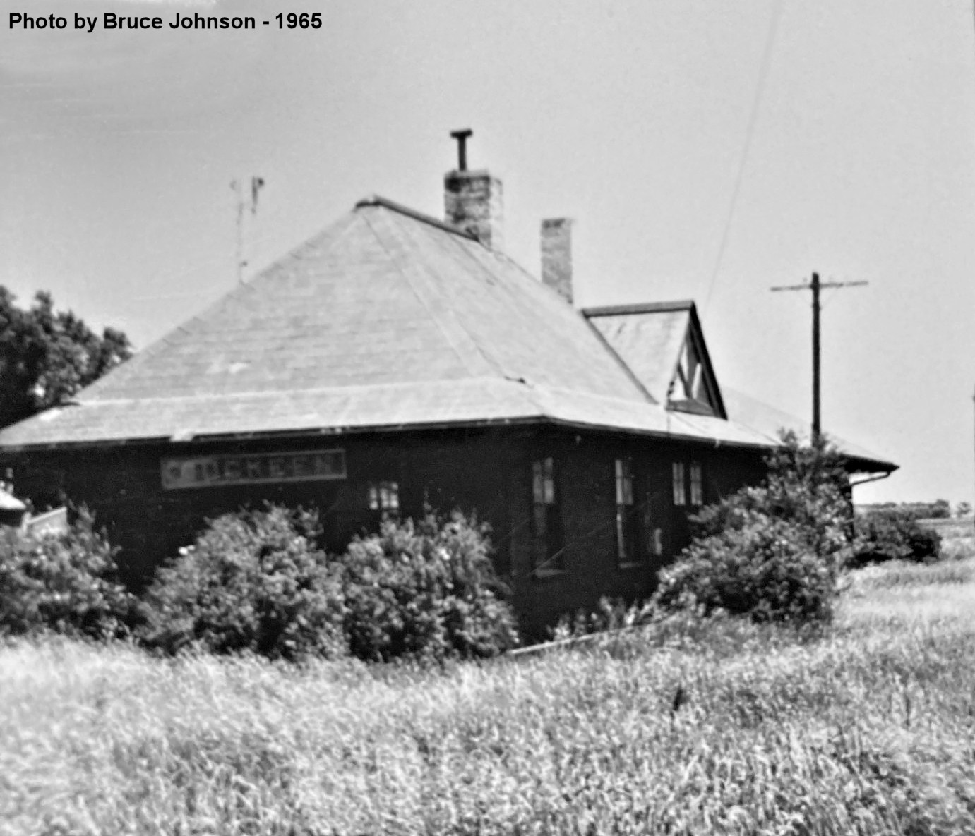
| Guckeen (Derby) |
|
Built in 1899. | |||||||
| Kiester |
|
Built in 1900. | |||||||
| Minnesota Lake (Minnesota) |
|
This station was north of 4th Avenue on the west side of the tracks at GPS: 43.843892, -93.831431. It appears from Sanborn maps that a new, larger, depot was built between 1910-1927. The old and new depots were at approximately the same location with the new station being just a few feet north of the old one. | |||||||
| wells |
 |
This was the original station before the newer brick CM&St.P station was constructed. It was on the west side of North Broadway Street (formerly C Street) at GPS: 43.745796, -93.725830. Some news articles (The Forum-Advocate, 6-27-1901) claimed that the old passenger station was planned to be converted into the freight station (listed below). It's not clear whether that happened or if a new freight station was constructed along with the new passenger station. | |||||||
| Wells |
|
According to The Albert Lea Tribune (12-20-1938), the freight station was sold in 1938 to B.W. Musser who planned to move it to his property to use as a hatchery building. Does anyone know the eventual fate of the building? | |||||||
| Winnebago |
|
This station was built in 1908 after the previous station burned down due to a lightning strike (The Bricelyn Sentinel, 7-24-1908). Both the old and new stations were on the north side of Cleveland Avenue at GPS: 43.768397, -94.158173. | |||||||
| Winnebago |
|
In 1899 this station was on the east side of 8th Street (now 3rd Street SE) at GPS: 43.764337, -94.161319. | |||||||
| 1898 FARIBAULT COUNTY RAILROAD MAP | |||||||||
 |
|||||||||
|
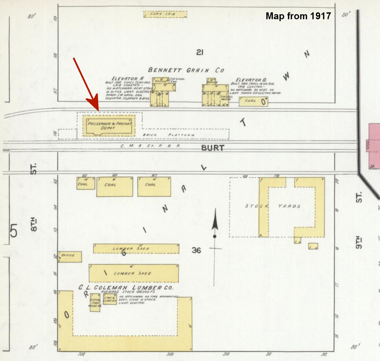
Notes About Existing Stations... Blue Earth (Omaha) - This was the original freight/passenger station from 1880. Later, after the newer, larger station was built, it served as a freight station. It was moved from its second location on the south side of East 5th Street on the west side of the tracks (GPS: 43.639469, -94.094565) on by contractor Norbert Mensin. Its original location was just to the south on the north side of 6th Street. It was moved north a bit when the new station was built in 1899. Huntley (CM&St.P) - Moved from original location to 31710 170th Street, then to Amboy, MN. The depot was given to the Amboy Area Community Club free of charge with the condition that it be restored. The project was started in 2011 and the station was restored by 2013. Walters (Rock Island) - First story and freight section removed. Second story remodeled and used as a garage. I attempted to locate this station in 2024, but could not find it. Does anyone know of its disposition or exact location? |
|||||||||