|
|
||||||||
| EXISTING STATIONS | ||||||||
|---|---|---|---|---|---|---|---|---|
| Station Name |
Original Railroad |
Current Location |
Type | Current Use |
Date Built |
Track Status |
Building Material |
More Info |
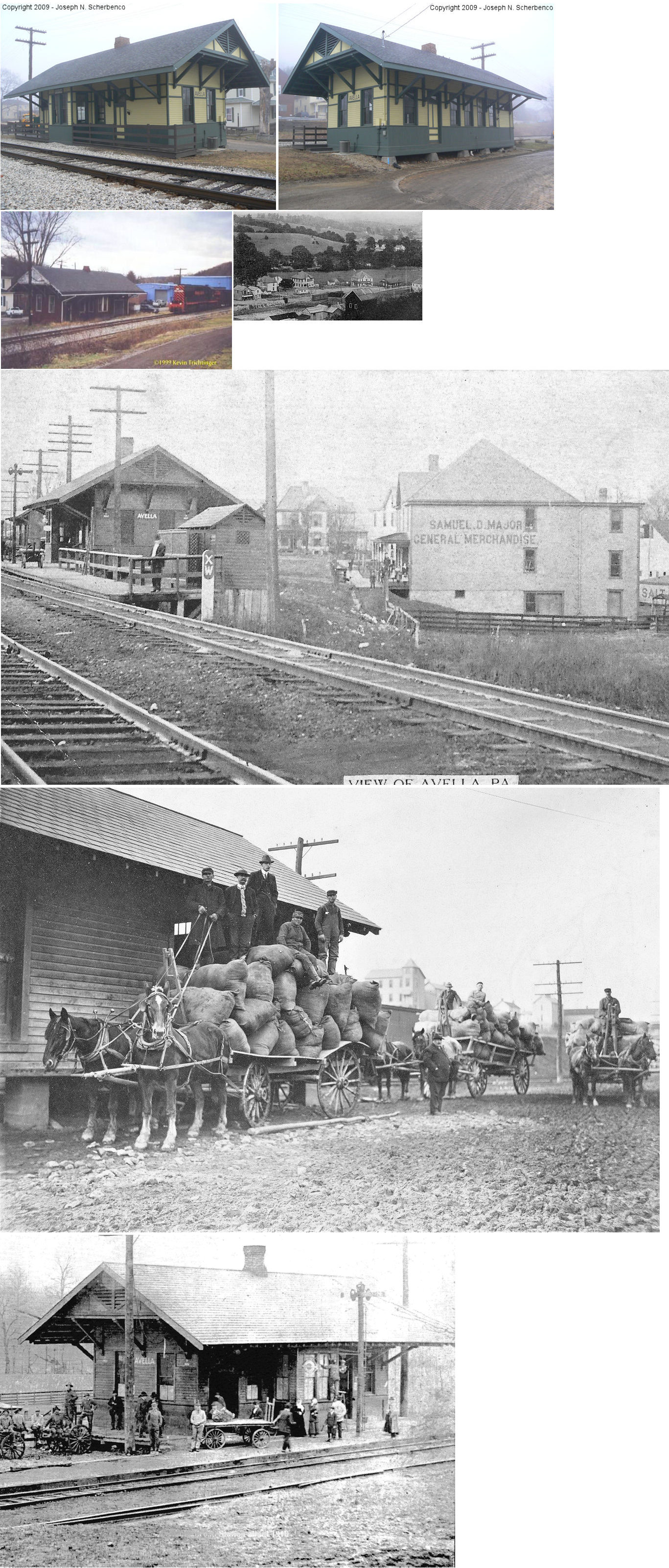
| Avella (Prior) |
 |
Seneca place off PA50 (Avella Road) (GPS: 40.273650, -80.459956) |
C | Society | 1904 | In Use | Wood |
|
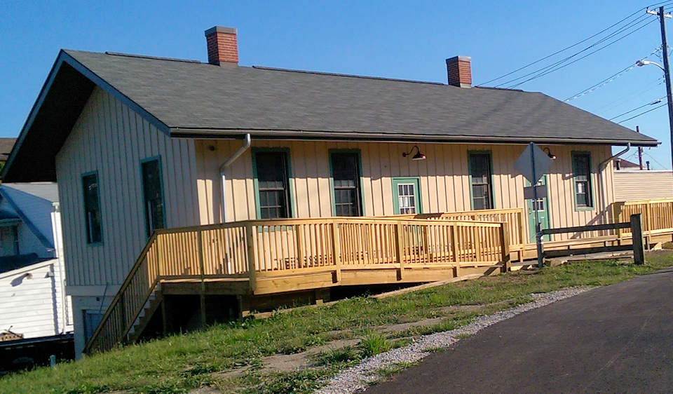
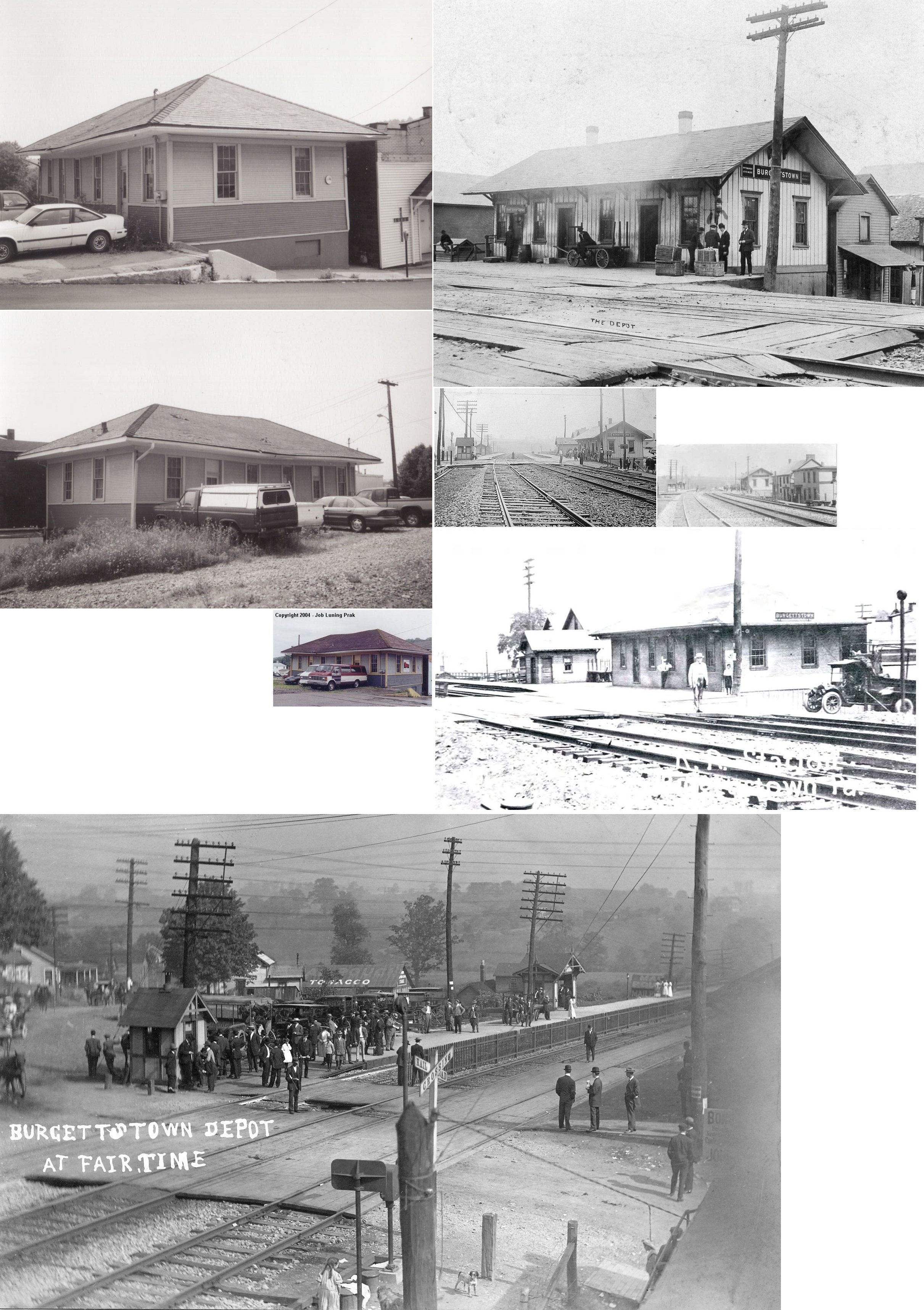
| Burgettstown |
 |
PA18 northeast of Bridge Street (GPS: 40.387676, -80.387993) |
F | Business | ???? | Gone | Wood | |
| Burgettstown |
 |
NE side of North Main Street SE of Whataker Street (GPS: 40.386702, -80.390575) |
R | Business | 2010 | Gone | Wood |
|
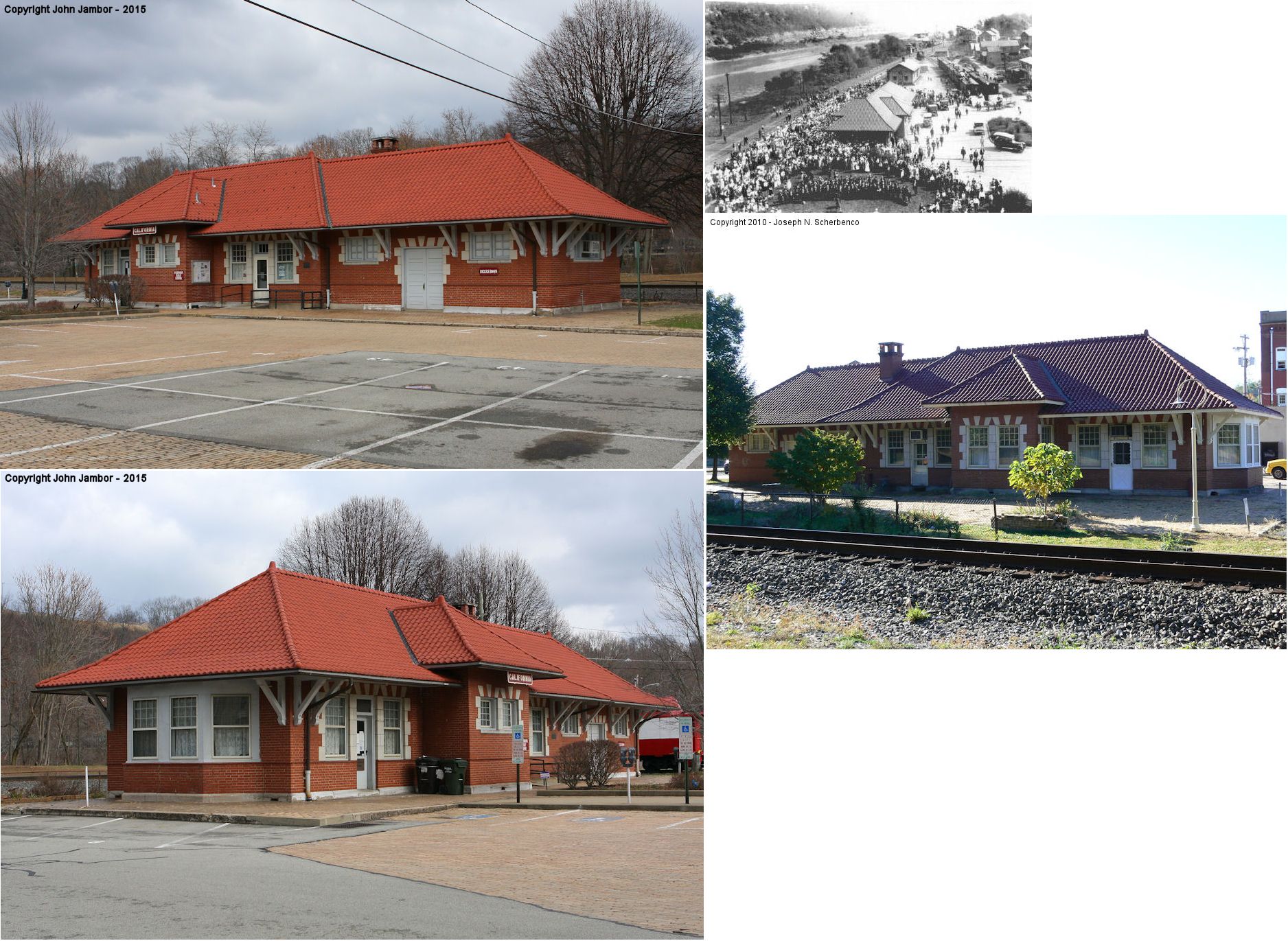
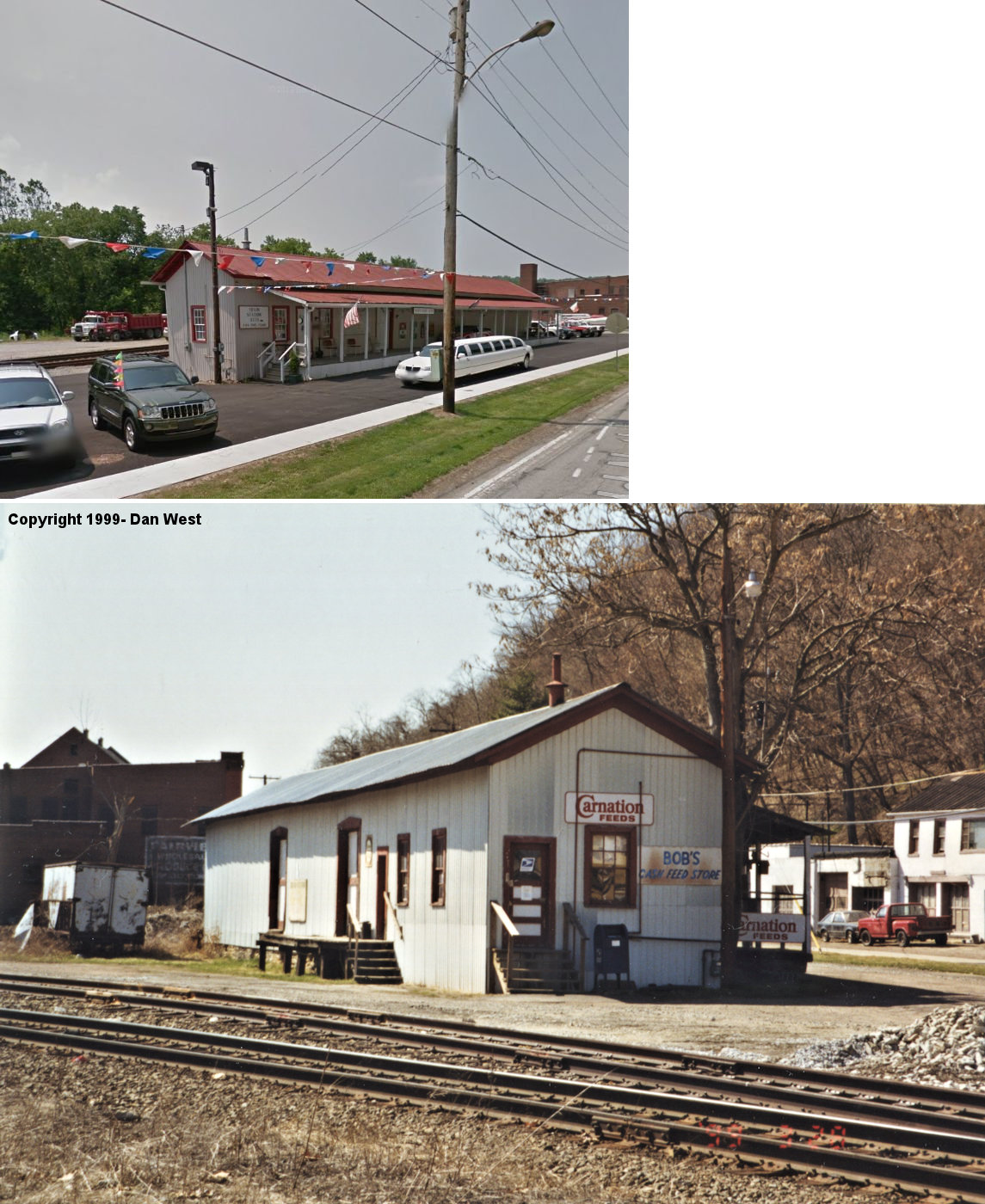
| California |  |
Temperance Way & Wood Street (GPS: 40.068273, -79.889072) |
P | Library | 1910 | In Use | Brick |
|
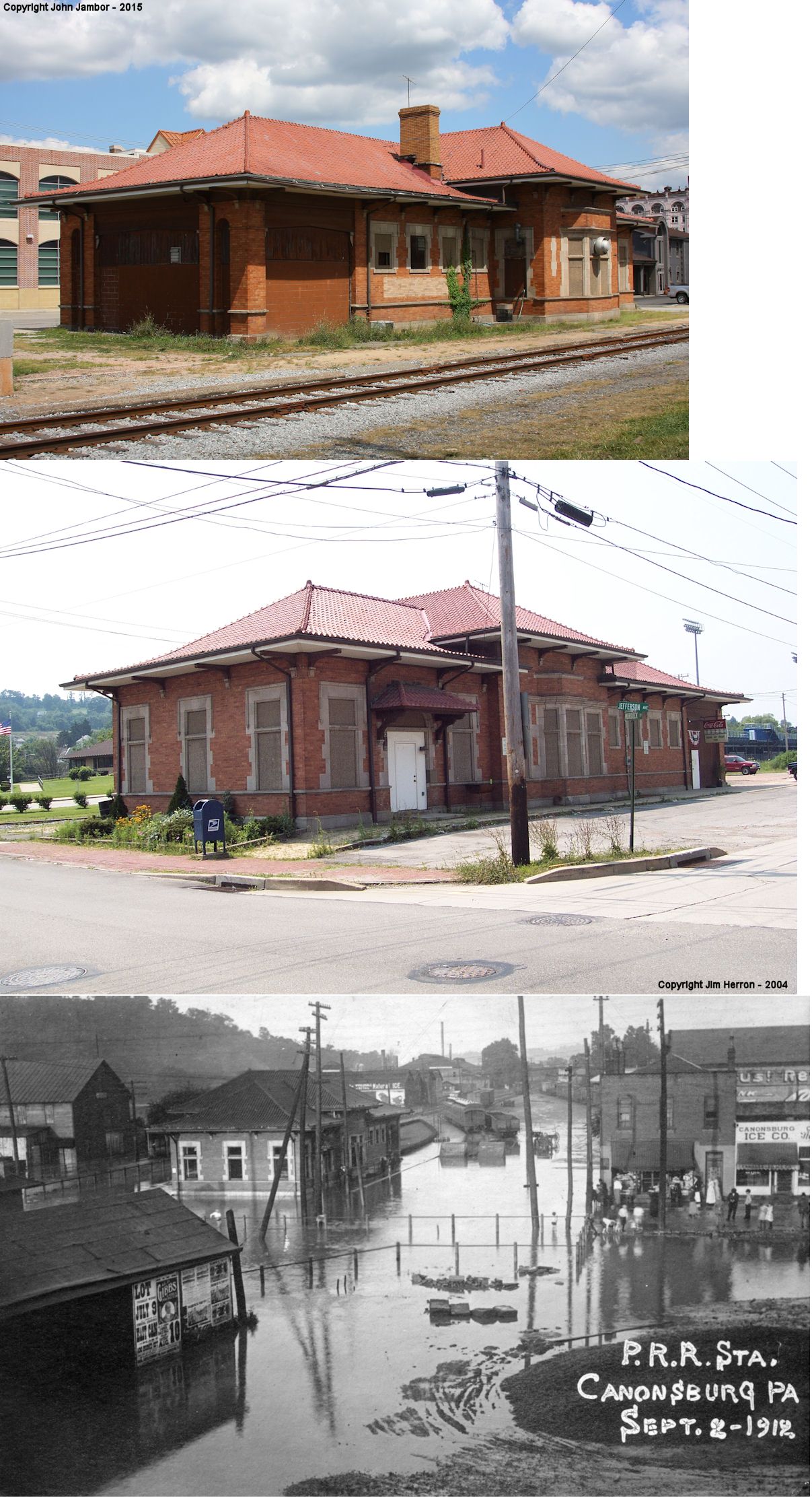
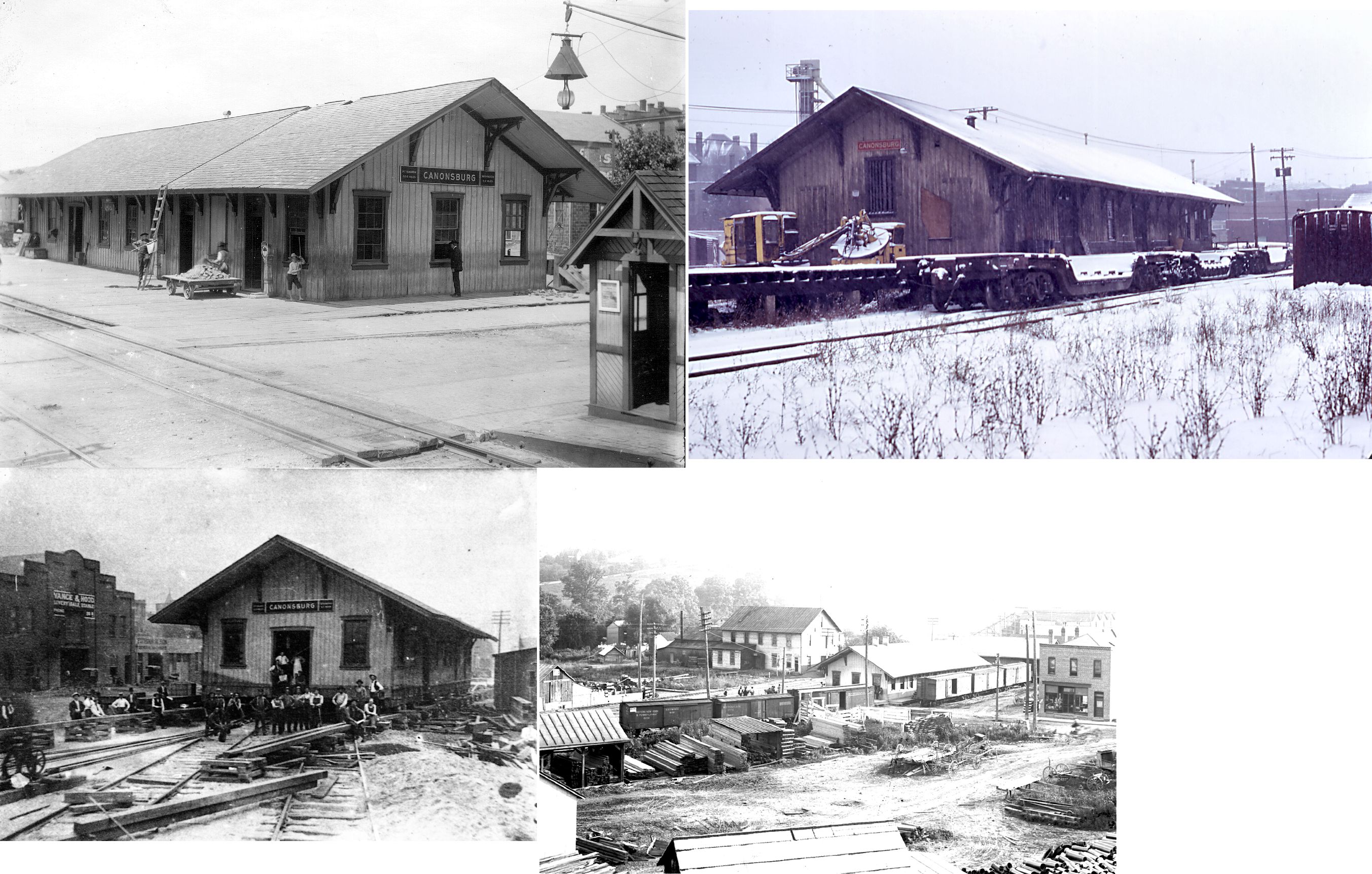
| Canonsburg | |
Murdoch Street & Jefferson Avenue (GPS: 40.257489, -80.188225) |
P | Civic | 1909 | In Use | Brick | |
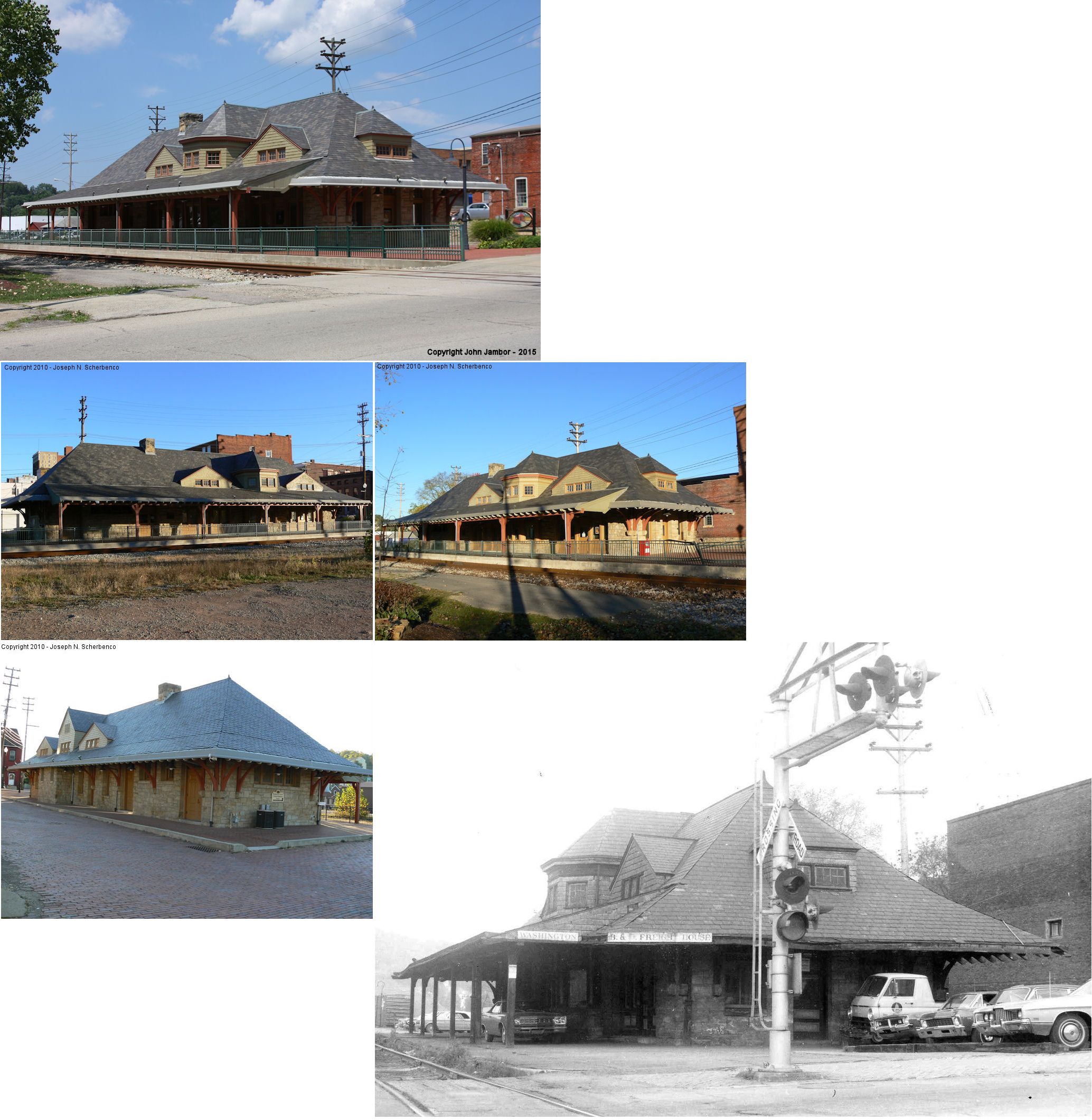
| Washington |  |
273 South Main Street (GPS: 40.166898, -80.244798) |
C | Railroad | 1888 | In Use | Stone/ Wood |
|
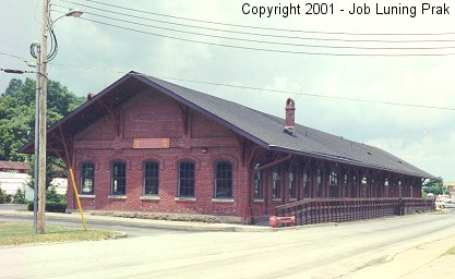
| Washington | |
123 Washington Street (GPS: 40.172217, -80.254136) |
F | Businesses | 1884 | In Use | Brick | |
| Washington |
|
South Main Street & Park Avenue (GPS: 40.165243, -80.243660) |
P | Storage | 1906 | Gone | Brick |
|
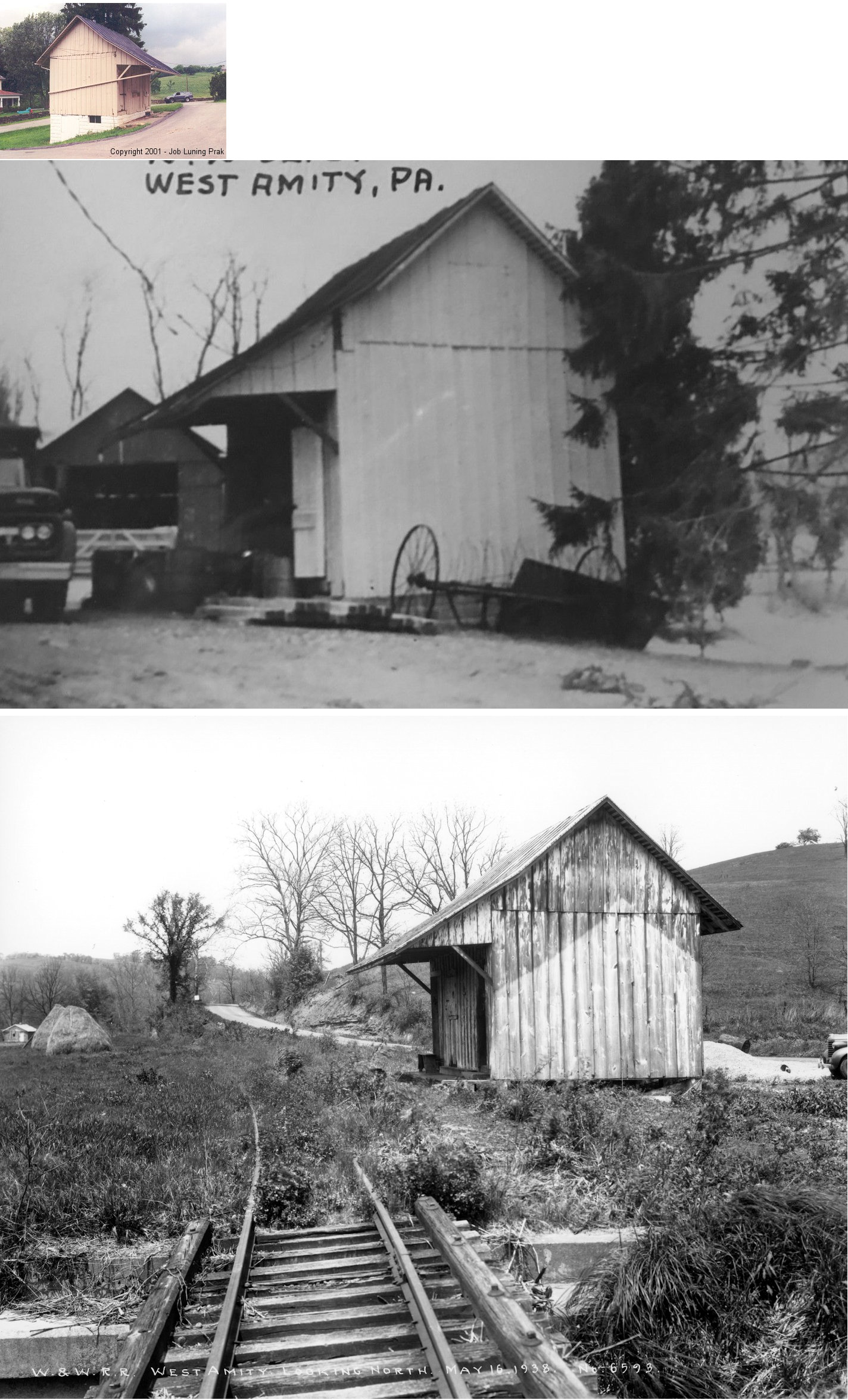
| West Amity |  |
51 West Hillsboro Road (GPS: 40.039795, -80.217699) |
P | ???? | ???? | Gone | Wood | |
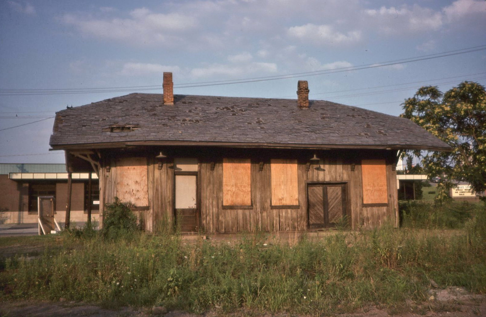
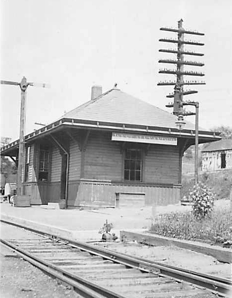
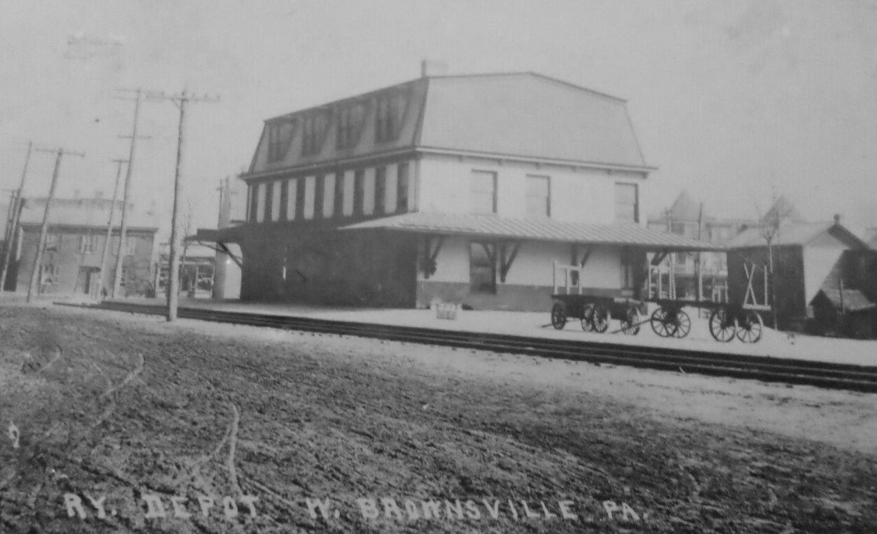
| West Brownsville | |
South side of Main Street just west of Blaine Avenue. (GPS: 40.023787, -79.892004) |
F | Business | ???? | Gone | Wood |
|
| STATIONS OF THE PAST | ||||||||
| Station Name |
Original Railroad |
Notes | ||||||
| Acheson |
|
This station was between George and McCoy. | ||||||
| Allenport |
|
This station is listed on the 1923 PRR List of Stations & Sidings. | ||||||
| Amwell |
|
This station was near the intersection of Hinerman and Banetown Roads at approximately GPS: 40.105505, -80.243200. This was a flag stop station with a simple shelter. It appears on 1895 maps of Washington and Waynesburg Railroad stations. | ||||||
| Arden (Cooks) |
|
|||||||
| Atlasburg |
|
This station was at the southern end of the Burgetts Branch. | ||||||
| Avella |
|
There was a small freight station just to the NW of the passenger station closer to Wilson Avenue at GPS: 40.274003, -80.460196. | ||||||
| Bairds Station |
|
This station is shown on the 1884 map of the Monongahela River between Black Diamond Station and Webster Station. | ||||||
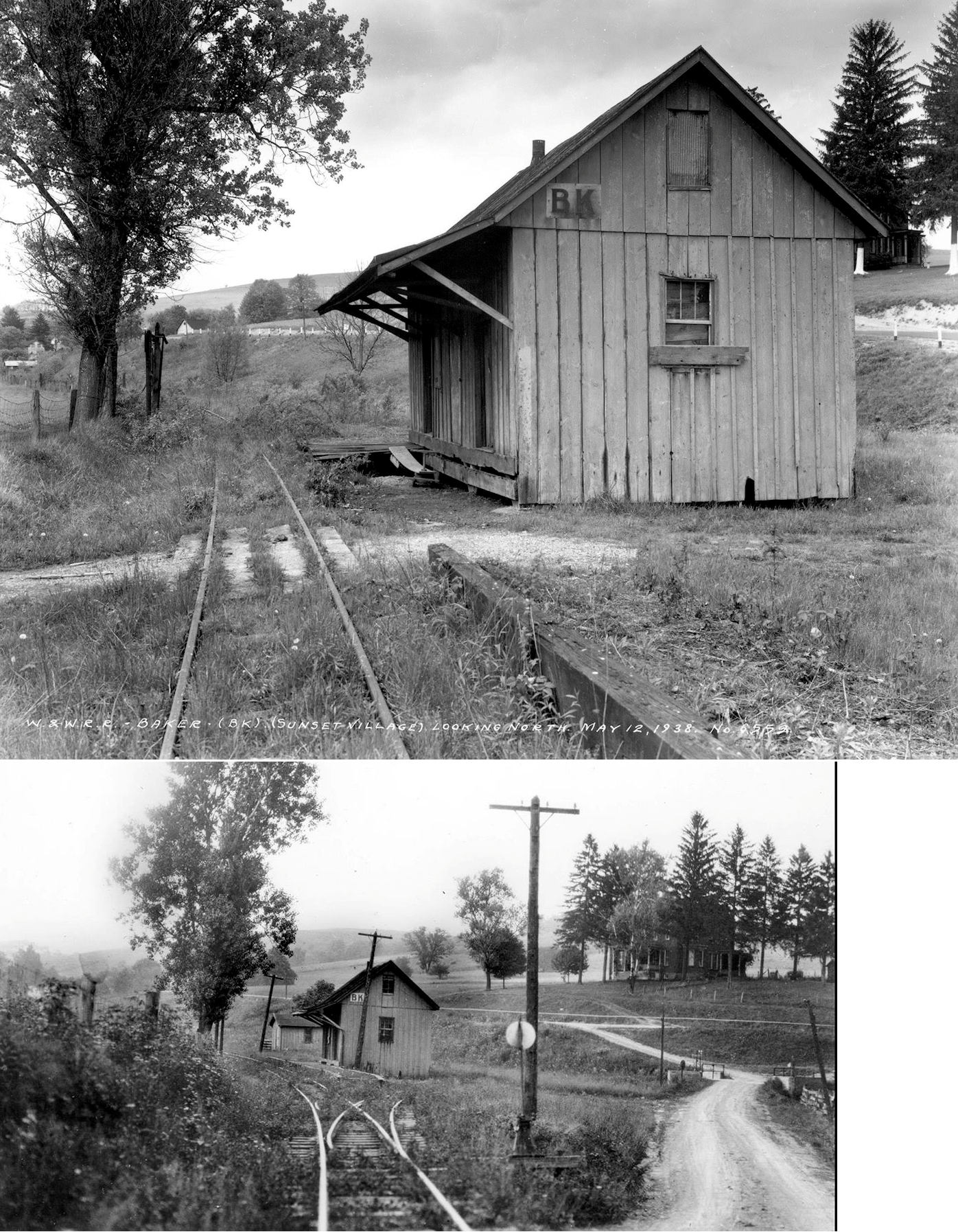
| Baker |
|
|||||||
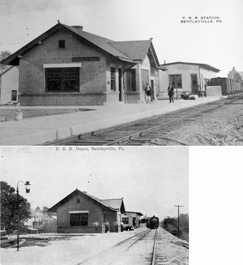
| Bentleyville | |
The passenger and freight stations were on the west side of the tracks north of Washington Street at GPS: 40.118684, -80.006505. The passenger station was closer to Washington Street with the freight station a bit to the north. | ||||||
| Bertha (Dinsmore) |
|
|||||||
| Besco |
|
This station is listed on the 1923 PRR List of Stations & Sidings on the Ten Mile Run Branch. | ||||||
| Bishop |
|
This station is listed on the 1923 PRR List of Stations & Sidings on the Bridgeville & McDonald Branch at the end of the one-mile Miller's Run Extension. | ||||||
| Bishop |
|
This station was one mile from the Cecil station. | ||||||
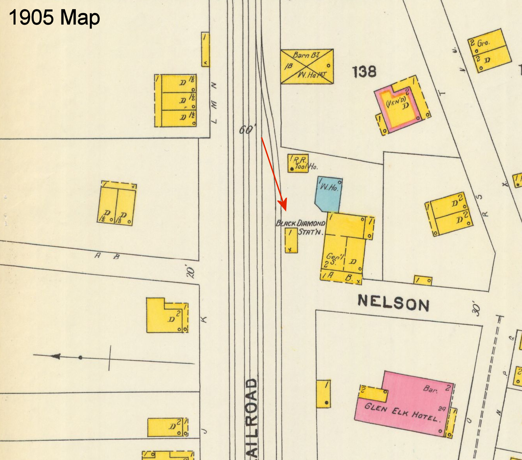
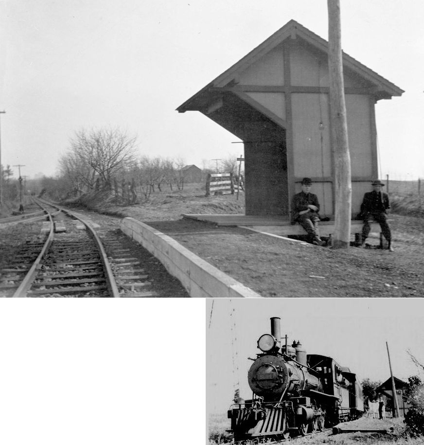
| Black Diamond Station |
|
This station was along PA837 near Black Diamond Hollow Road at approximately GPS: 40.193047, -79.897499. It is shown there on the 1884 map of the Monongahela River. On the 1905 Sanborn map of Monongahela, the station is show on the west side of Nelson Street on the north side of the tracks at GPS: 40.193445, -79.902228. On that map it appears to be little more than a passenger waiting shed. | ||||||
| Blainesburg |
|
The station was near the north end of Main Street (formerly Railroad Street) at approximately GPS: 40.035677, -79.881701. This station is shown on the 1921 Sanborn map of Brownsville. | ||||||
| Bonnymeade |
|
This station is listed on the 1923 PRR List of Stations & Sidings on the Hickory Branch. | ||||||
| Braddock | |
The station was at the intersection of Braddock Road and Sanitarium Road. | ||||||
| Brevard |
|
This station is listed on the 1923 PRR List of Stations & Sidings on the Westland Branch. | ||||||
| Broxton |
|
This station is listed on the 1923 PRR List of Stations & Sidings on the Westland Branch. | ||||||
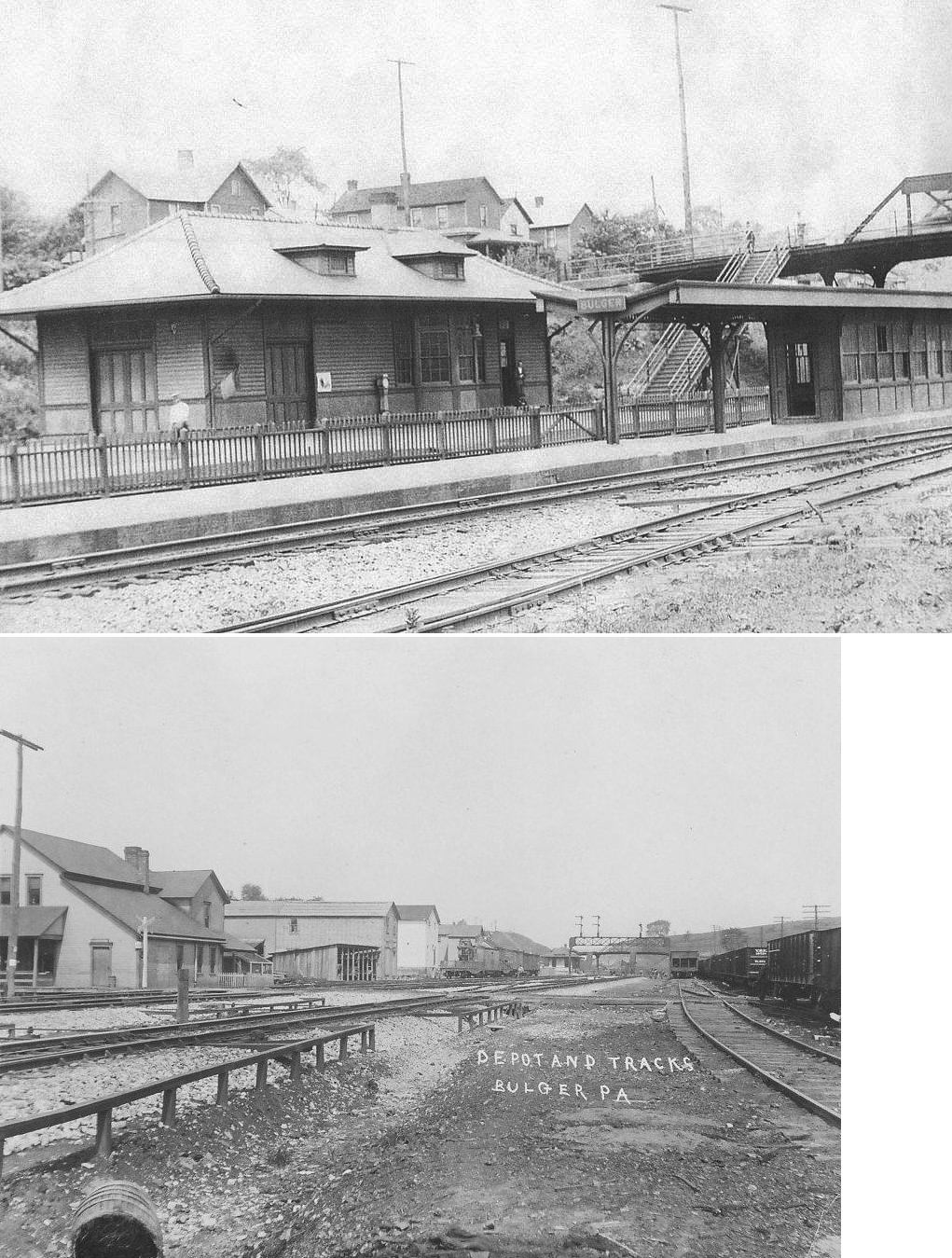
| Bulger |
|
This station was on Lincoln Street just SE of Bulger-Candor Road. | ||||||
| Burgettstown |
|
This station was built in 1883 and was on the NE side of North Main Street SE of Whataker Street (GPS: 40.386702, -80.390575). It was torn down around 2009 and a replica of the station in its original configuration was erected on the same site. Some wood and windows from the original station were used to construct the replica. | ||||||
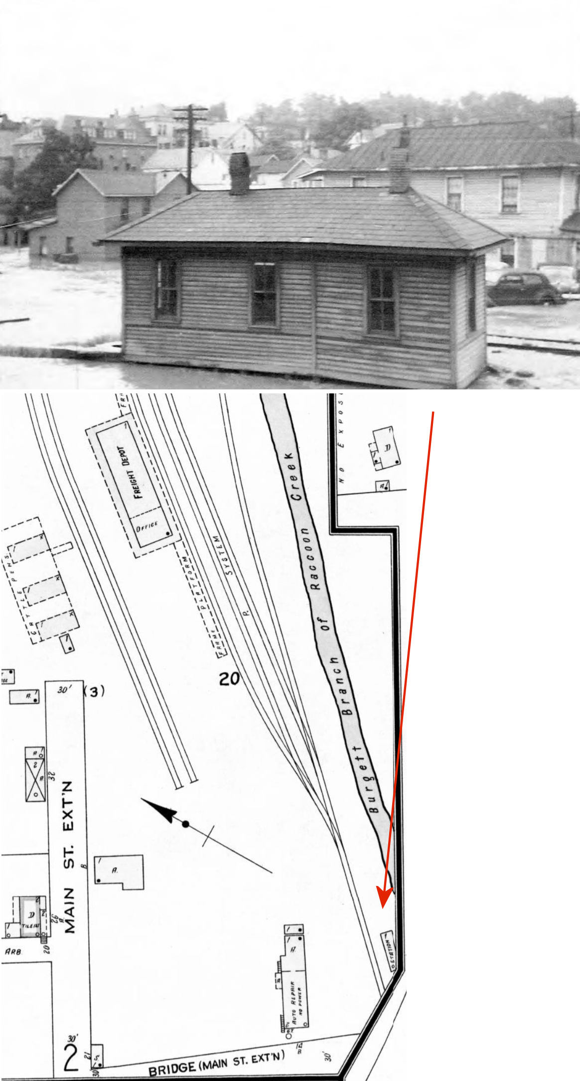
| Burgettstown |
|
This smaller station (or passenger shelter) was on the north side of Bridge Street along the west bank of the Raccoon Creek at GPS: 40.386722, -80.388313. It is shown on the 1925 Sanborn insurance map. | ||||||
| California | |
This was the original passenger station here, built in 1886. It was located at GPS: 40.068352, -79.889395. After the new station opened in 1910 it then served as the baggage pickup building. | ||||||
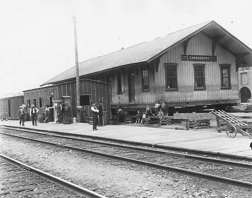
| Canonsburg | |
The original station was a Chartiers Valley RR station here that was built in 1871. It was located on the same site as the existing station at the corner of Murdoch Street and Jefferson Avenue (GPS: 40.257489, -80.188225). When the new brick station was planned, this station was moved to the west in 1907. Click here to read an excellent article by James T. Herron Jr. from the Jefferson College Times newsletter that details the history of the railroad and stations of Canonsburg. | ||||||
| Canonsburg | |
Between the time when the original station was moved to the west in 1907 and the new station was built in 1909, there was a small temporary depot, a baggage house (which was an old boxcar) and platform at the west end of the depot site as can be seen in the photo next to the old station which was being prepared for its move (GPS: 40.257321, -80.188678). | ||||||
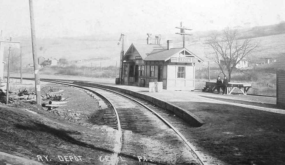
| Cecil |
|
This station is listed on the 1923 PRR List of Stations & Sidings on the Bridgeville & McDonald Branch between Gladden and Bishop. | ||||||
|
Cecil (Argyle) |
|
|||||||
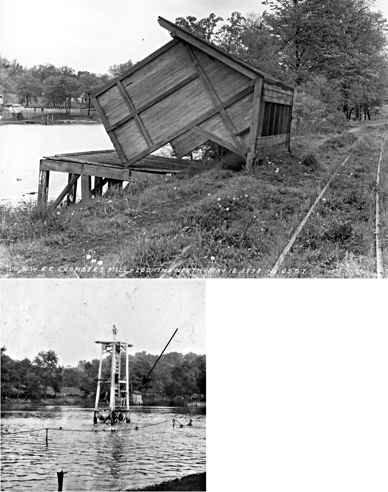
| Chambers Mill |
|
This shelter-type station was west of Banetown Road at approximately GPS: 40.096795, -80.241436 on the SE side of the lake. The station was on the west side of the tracks and actually was built on a platform that overhung the water. | ||||||
|
Charleroi (McKean Crossing) |
Pittsburgh Virginia & Charleston |
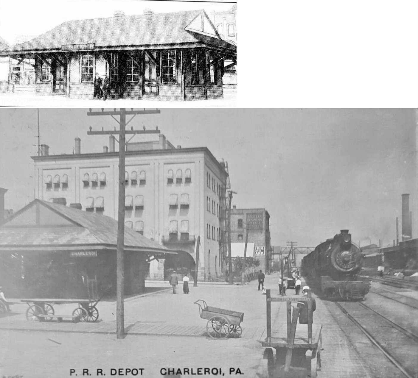
The first station here was on what is now 2nd Street at approximately GPS: 40.135736, -79.893704. It was on the McKean farm and was known as McKean Crossing or McKean Stop. The 16'x20' building was donated by the McKean family. According to the Mon City News (10-11-1890), in 1890 this station was moved to 5th Street and became the Charleroi station (not sure if it became the passenger or freight station). The 1894 map shows both passenger and freight stations of similar size at 5th Street. | ||||||
| Charleroi |
|
The second wood frame station here was on the SE side of 5th Street on the SW side of the tracks at GPS: 40.138541, -79.897083. It was built in 1891. | ||||||
| Charleroi |
|
The freight station was just to the SE of the passenger station at GPS: 40.138216, -79.896711. | ||||||
| Charleroi |
|
This brick passenger station was built at the same location as the original station on the SE side of 5th Street on the SW side of the tracks at GPS: 40.138541, -79.897083. It was built sometime between 1907-1913. | ||||||
| Charleroi |
|
A larger freight house was built sometime between 1897-1902. It was on the NW side of 4th Street at GPS: 40.137900, -79.896314. | ||||||
|
Charleroi (N. Charleroi) (Lock No. 4) (Monessen) |
|
This passenger station was on the north side of 4th Street on the west side of the tracks at GPS: 40.151326, -79.907119. A new station was built here in 1883. In 1909 this station was renamed "Monessen" as it was the PRR station that served that borough. At some point it may have also been known as West Monessen. | ||||||
| Chartiers Depot |
|
According to the 1876 atlas, this station was just west of Tunnel #6 in eastern Buffalo Township. | ||||||
| Cherry Valley |
|
This station is listed on the 1923 PRR List of Stations & Sidings at the end of the Hickory Branch. This line served the Pittsburgh & Eastern Colliery No.3 here. | ||||||
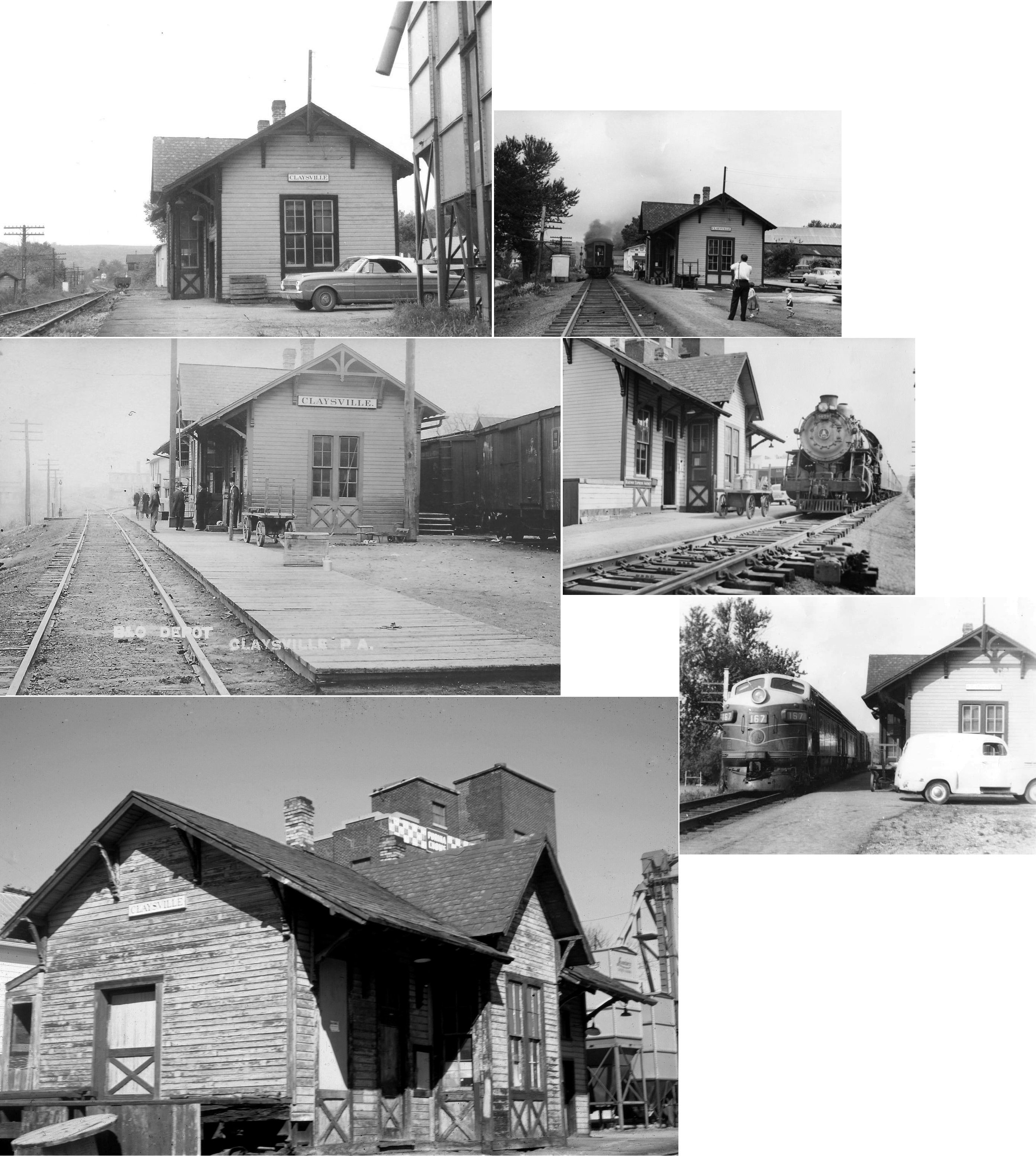
| Claysville | |
This station was on Railroad Street at Green Street at GPS: 40.116425, -80.412474. | ||||||
| Coal Bluff Station | |
This station was in the vicinity of PA-837 and Coal Bluff Road around GPS: 40.240328, -79.962601. It is shown on the 1884 map of the Monongahela River. The station was abandoned in October 1914. | ||||||
| Coal Centre | |
The passenger station was on the SE side of Spring Street on the north side of the tracks at GPS: 40.069877, -79.900200. The freight station was on the SE side of Strawberry Street at GPS: 40.069789, -79.899824. | ||||||
| Coffeys Crossing | |
|||||||
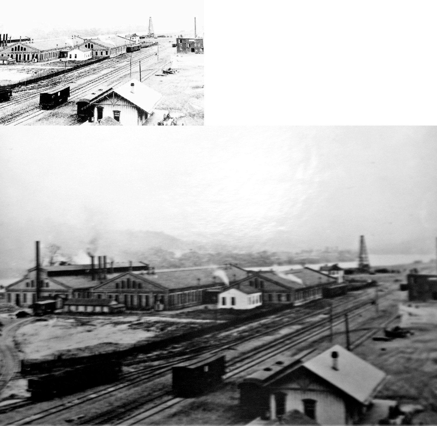
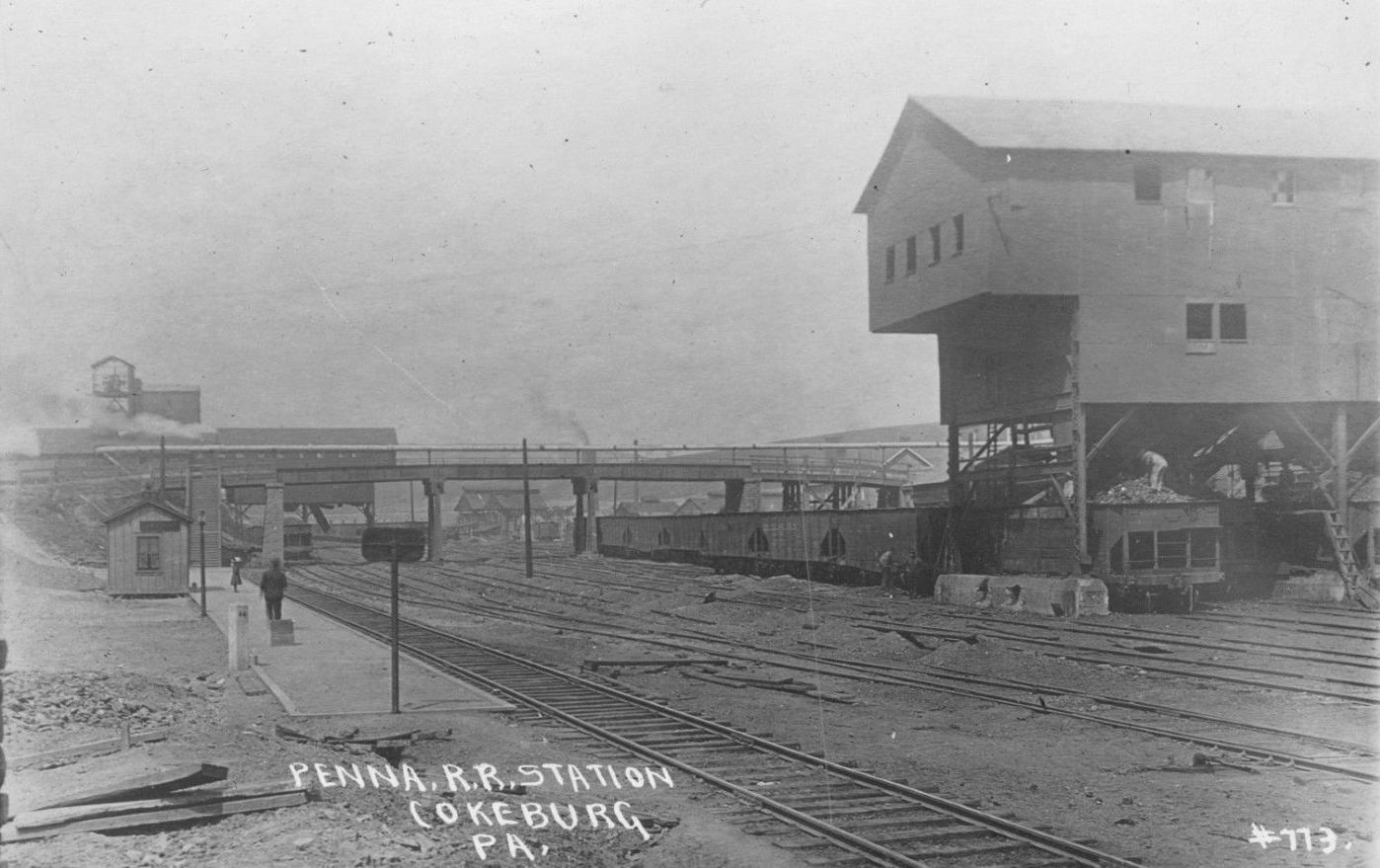
| Cokeburg (Ontario Jct.) |
|
This was the end of the Cokeburg Branch and is listed on the 1923 PRR List of Stations & Sidings. It was also the beginning of the short Ontario Branch. | ||||||
| Cokeburg Junction Station |
|
This was the beginning of the Cokeburg Branch at its junction with the Ellsworth Branch. This station is listed on the 1923 PRR List of Stations & Sidings. | ||||||
| Columbia |
|
This became the southern part of Donora. | ||||||
| Condits Crossing |
|
|||||||
| Conger |
|
|||||||
| Cook Station |
|
This early Chartiers Valley station was in the vicinity of Oak Grove Road on the NW side of Washington. | ||||||
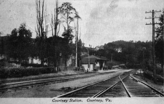
| Courtney |
|
A new station was built here in 1883. | ||||||
| Cowden |
 |
This station is shown on the 1923 timetable between Southview (George) and National. | ||||||
| Cracker Jack |
|
This station is listed on the 1923 PRR List of Stations & Sidings on the Ellsworth Branch. | ||||||
| Crothers Station |
|
This station was on Crothers Station Road off Sunset Beach Road at GPS: 40.150028, -80.370984. | ||||||
| Daniels Run |
|
This station is listed on the 1923 PRR List of Stations & Sidings on the Ellsworth Branch. | ||||||
| Denbo | |
This station is listed on the 1923 PRR List of Stations & Sidings and shown on the 1941 county map. The station was between two sidings that served the Relaince Coke Comapny. | ||||||
| Dinsmore |
|
The book "The History of The Panhandle" by Newton, Nichols and Sprankle published in 1879, says that the stations at Dinsmore, Hanlin and Paris Road were all within five miles of each other. | ||||||
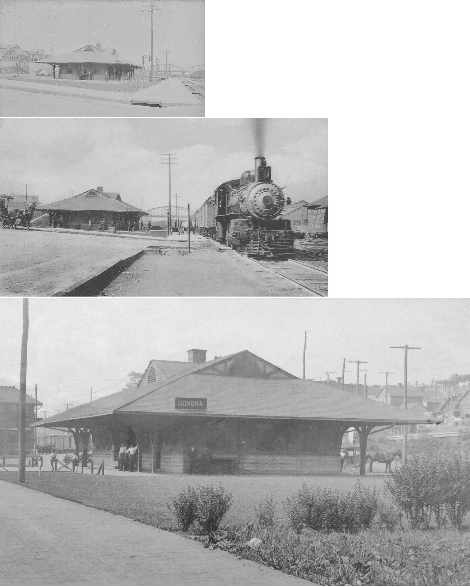
| Donora (Webster Sta.) |
|
A new station was built here in 1887. That station was on the south side of 8th Street on the east side of the tracks at GPS: 40.180551, -79.854318. The station name was changed from "Webster" to "Donora" in 1900 with the town of Donora incorporated in 1901. | ||||||
| Donora | |
A new brick station was built here in 1903. It was on the north side of 8th Street on the west side of the tracks at GPS: 40.180983, -79.854556. The station was built to the the same plan as the station built at Clairton the same year. | ||||||
| Donora | |
A new freight station was built here in 1903. It was a frame station with a two-story brick head end on the north side. It was on the south side of 8th Street on the West side of the tracks at GPS: 40.180459, -79.854626. | ||||||
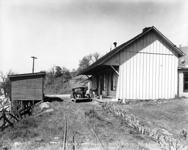
| Dunn (Dunns Station) |
|
|||||||
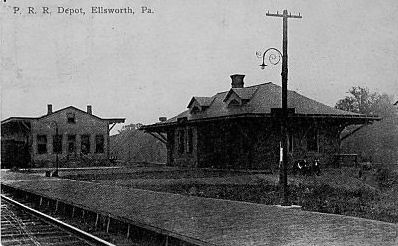
| Ellsworth | |
There was a passenger station and a freight station here. Both are listed on the 1923 PRR List of Stations & Sidings. | ||||||
| Elrama (Elben) |
|
This station is listed on the 1923 PRR List of Stations & Sidings. The station was known as Elben until 1907 (Pittsburgh Post Gazette, Nov. 10, 1907). It may have been called Hilldale previously as it is shown as such on the 1884 map of the Monongahela River. | ||||||
| Falkirk |
|
This station is listed on the 1923 PRR List of Stations & Sidings on the Westland Branch. | ||||||
| Fife |
|
This station was likely just a flag stop (without a structure) near the water tank that was here in railroad days. This location is between McMurray and Thompsonville in the general vicinity of GPS: 40.281707, -80.095123. | ||||||
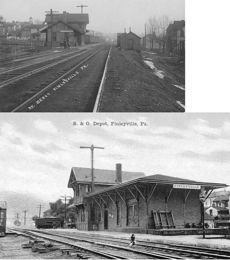
| Finleyville | |
This older station burned down in 1922 and was replaced with the station that still exists. | ||||||
| Finleyville | |
This second-generation depot was on Ann Street between Boyer Street and Brownsville Road (PA88) at GPS: 40.252395, -80.002060. It was torn down on January 14, 2026. | ||||||
| Fredericktown |
|
This station is listed on the 1923 PRR List of Stations & Sidings. | ||||||
| Frye |
|
This station is listed on the 1923 PRR List of Stations & Sidings on the Ellsworth Branch. | ||||||
| Geary |
|
This station is shown on the 1923 timetable between Steubenpike and McAdams. | ||||||
|
George (Southview) |
|
|||||||
|
George (Southview) |
|
This station is shown on the 1923 timetable between McDonald and Cowden. | ||||||
| Greymont |
|
This station is listed on the 1923 PRR List of Stations & Sidings on the Langeloth Branch between Sherlock and Studa. | ||||||
| Greenlee |
|
This station is listed on the 1923 PRR List of Stations & Sidings on the Ellsworth Branch. | ||||||
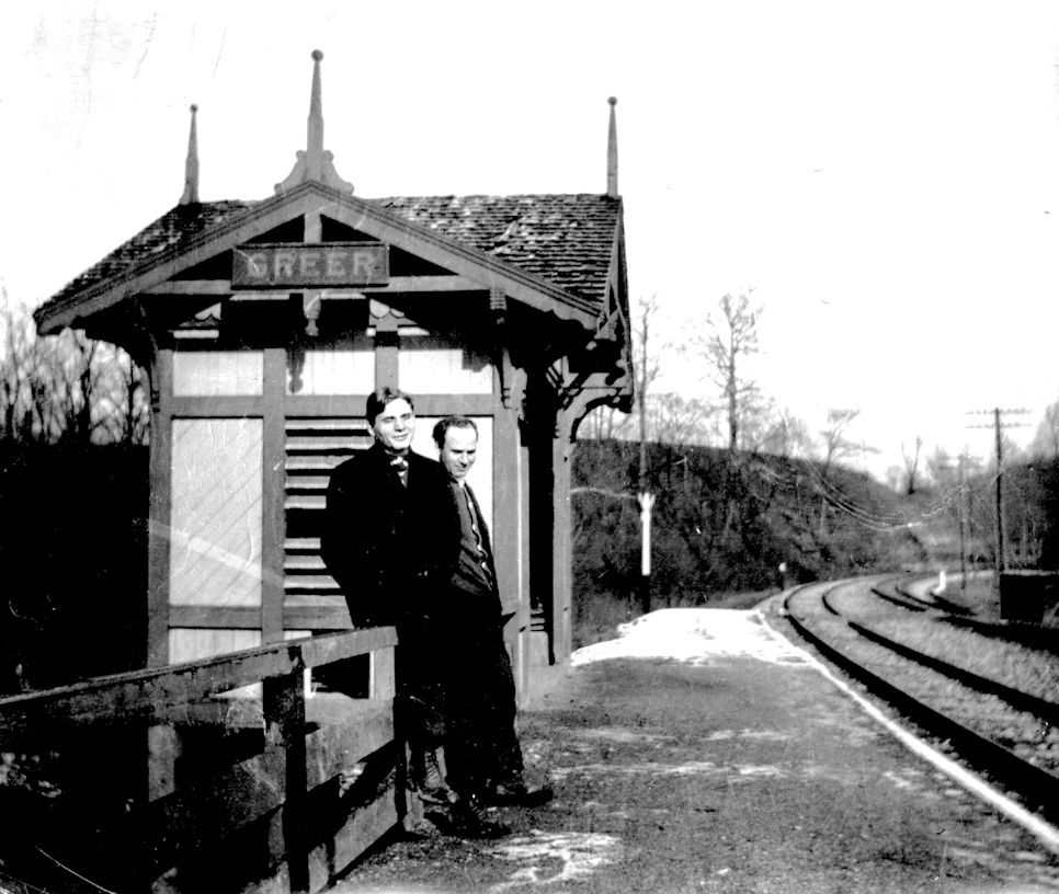
| Greer | |
|||||||
| Hackney | |
This is not the building that currently sits on SR2007 near the old grade (which looks like it could have been a station but isn't). The station was torn down in 1940 (The Daily Republican, 9-7-1940) and, prior to that, was used as a barn and storage shed by a private owner after the line ceased steam operations in 1933. After the station was torn down the lumber was used to build a sheep shed on a nearby farm. Hackney was the first station built on the line in 1877. That first station burned down due to a gas explosion in 1892 (The Pittsburgh Post, 3-2-1892) and the station listed and pictured here was built to replace that first station. | ||||||
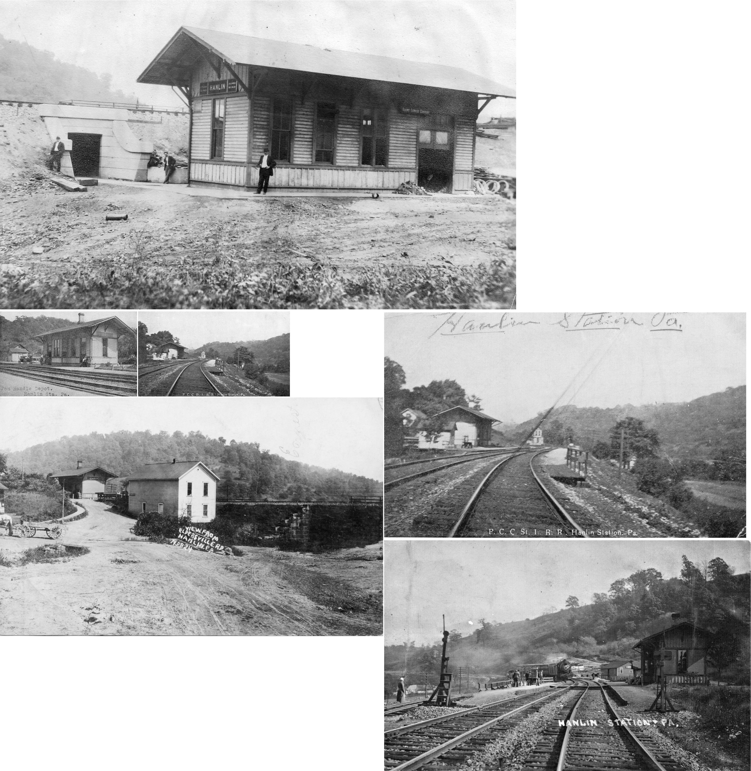
| Hanlin |
|
"IN" tower was near the station. It was off Hanlin Station Road (formerly Eldersville Road) at approximately GPS: 40.367735, -80.467381. | ||||||
| Hazel Kirk |
|
This station is listed on the 1923 PRR List of Stations & Sidings on the Ellsworth Branch. | ||||||
| Hendersonville |
|
This station is shown on the 1923 timetable between National and Hills (Hyland). | ||||||
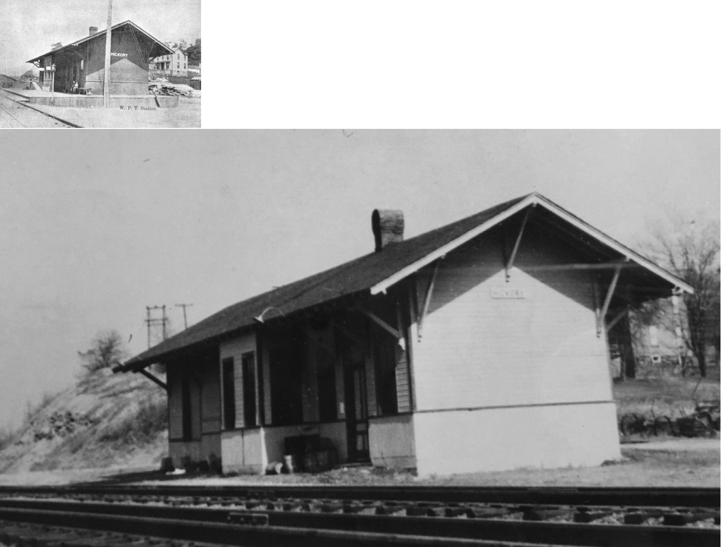
| Hickory | |
|||||||
| Hickton |
|
This station is listed on the 1923 PRR List of Stations & Sidings on the Hickory Branch. | ||||||
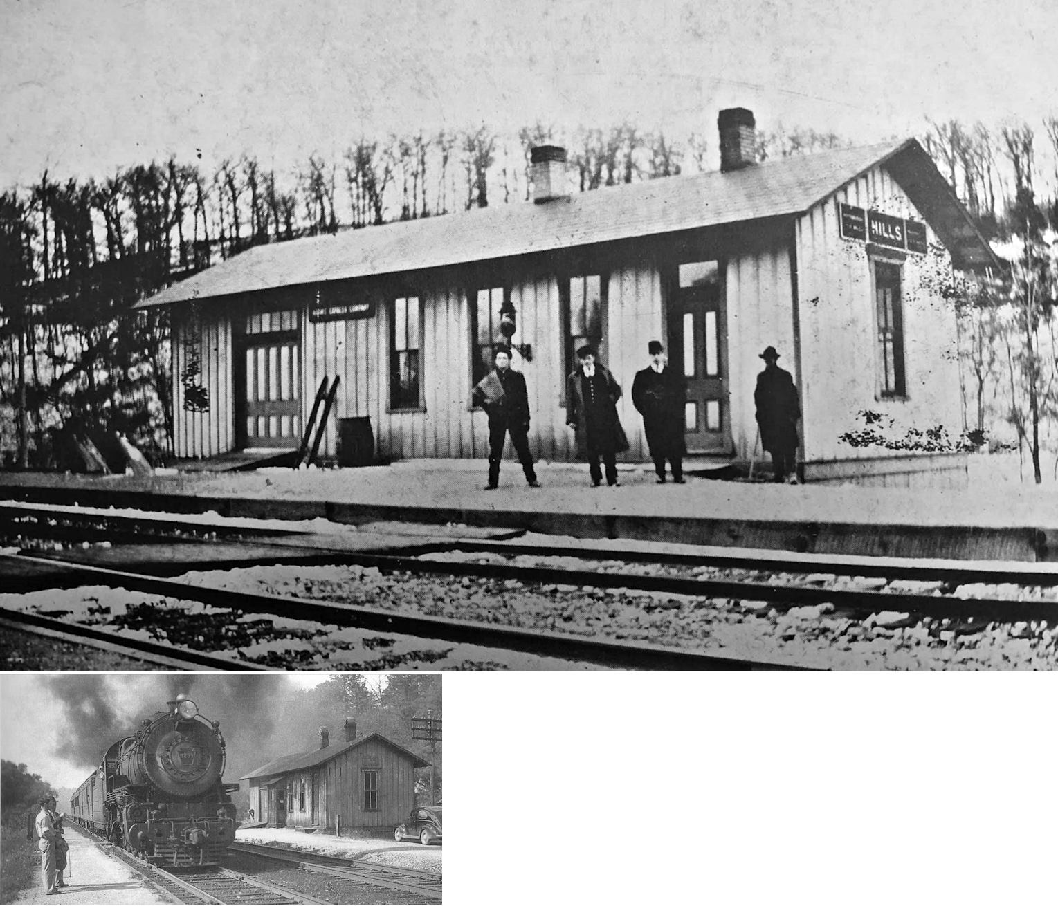
| Hills Station (Hyland) |
|
This station was near where Georgetown Road crosses the tracks in the SE part of Lawrenceville. A Chartiers Valley RR station is shown here on the 1876 map. In 1876 it was known as "Hills," but is shown on modern atlases as Hyland. This station is listed as "Hills" on the 1923 PRR List of Stations & Sidings on the Chartiers Branch. It was one mile from Tunnel No. 13. The station was likely demolished in the late 1950s. | ||||||
| Hills (Hyland) |
|
This station was near Montour Mine #4 in the vicinity of GPS: 40.297356, -80.109062. | ||||||
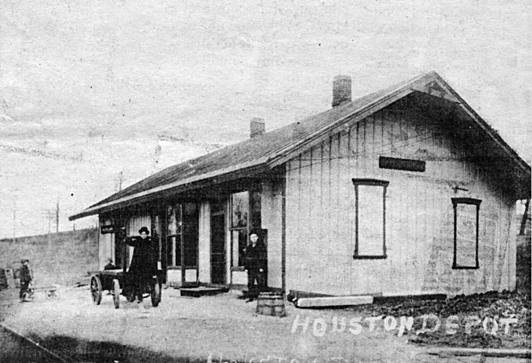
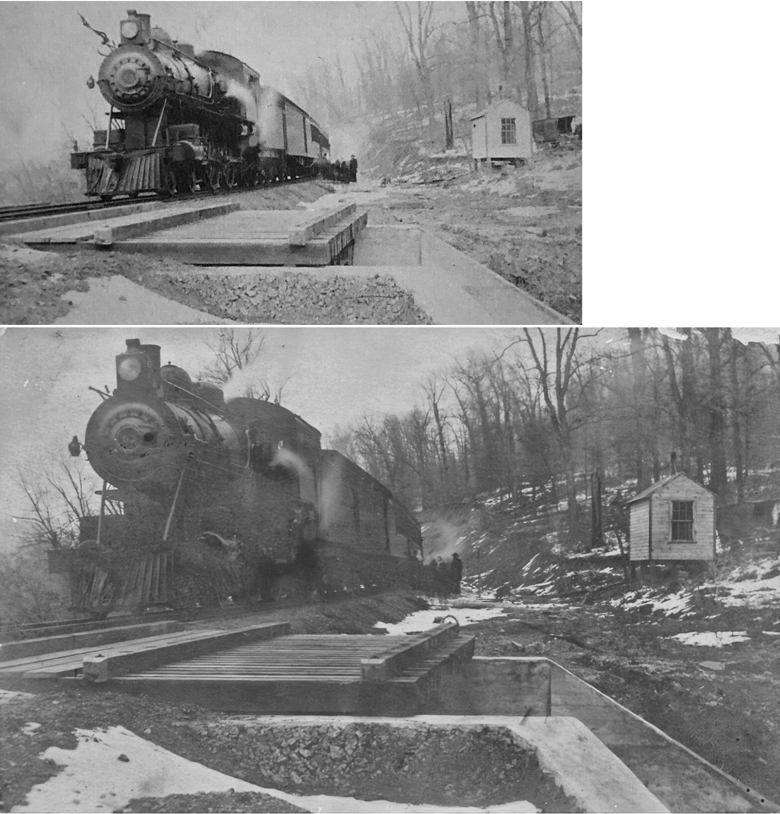
| Houston (Houstonville) |
|
In 1876 the Chartiers Valley station here was on the north side of Main Street on the east side of the tracks. | ||||||
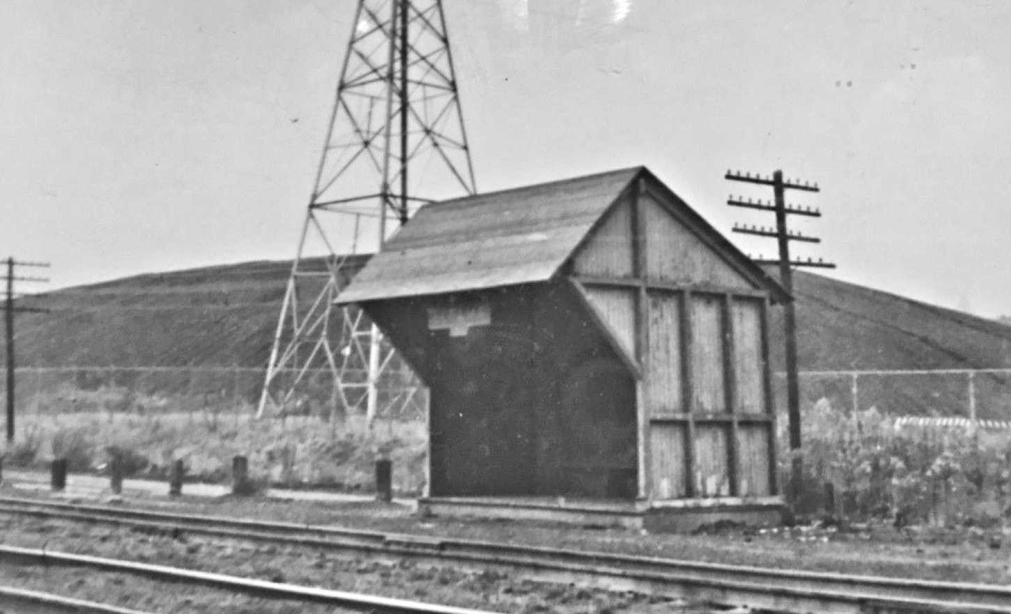
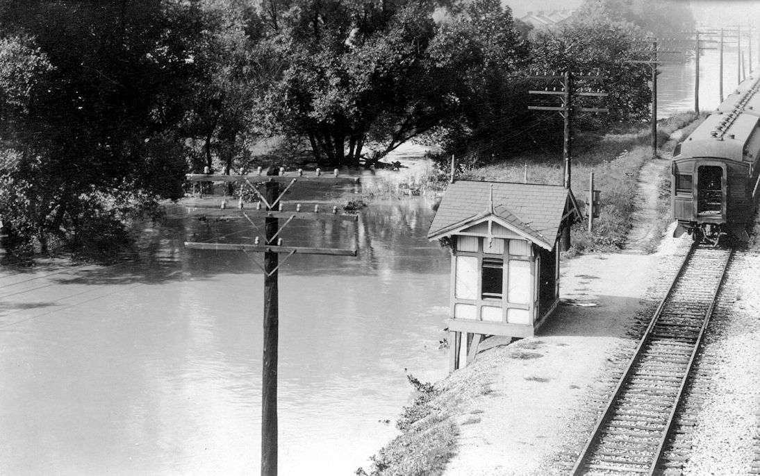
| Houston |
|
This shelter-type structure was at Houston, where the track to some
coal mines (called the Western Washington Railroad) left the Chartiers
Division mainline. The location is about a mile south of the
Canonsburg station (west in PRR parlance). The picture was taken
after/during a 1912 flood, and the Western Washington bridge over
Chartiers Creek probably was under water. The passenger cars probably
were there because the Canonsburg station was under water. You can see
a path along the passenger cars. Industry was at Canonsburg, and a
lot of men walked along the right-of-way to and from work. The plant
where radium was produced (and where Madam Curie visited) was only a
quarter-mile down the line, behind the cars standing there. Compare
this shelter with the one at Greer. Perhaps this shelter had a name,
but Sanborn maps don't show this area and no map could be found (yet)
showing this buiilding. The 1927 Sanborn map indicates that the
main station was on the
south side of Main Street on the east side of the tracks at GPS:
40.248268, -80.206295.
|
||||||
| Hunts Station |
|
This was a station on the Chartiers Valley RR as shown on the 1876 map. This may be the same station as Houston as it was in that area but on the east side of the river. | ||||||
| Huston Run station |
|
This station was four miles NW of Monongahela where PA837 junctions with Huston Run Road at approximately GPS: 40.231970, -79.972367. It is shown on the 1884 map of the Monongahela River. | ||||||
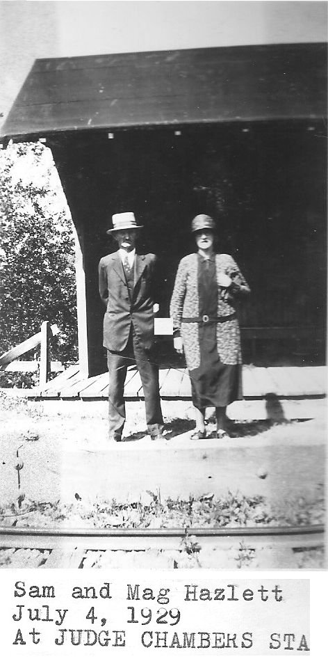
| Judge Chambers Station |
|
A small waiting shelter was here. | ||||||
| Langeloth |
|
This station was on Townsite Street (formerly Main Street) just north of Eleanor Street at GPS: 40.360714, -80.407514. It is listed on the 1923 PRR List of Stations & Sidings on the Langeloth Branch which ran from Vanlear to the Knox Colliery near Studa. | ||||||
| Library Junction |
|
This station is shown on the 1923 timetable between McMurray and Library. | ||||||
| Lock No. 4 Station |
|
See listing above for Charleroi/North Charleroi. | ||||||
| Lucyville |
|
See entry for Roscoe below. | ||||||
| Luellen |
|
This would have been a very early station on the line. Luellen has not been a town since the early 1900s, if it was ever a town at all. No sign of rails in the area at all. It was in the vicinity of GPS: 40.054995, -80.235780. | ||||||
| Mancha |
|
This station is listed on the 1923 PRR List of Stations & Sidings on the Cokeburg Branch. | ||||||
| Maple Glen |
|
This station is listed on the 1923 PRR List of Stations & Sidings. | ||||||
| Marbury |
|
This station is listed on the 1923 PRR List of Stations & Sidings on the Langeloth Branch. | ||||||
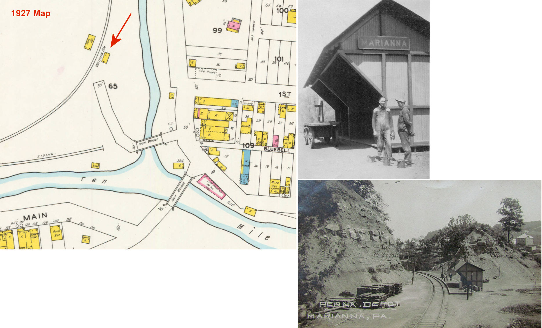
| Marianna (Zollarsville) |
|
There was a passenger shelter here located on the west side of Daniels Run at approximately GPS: 40.025344, -80.089641. This was the last station on the Ellsworth Branch which ended about 1/2 mile south of the station. | ||||||
| Mc Connells Mills |
|
This station is listed on the 1923 PRR List of Stations & Sidings on the Westland Branch. | ||||||
| McCoy |
|
This station was between Acheson and Hickory. | ||||||
| McAdams |
|
This station is shown on the 1923 timetable between Geary and McDonald. | ||||||
| McCracken |
|
There was a shelter-type station here. | ||||||
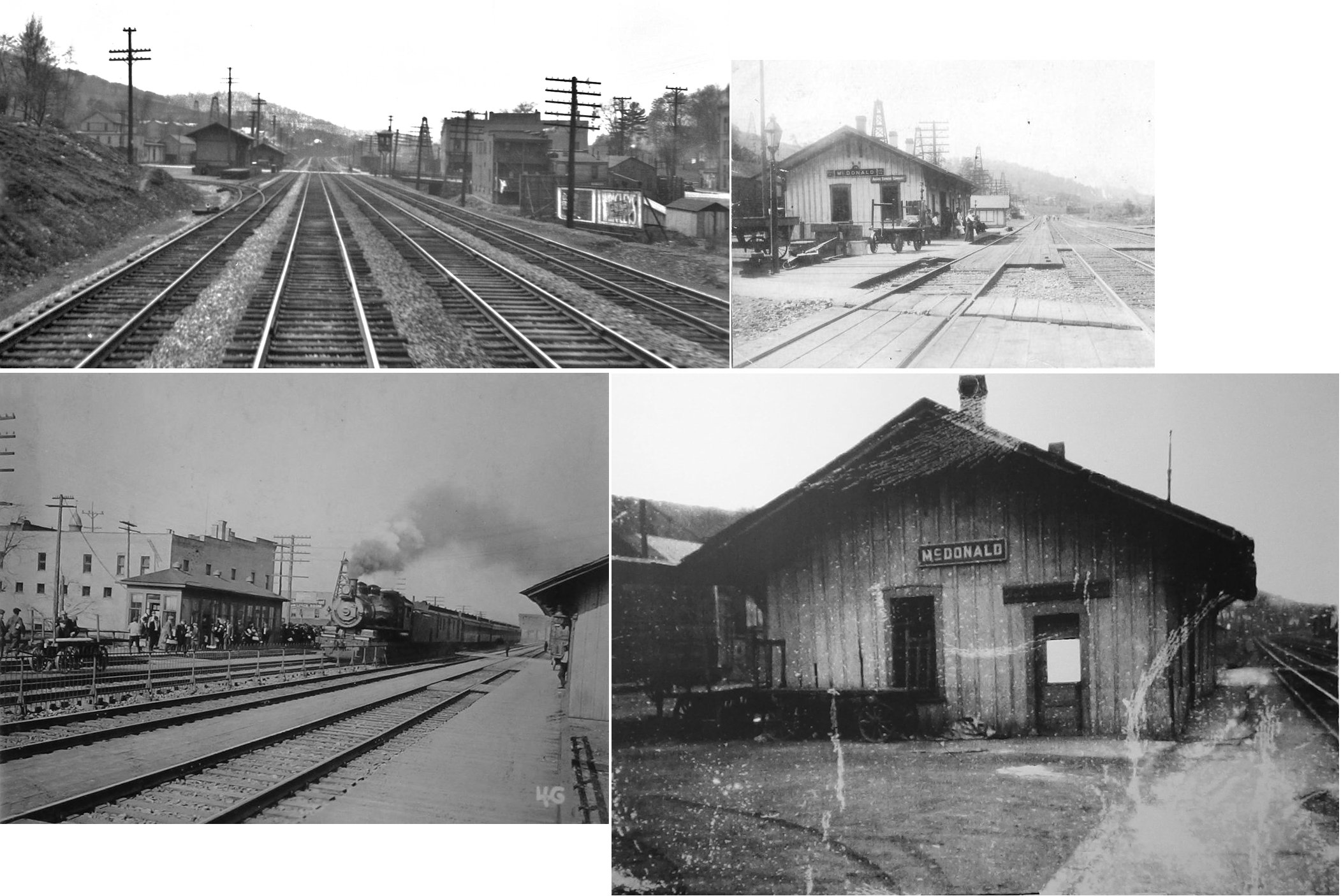
| McDonald |
|
The passenger and freight station were on the south side of the tracks. The passenger station was on the west side of McDonald Street (at GPS: 40.366967, -80.235268), while the freight station was on the east side (at GPS: 40.367184, -80.234766). In the early years, there was a long woodedn platform across the tracks from the passenger station. This platform was accessed from a bridge over the creek that extended from a 2-story wooden commercial building at the NE end of Station Street. The building contained the post office as well as a telegraph office and some shops. Later it was just a large general store. That building burned down sometime between 1902-1908 and was replaced with the brick building that is there now. The platform was removed and a passenger waiting shed was installed across from the station with a small footbridge over the creek at the end of Station Street. | ||||||
| McDonald |
|
This station is shown on the 1923 timetable between McAdams and Southview (George). | ||||||
| McGugin |
|
|||||||
| McMurray |
|
This station was near the East McMurray Road crossing at approximately GPS: 40.278407, -80.084424. | ||||||
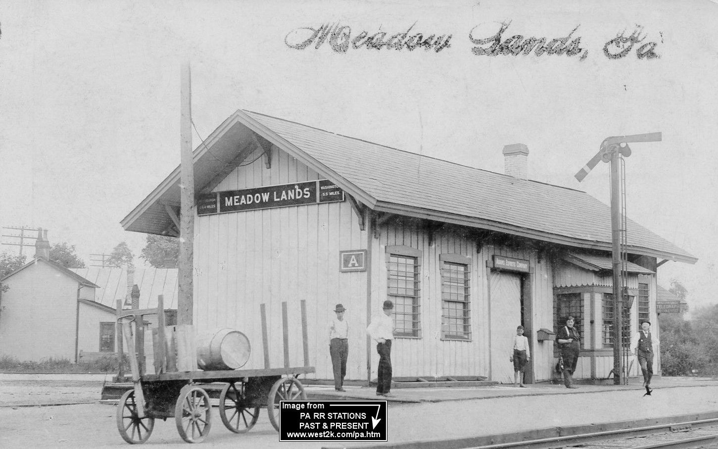
| Meadowlands (Ewings Mills) |
|
This station in shown on the 1876 county atlas as Ewing Station. | ||||||
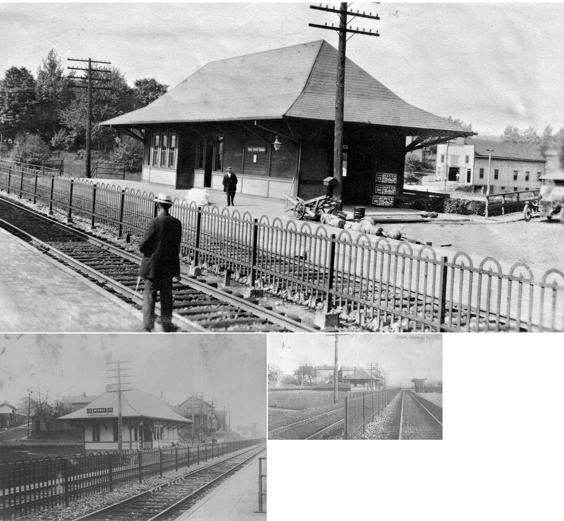
| Midway |
|
This town was named as such due to the fact that it was midway between Pittsburgh and Steubenville. The station was on the west side of Main Street on the north side of the tracks at GPS: 40.368333, -80.289941. | ||||||
| Millsboro |
|
This station is listed on the 1923 PRR List of Stations & Sidings. It was west of what is now Front Street at approximately GPS: 39.986833, -79.995549. This was 2/10th of a mile from the beginning of the Ten Mile Run Branch. | ||||||
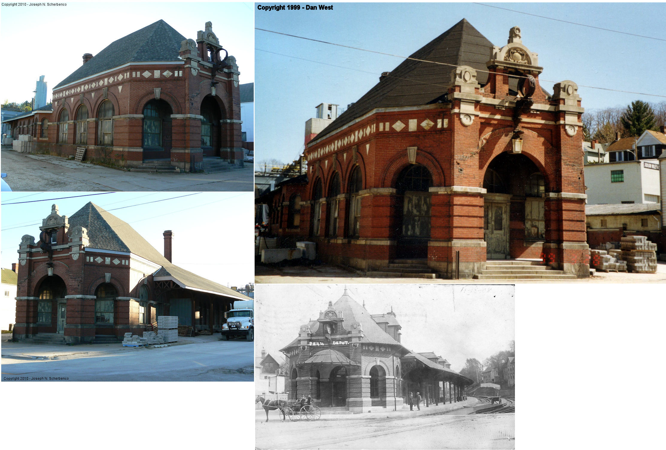
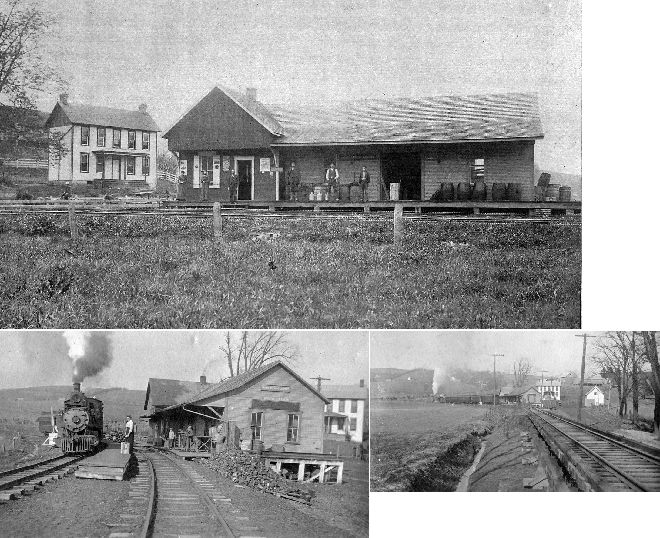
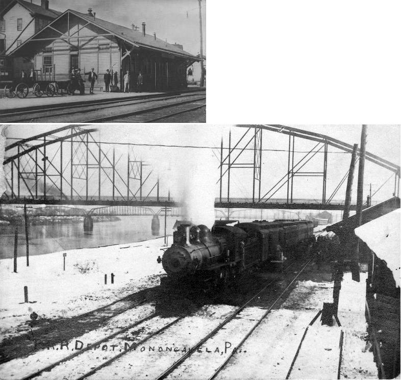
| Monongahela | |
The passenger station was on Railroad Street on the SE side of 2nd Street at GPS: 40.201956, -79.923524. This station was built in 1883. | ||||||
| Monongahela | |
The first freight station was on Railroad Street on the NE side of the tracks at GPS: 40.202845, -79.924274. A new freight station was built between 1886-1895. The new freight station was across 2nd street from the passenger station at GPS: 40.202175, -79.923766. | ||||||
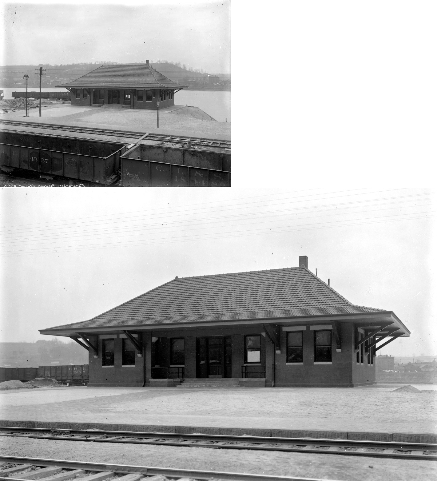
| Monongahela |  |
This station was across the river in Allegheny County. It sat to the NE of the PA136 bridge (GPS: 40.201129,-79.915854). This was likely the original passenger station and was then used for freight after the new brick station was built. | ||||||
| Monongahela | |
This appears to be a more modern passenger station. | ||||||
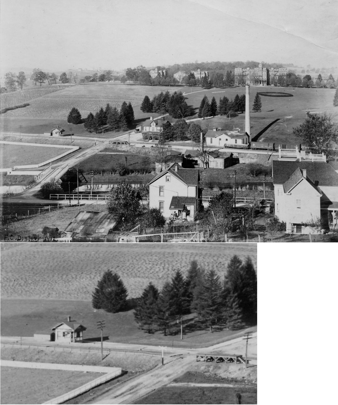
| Morganza | |
This station served the old Pennsylvania Training School at Morganza (a reform school that was just outside Canonsburg). It was located on Curry Hill Road at GPS: 40.270414, -80.162888. | ||||||
| Morganza | |
This may have been a later station built here. | ||||||
| Mt. Herman |
|
There was a standard shelter station here. It was gone by 1938. | ||||||
| National |
|
This station is shown on the 1923 timetable between Cowden and Hendersonville. | ||||||
| New Eagle (Bellewood) |
|
|||||||
| Nukoal |
|
This station was between Sugar Camp Road and Bebout Road in Peters Township northeast of McMurray in the vicinity of GPS: 40.281943, -80.066539. | ||||||
| Oak Grove (Morgan's Crossing) |
|
This station was between Arden and Tylerdale. | ||||||
| Palanka |
|
This station was at milepost 1.4 of the Palanka Branch which began at Houston and ended at milepost 1.7. | ||||||
| Paris Road (PAris Crossing) |
|
The book "The History of The Panhandle" by Newton, Nichols and Sprankle published in 1879, says that this was the last station before the Panhandle entered West Virginia. It was near the intersection of Creek Lane Road and Bartleyville Road. | ||||||
| Penowa |
|
This was the last station before the line crossed into West Virginia. | ||||||
| Primrose |
|
An earlier station here burned down in 1903. | ||||||
| Primrose |
|
This station was built in 1904 according to the PCC&St.L Annual Report of that year. | ||||||
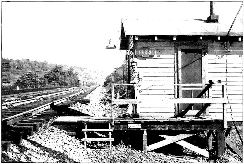
| Raccoon (Joffre) |
|
This station was on Station Street at approximately GPS: 40.382093, -80.360216. It was probably torn down in the mid 1960s. A new freight station was built here in 1904 according to the PCC&St.L Annual Report of that year. | ||||||
| Rea |
|
This station was between Woodrow and West Middletown. | ||||||
| Redds Mill |
|
This station is listed on the 1923 PRR List of Stations & Sidings on the Ellsworth Branch. | ||||||
| Richfol |
|
This station was between Morganza and Canonsburg. | ||||||
| Ringland |
|
|||||||
| Riverview |
|
This station was between Courtney and New Eagle. | ||||||
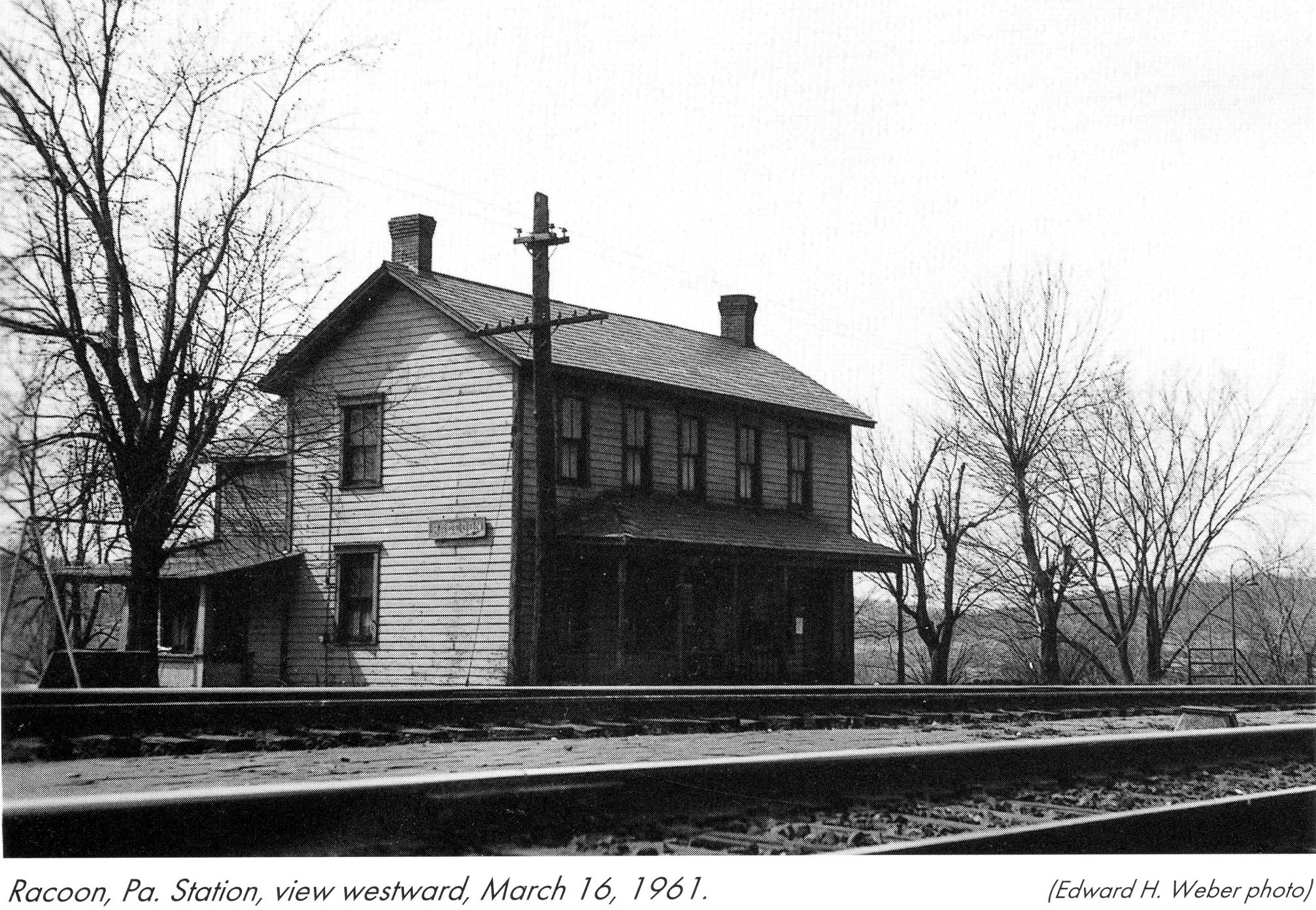
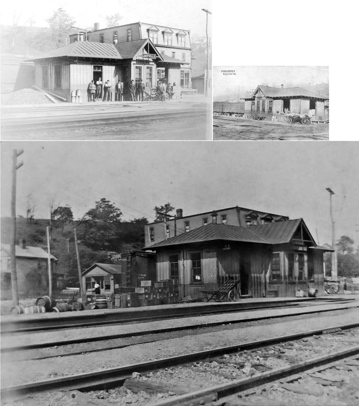
| Roscoe (Lucyville) |
|
A new station was built here in 1885. The town was originally known as Lucyville. The station was on the west side of Howard Street on the north side of the tracks at GPS: 40.079579, -79.865684. | ||||||
| Roscoe | |
Either a new station was built here sometime between 1911-1925 or the original station was moved a bit to the west. The 1925 Sanborn map appears to show a larger station a few feet to the west of where the original depot was on the 1911 map. The borough was originally known as Lucyville, but the name was changed in 1894 when it was incorportaed. The station's name didn't change to Roscoe until 1908. | ||||||
| Scenery Hill Station |
|
This station is listed on the 1923 PRR List of Stations & Sidings on the Ellsworth Branch. It was along Station Road/Hog Head Lane. | ||||||
| Sherlock |
|
This station is listed on the 1923 PRR List of Stations & Sidings on the Langeloth Branch. | ||||||
| Shingiss (Johnson) |
|
Prior to 1895, this station was known as Johnson. | ||||||
| Shire Oaks |
|
This station is listed on the 1923 PRR List of Stations & Sidings. In October 1914 this station and the nearby Coal Bluffs station were closed and the PRR opened a new Shire Oaks station about 1/4 mile south of the old station. | ||||||
| Slovan |
|
This station was at milepost 2.6 at the end of the Burgetts Branch according to the 1923 PRR List of Stations & Sidings. | ||||||
| Southview |
|
See listing above for "George." | ||||||
| Southview |
|
See listing above for "George." | ||||||
| Stockdale |
|
This station is listed on the 1923 PRR List of Stations & Sidings. | ||||||
| Studa | |
This was the end of the 6.6 mile Langeloth Branch that branched off at Vanlear. The station was at milepost 6.2 and the end of the branch was near the Knox Colliery at milepost 6.6. | ||||||
| Sudan Station |
|
This station is not listed on the 1923 PRR List of Stations & Sidings, but is shown on the 1941 county map. | ||||||
| Summit |
|
A small waiting shelter was here. This was between Judge Chambers Station and Braddock. | ||||||
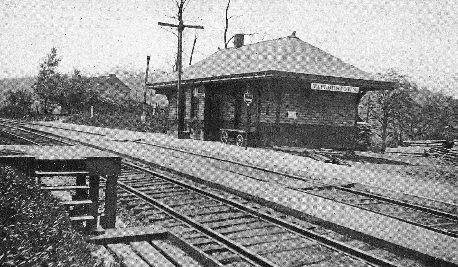
| Taylorstown Station | |
Also known as Crother's Station, this depot sat across from the post office on a side road off SR3009. | ||||||
| Thompsonville | |
This station was likely near where Washington Road crossed the tracks. | ||||||
| Tylerdale | |
|||||||
| Valear |
|
This station was at milepost 1.5 of the Burgetts Branch according to the 1923 PRR List of Stations & Sidings. The Langeloth Branch also began here. Valear was between Burgettstown and Slovan. | ||||||
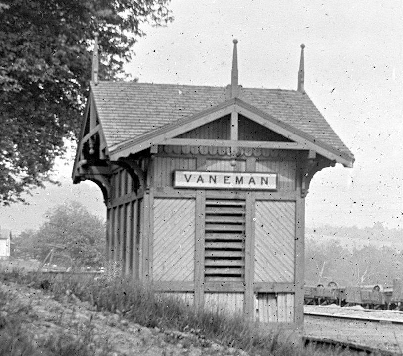
| Van Eman | |
This was a station on the Chartiers Valley RR. There is an old grade going south from here. This was the "Chartiers Southern" which started at Van Eman through Eighty Four, to Glyde (where a tunnel is) down to the PRR Marianna Branch. The B&O was supposed to have owned the Chartiers Southern from Eighty Four to Marianna, even though no physical connection existed in between the two railroads. The line was started South from Van Eman in 1908, but was abandoned in 1917 having never been completed. | ||||||
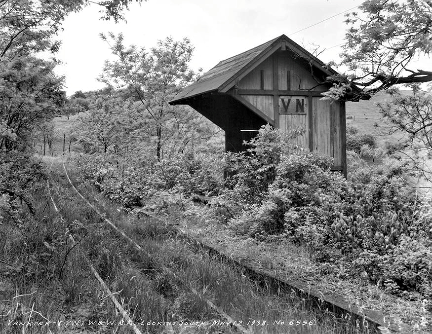
| VanKirk |
|
|||||||
| Van Voorhis (Old Patch) |
|
This station is listed on the 1923 PRR List of Stations & Sidings on the Ellsworth Branch. There was a shelter-type station here. | ||||||
|
Venice (Gwendolen) |
|
|||||||
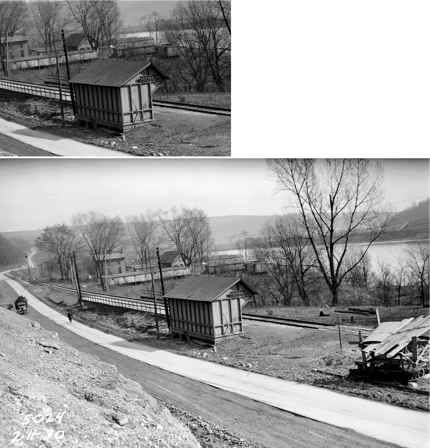
| Vestaburg |
|
This station is listed on the 1923 PRR List of Stations & Sidings. | ||||||
| Vestaburg |
|
|||||||
| Washington |
|
This was the original passenger station which was built in 1884 and served until the newer brick station was built. | ||||||
| Washington |
|
The passenger station was on the north side of West Chestnut Street at Washington Street just in front of the existsing freight station (GPS: 40.171715, -80.253875). | ||||||
| Washington | |
The original B&O freighthouse here burned in 1887 and was replaced in 1888. | ||||||
| Weaver |
|
This station is listed on the 1923 PRR List of Stations & Sidings on the Ellsworth Branch. | ||||||
| Webster Station |
|
See listing above for Donora. | ||||||
| West Alexander | |
|||||||
| West Belle Vernon |
|
|||||||
| West Brownsville |
|
In 1888 the passenger station was just west of Bridge Boulevard on the south side of the tracks (GPS: 40.023938, -79.890972). It appeared to be a part of a block of buildings rather than a traditional stand-alone station. This block of buildings included a grocery store and several dwellings. This station appears on several maps through 1901. | ||||||
| West Brownsville |
|
On the 1907 map, a new station appears in approximately the same location as the one listed above. This station, however, is not attached to any other buildings. This may have been the previous station just remodeled and relocated (turned) a bit to orient it in line with the tracks. The 1899 PRR Annual Report says that a brick building at West Brownsville was remodeled for use as a station. | ||||||
| West Brownsville Junction |
|
This station was the beginning of the Redstone Branch which corssed the river into Fayette County. The station was in the general vicinity of GPS: 40.034284, -79.879804. | ||||||
| West Columbia |
|
This station is listed on the 1923 PRR List of Stations & Sidings. | ||||||
| West Middletown |
|
|||||||
| West Monessen |
|
This station is listed on the 1923 PRR List of Stations & Sidings. It may be the same station as North Charleroi listed above under the listings for Charleroi. | ||||||
| Westland |
|
The Westland Branch went from Houston to Westland via Brevard. This station is listed on the 1923 PRR List of Stations & Sidings on the Westland Branch. The station was at milepost 4.6 nd the end of the Westland Branch was at milepost 5.3. | ||||||
| Woodrow |
|
|||||||
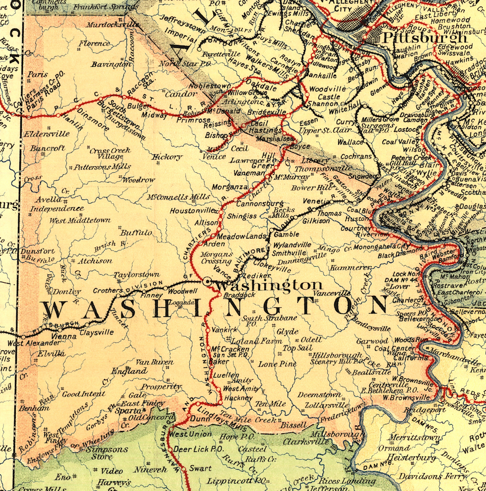
| 1895 WASHINGTON COUNTY RAILROAD MAP | ||||||||
 |
||||||||
| Notes About Existing
Stations... Avella (P&WV) - Restored by A.D. White Research Society. See restoration photos at their site. Burgettstown (Replica) - The original PRR station at this site was torn down around 2009 and a replica of the station in its original configuration was erected. Some wood and windows from the original station were used to construct the replica. California (PRR) - On National Register of Historic Places. Caboose also on site. Became the library in 1958. Washington (B&O) - The tracks don't see much action anymore besides an almost daily local which wanders down in the evening from Pittsburgh. In 1986, CSX ripped out around 15 miles of track between Wheeling, WV and Claysville, PA, severing the tracks which were once the farthest west in the USA. Station was designed by E F Baldwin. It cost $9,794. According to the B&O Annual Report of 1888, the station was built in that year. Washington (W&W) - Used by Judson and Wiley for storage. It was built for the narrow gauge Waynesburg and Washington railroad back in the 1920's. After the Pennsylvania RR bought out the W&W, the tracks by the station were dual-gauged for a while. The station has beautiful stonework, but it is not in really good shape now. A supply and cement company uses the building for storage, and cement trucks drive down where the tracks were. The tracks were last used in the late 70's/early 80's when Conrail would deliver hoppers to the supply company. West Brownsvile (PRR) - "Train Station Auto." Covered with aluminum siding. This may be the original freight station as the 1886 map shows the freight station at this same location. |
||||||||