|
|
||||||||
| EXISTING STATIONS | ||||||||
|---|---|---|---|---|---|---|---|---|
| Station Name |
Original Railroad |
Current Location |
Type | Current Use |
Date Built |
Track Status |
Building Material |
More Info |
| Drake Well |  |
Museum Lane at the Drake Well Museum (GPS: 41.612713, -79.656408) |
P | Railroad | 1987 | In Use | Wood | |
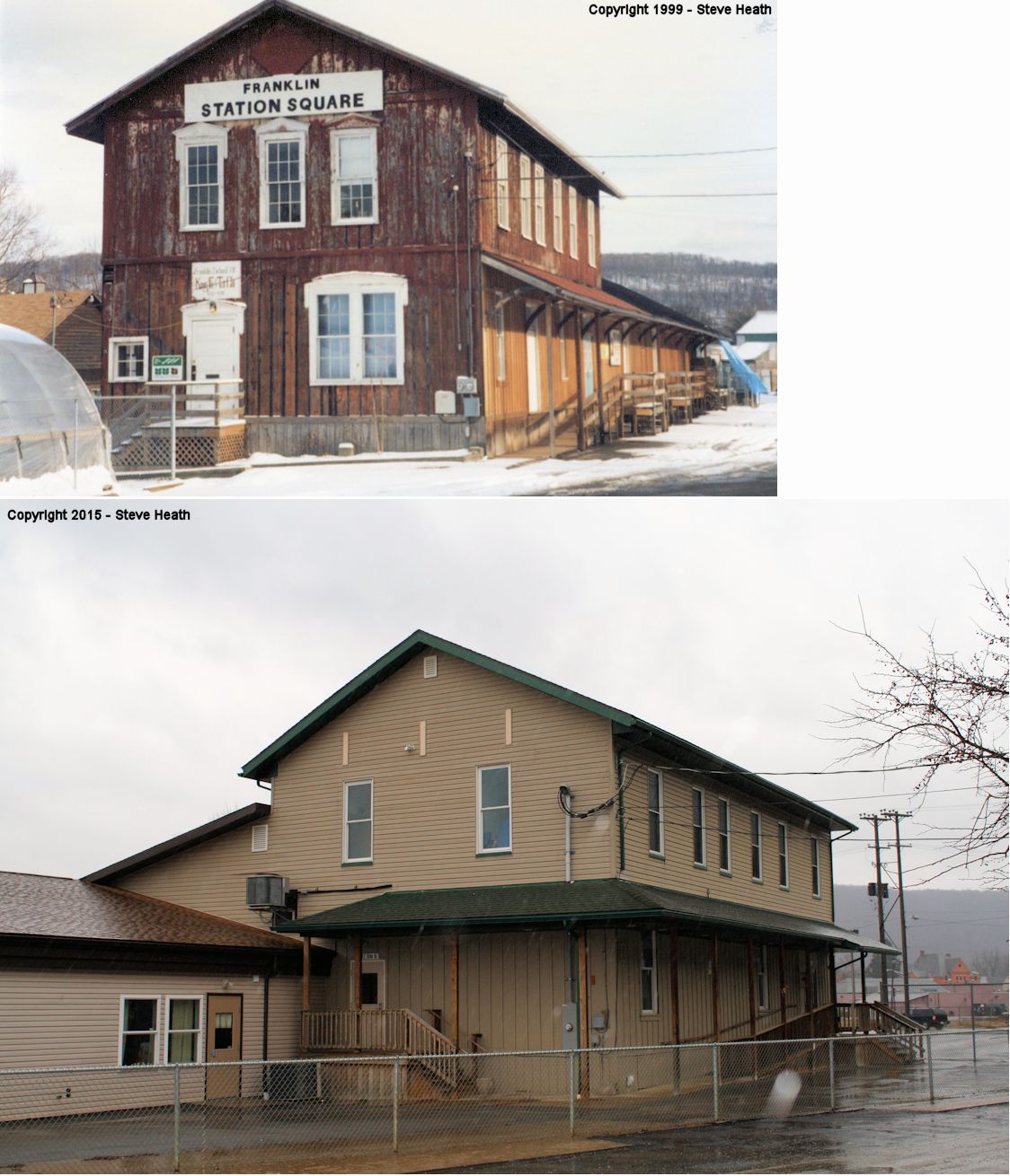
| Franklin |  |
1215 Railroad Street (GPS: 41.394969, -79.831505) |
P | Vacant | 1901 | Gone | Brick | |
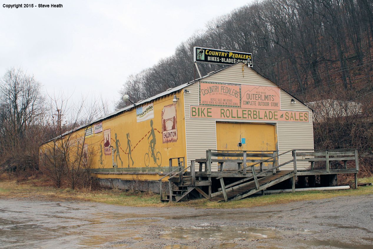
| Franklin | |
Elm Street between 11th and 12th Streets (GPS: 41.394241, -79.830501) |
F | Business | 1867 | Gone | Wood |
|
| Franklin Station |
 |
East end of US 322 bridge, across Allegheny River from Franklin (GPS: 41.388933, -79.817413) |
F | Business | ???? | Gone | Wood |
|
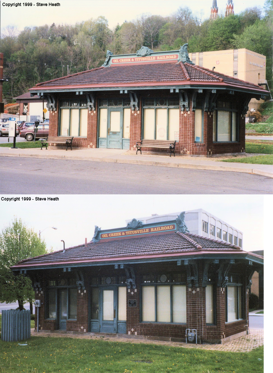
| Oil City | |
East side of Elm Street (GPS: 41.433348, -79.707415) |
P | Railroad | ???? | In Use | Brick |
|
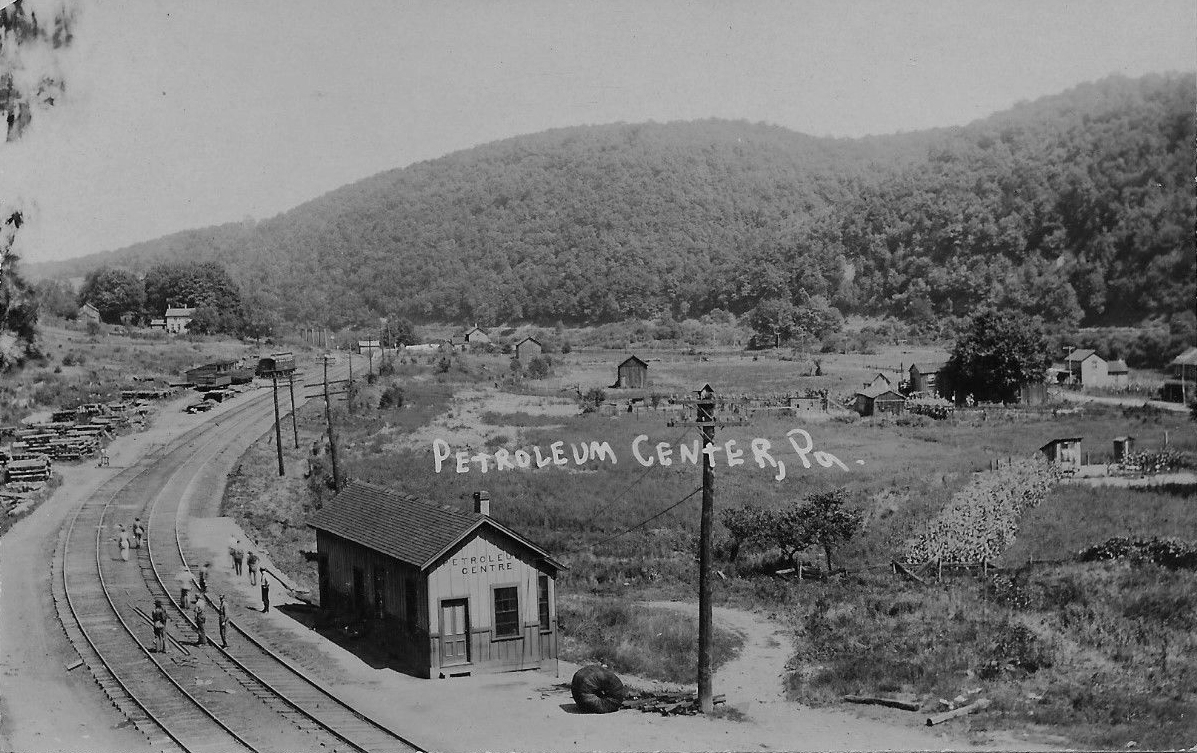
| Petroleum Centre |
|
Old Petroleum Center Road in Oil Creek State Park (GPS: 41.518316, -79.683183) |
P | Railroad | 1988 | In Use | Wood | |
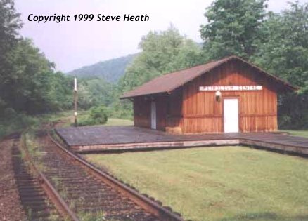
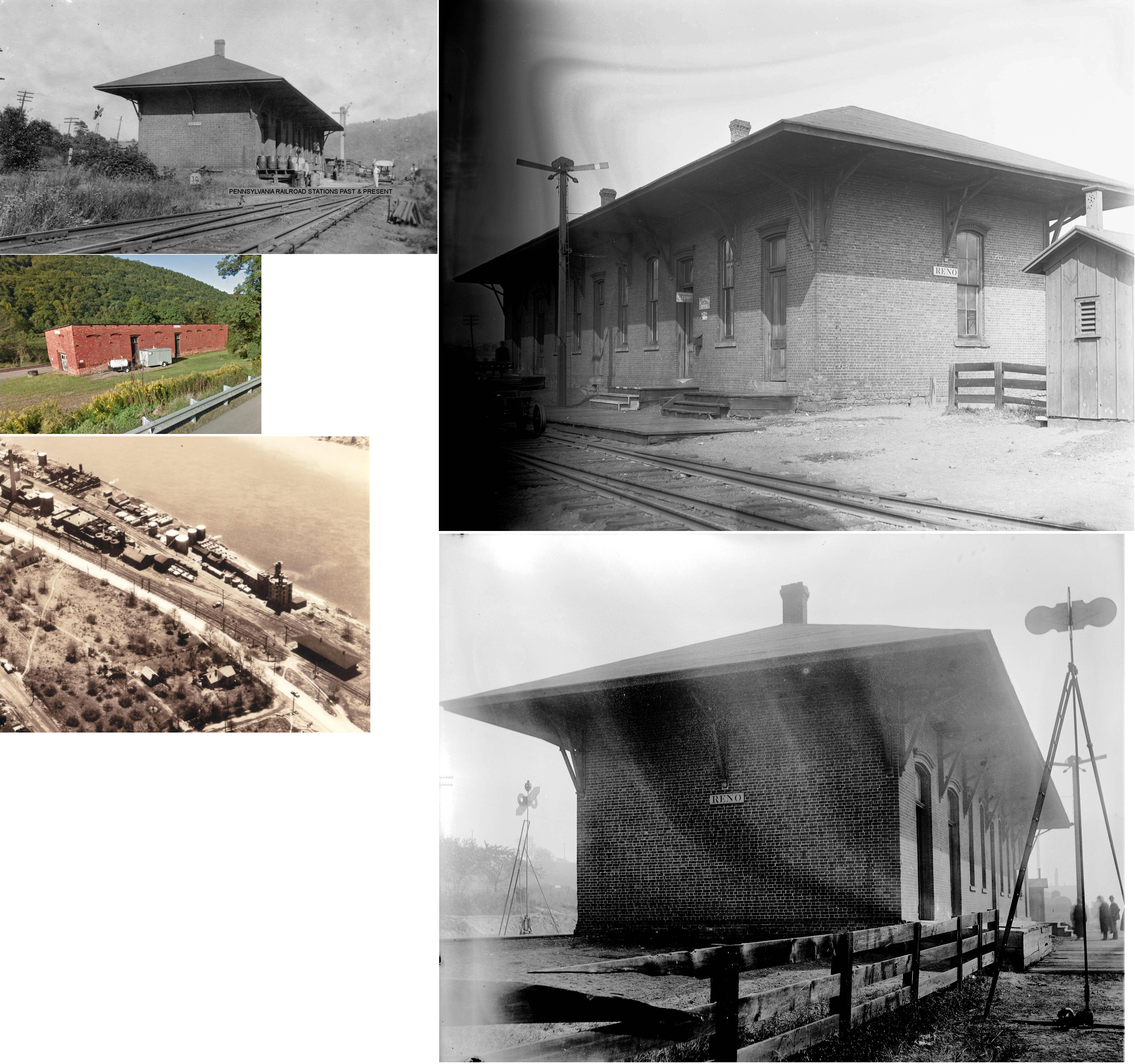
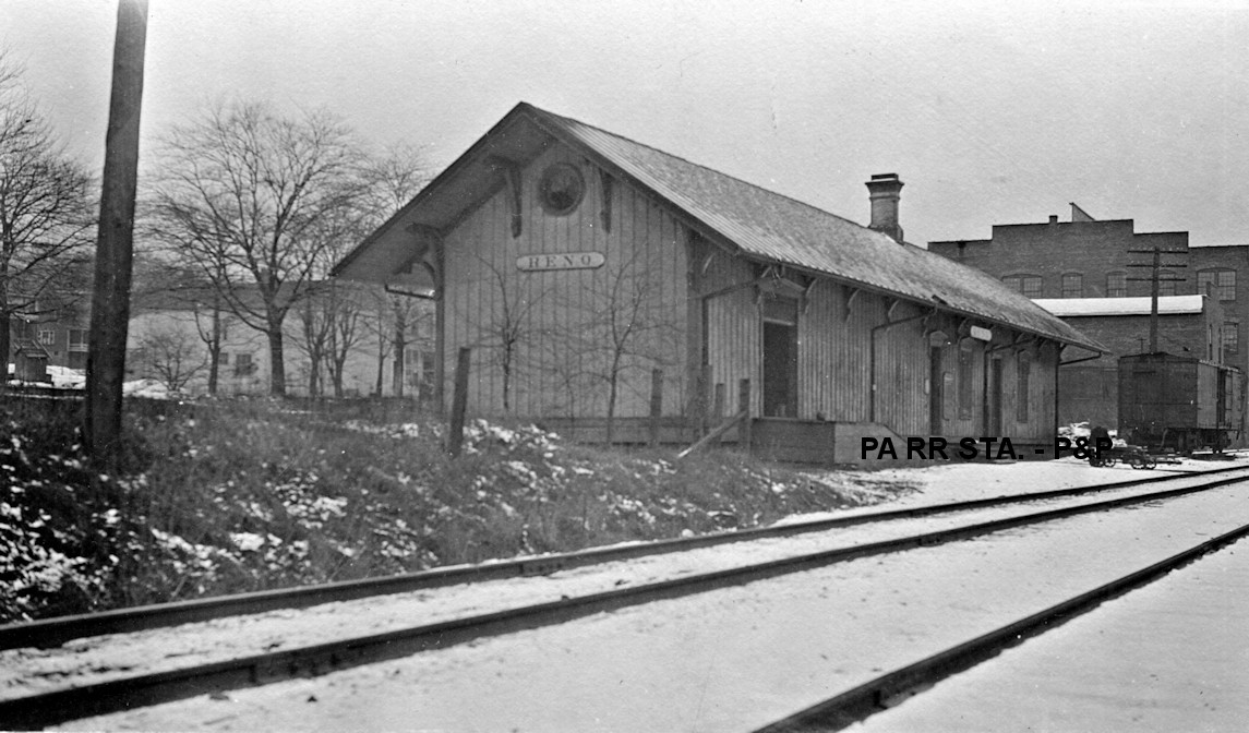
| Reno |
 |
South side of US 62 (GPS: 41.407781, -79.749906) |
C | Vacant | 1865 | In Use | Brick |
|
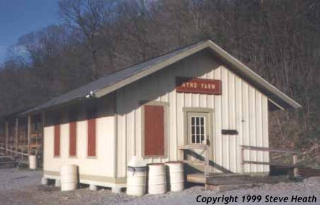
| Rynd Farm | |
Old Bankson Road off Route 8 1/2 mile north of Rouseville (GPS: 41.483618, -79.691327) |
P | Railroad | 1987 | In Use | Wood | |
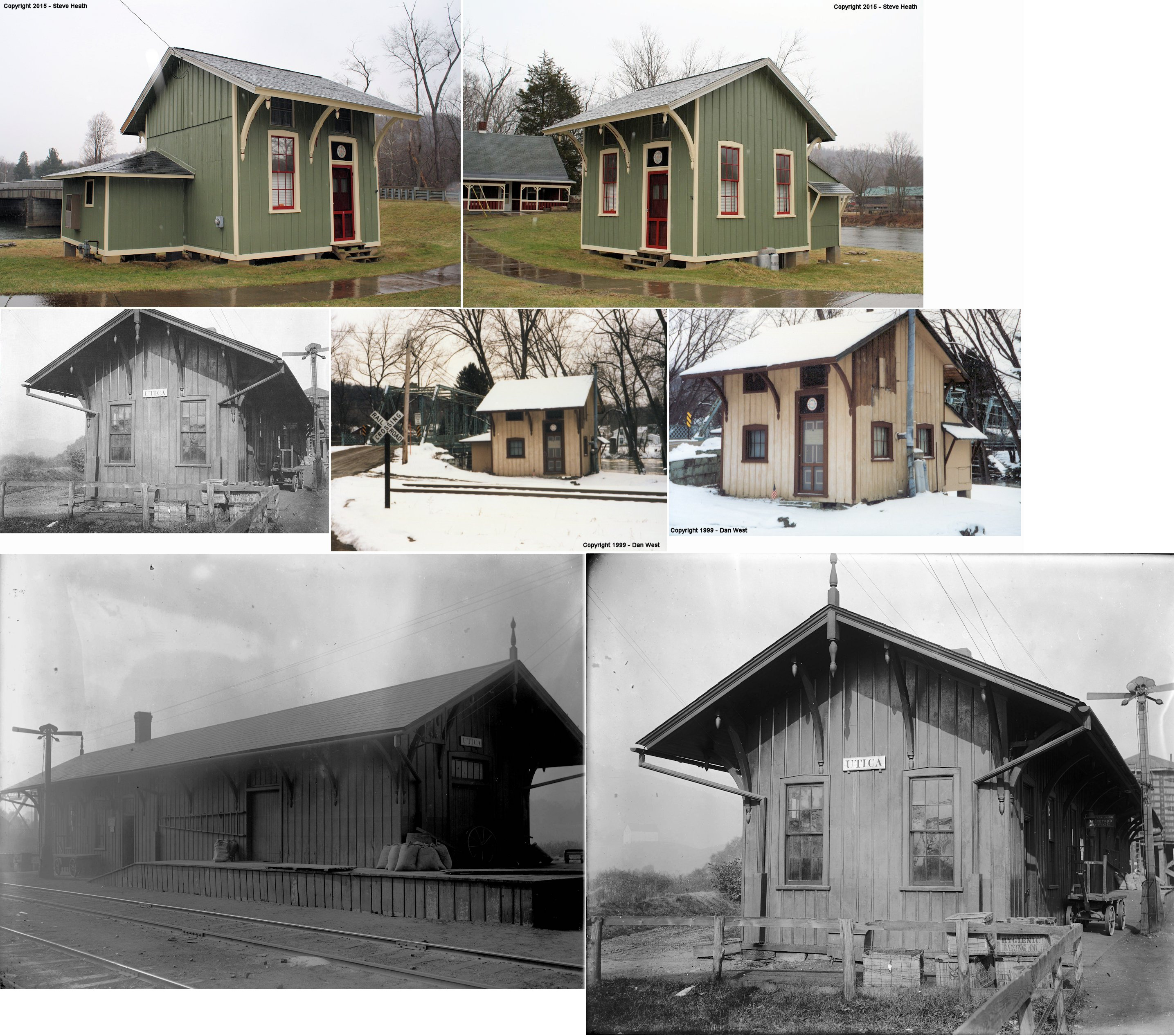
| Utica | |
East side of 3rd Street at bridge (GPS: 41.438314, -79.954954) |
P | Private | 1876 | In Use | Wood |
|
| STATIONS OF THE PAST | ||||||||
| Station Name |
Original Railroad |
Notes | ||||||
| Ajax |
 |
This station was near the corner of Ajax Road and Franklin-Belmar Drive at approximately GPS: 41.354777, -79.790998. | ||||||
| Astral | |
This station was near the end of Astral Road at approximately GPS: 41.344186, -79.773030. | ||||||
| Baum | |
This station was off Stewart Run Road on the SW side of Stewart Run (the creek) at approximately GPS: 41.472135, -79.541413. | ||||||
| Belmar |
|
This station was just south of Belmar Drive/Nettles Lane at approximately GPS: 41.332979, -79.774795. | ||||||
| Bennetts Mills | Pithole Valley RR |
This station was five-and-a-half miles from Pithole City. | ||||||
| Boughton | |
This station was between Miller Farm Station at the northern county line. | ||||||
| Brandon | |
This station was at the western end of Brandon Road around GPS: 41.315660, -79.852908. | ||||||
| Carl Station |
|
This station was just west of Mays Mills Road (T-512) at approximately GPS: 41.321271, -79.735081. According to NYC valuation records, the station was an 8'x34' carbody that was placed here in 1912. | ||||||
| Collins | |
On the branch that went to Cranberry. | ||||||
| Columbia | |
This station was somewhere between Rynd Farm and Petroleum Centre. | ||||||
| County Home | |
It appears that there was a station or shelter at the Venengo County Home west of Sugar Creek. | ||||||
|
Cranberry (Salina) |
|
This was the end of a short branch line. | ||||||
| Dixie Station | |
This station was east of French Creek Road in the vicinity of GPS: 41.407699, -79.909902. It is unlear why there was a station there. It is shown on the 1917 map, but not on the 1941 map. | ||||||
| Dotter |
 |
This station was on what is now called Carls Road (T-331) at approximately GPS: 41.209339, -79.723048. According to the Franklin News-Herald (10-17-1903), a new station was built here in 1903. | ||||||
| Eagle Rock | |
This station was near the intersection of Eagle Rock Road and Old Ferry Road around GPS: 41.452676, -79.576579. | ||||||
| East Sandy | |
This station was along what is now the Allegheny River Trail just south of where the Sandy Creek Trail crosses. It was at approximately GPS: 41.331093, -79.769089. | ||||||
| Eclipse |
|
This station was just east of Frankin at approximately GPS: 41.399988, -79.812966. A station is shown here on the 1917 map. The NYC valuation records of 1919 say that this shelter-type station measured 12'x15'. | ||||||
| Emlenton |
|
This station was on the east side of 6th Street on the south side of the tracks at GPS: 41.176727, -79.709585. The depot originally served as the station at Fullerton which was just south of Emlenton where Ritchie Run empties into the Allegheny River. Sometime prior to 1900 the station was cut into two sections and moved north to Emlenton. It was demolished in 1961 following a derailment that heavily damaged the structure. During the demolition, workers found Allegheny Valley RR documents dating to 1876 (Franklin News Herald, March 27, 1961). | ||||||
| Emlenton | |
The freight station was on the east side of 6th Street on the north side of the tracks at GPS: 41.176983, -79.709269. | ||||||
| Fernbank Station |
|
This station was just east of where the line crossed Shaw Run. There is no road to this location now, although there was an unimroved road to here on the 1941 map. The station was at approximately GPS: 41.304536, -79.706415. | ||||||
| Foster (Coal City) (Indian Bend) |
|
There appear to be no roads to the area that this station was in (although it is accessible via the river trail). It was north of the end of Titus Road around GPS: 41.327803, -79.814565. The station is known as Indian Bend on the 1923 PRR List of Stations & Sidings. | ||||||
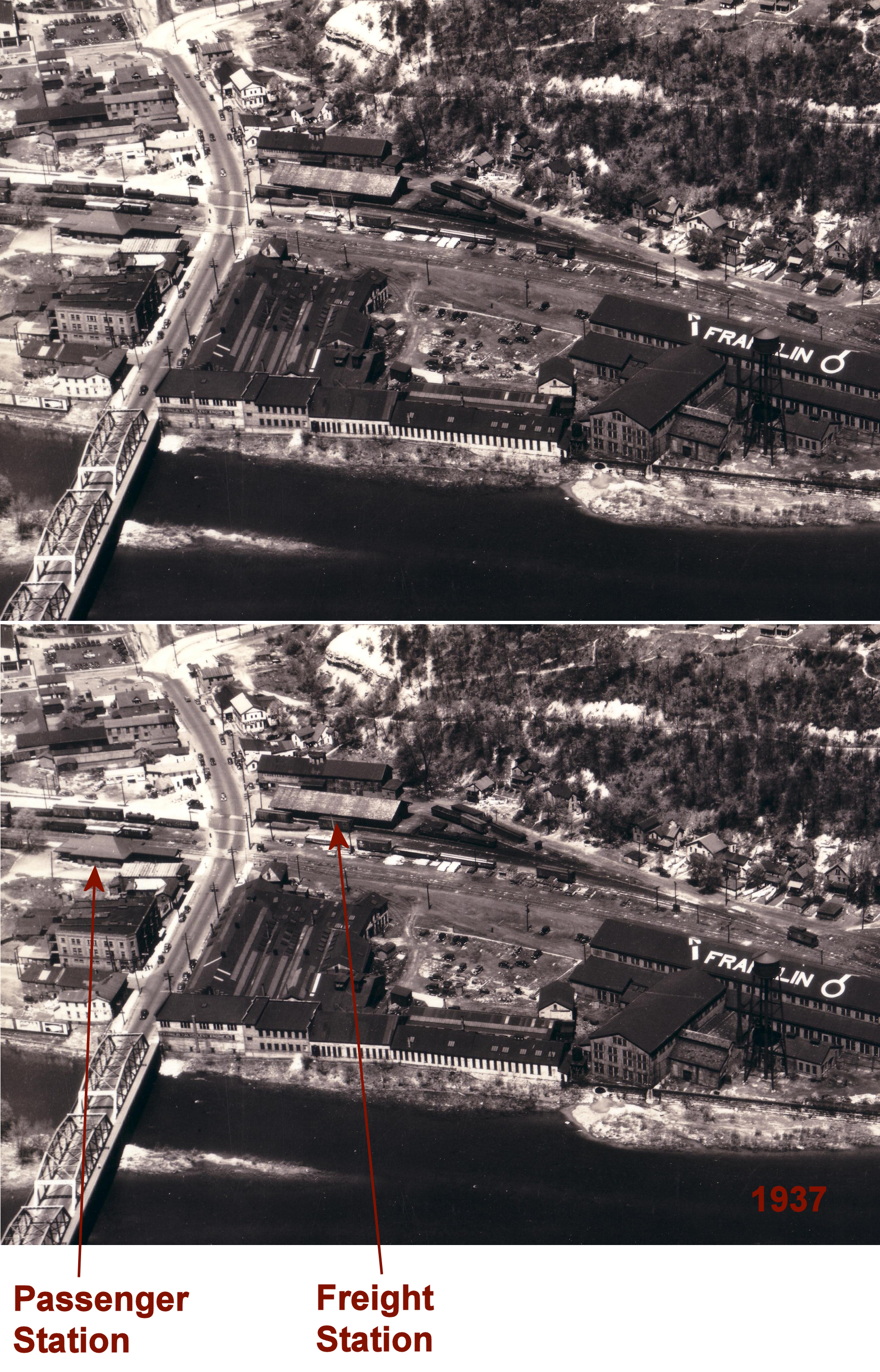
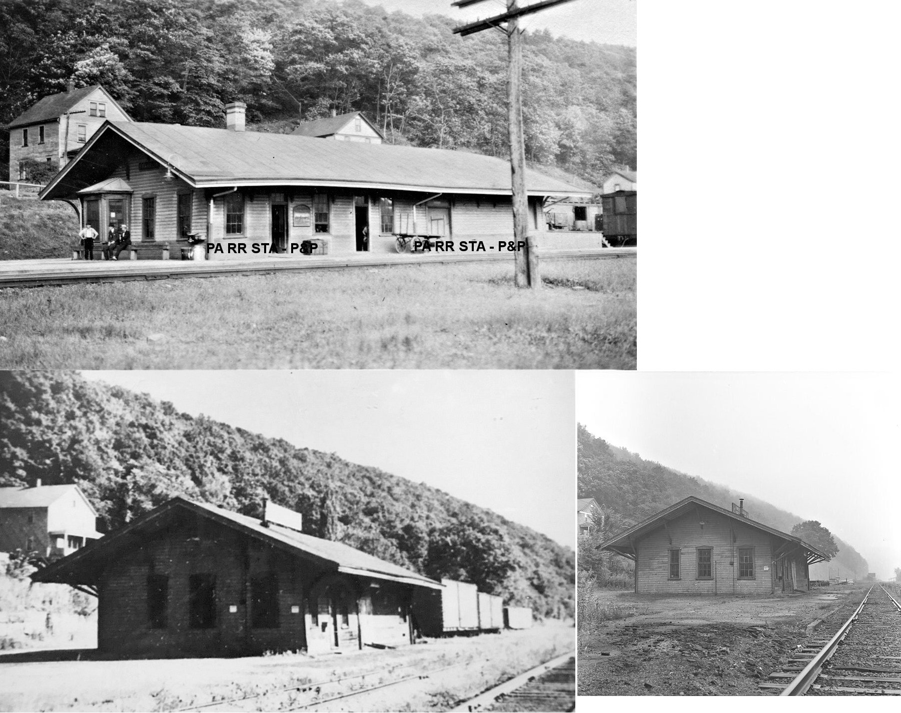
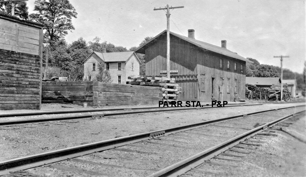
| Franklin | |
The original wood frame passenger station was on the west side of 13th Street (US 322) on the south side of the tracks at approximately GPS: 41.403284, -79.831446. | ||||||
| Franklin |
 |
In 1898 a new brick station was built at a cost of $10,000 (Warren Evening Democrat, 3-21-1898). | ||||||
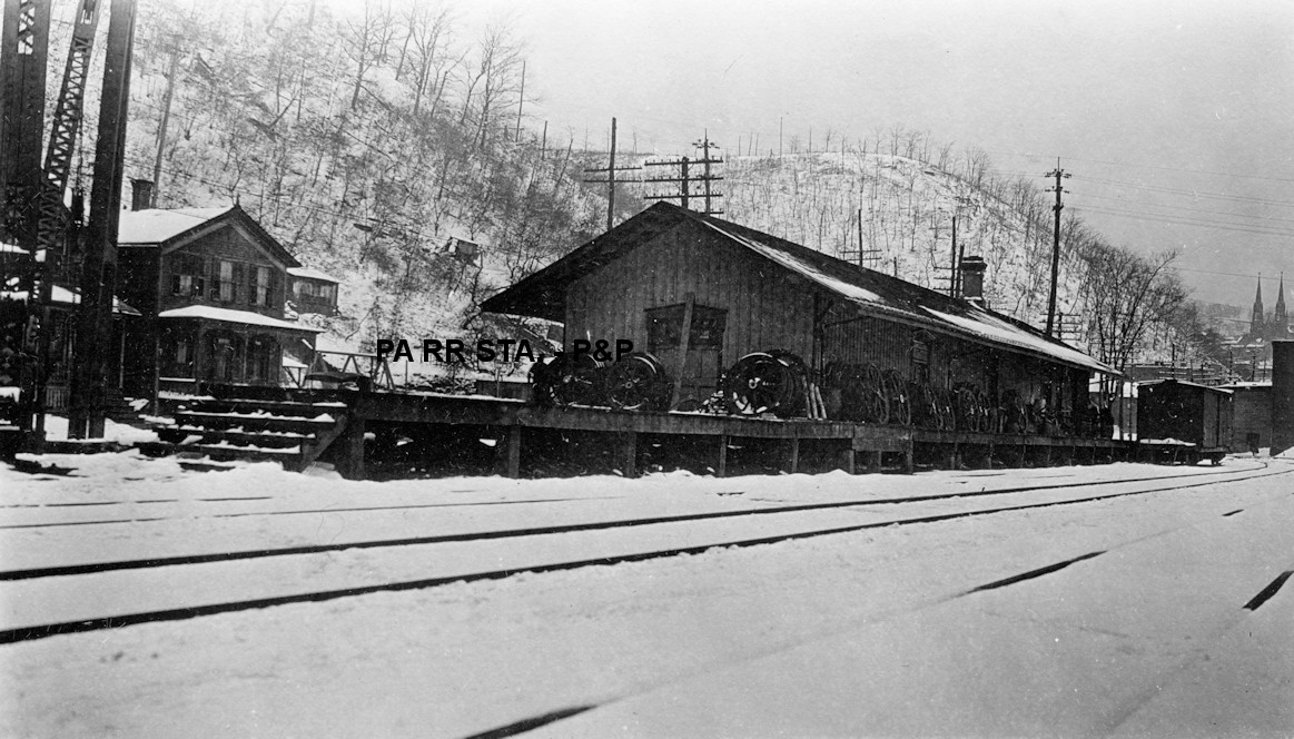
| Franklin |
|
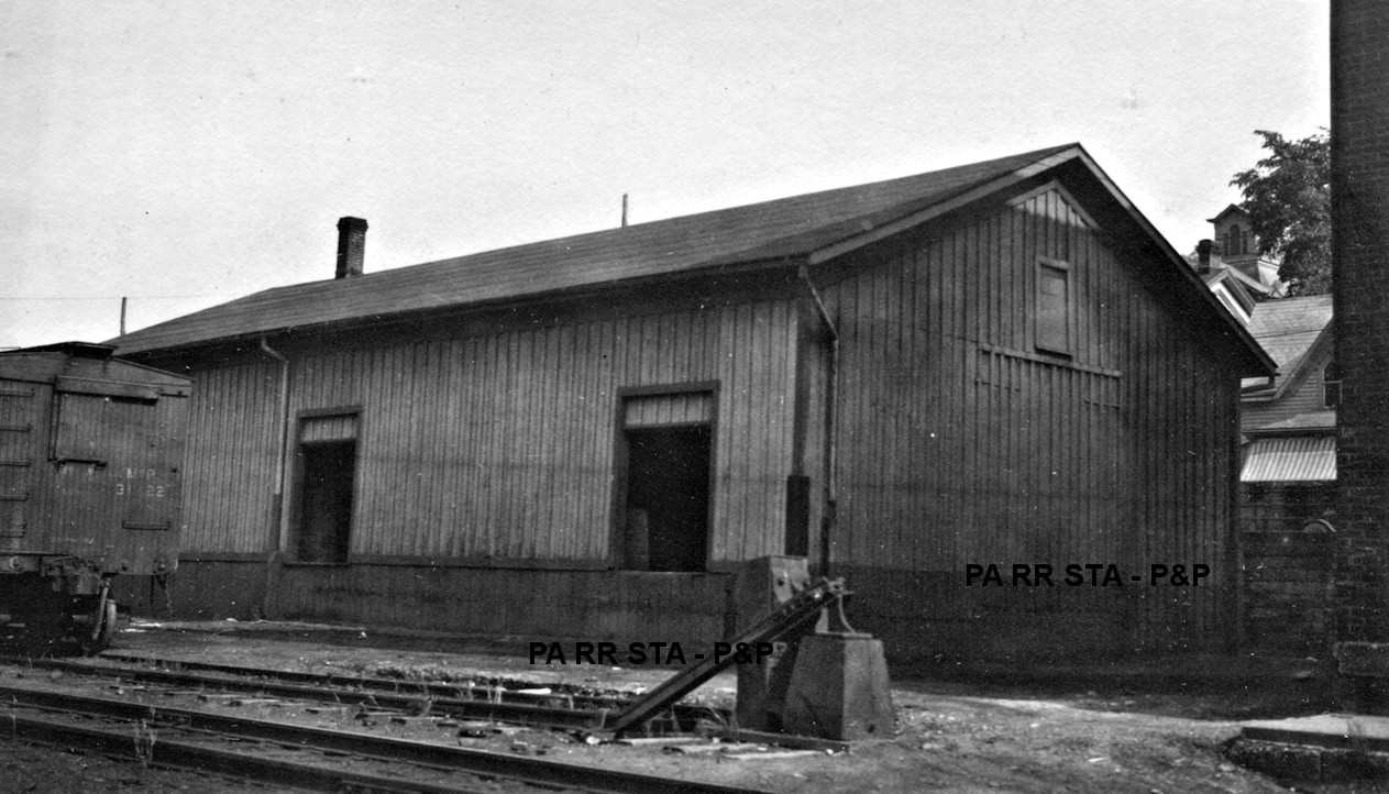
There was a large freight house on the east side of 13th Street (US 322) on the north side of the tracks at approximately GPS: 41.403598, -79.831108. The Erie valuation records from 1919 list a build date of 1899. The photo for the listing above shows the freight station. | ||||||
| Franklin | |
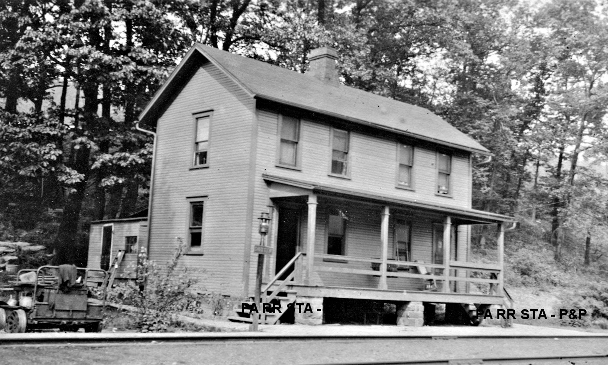
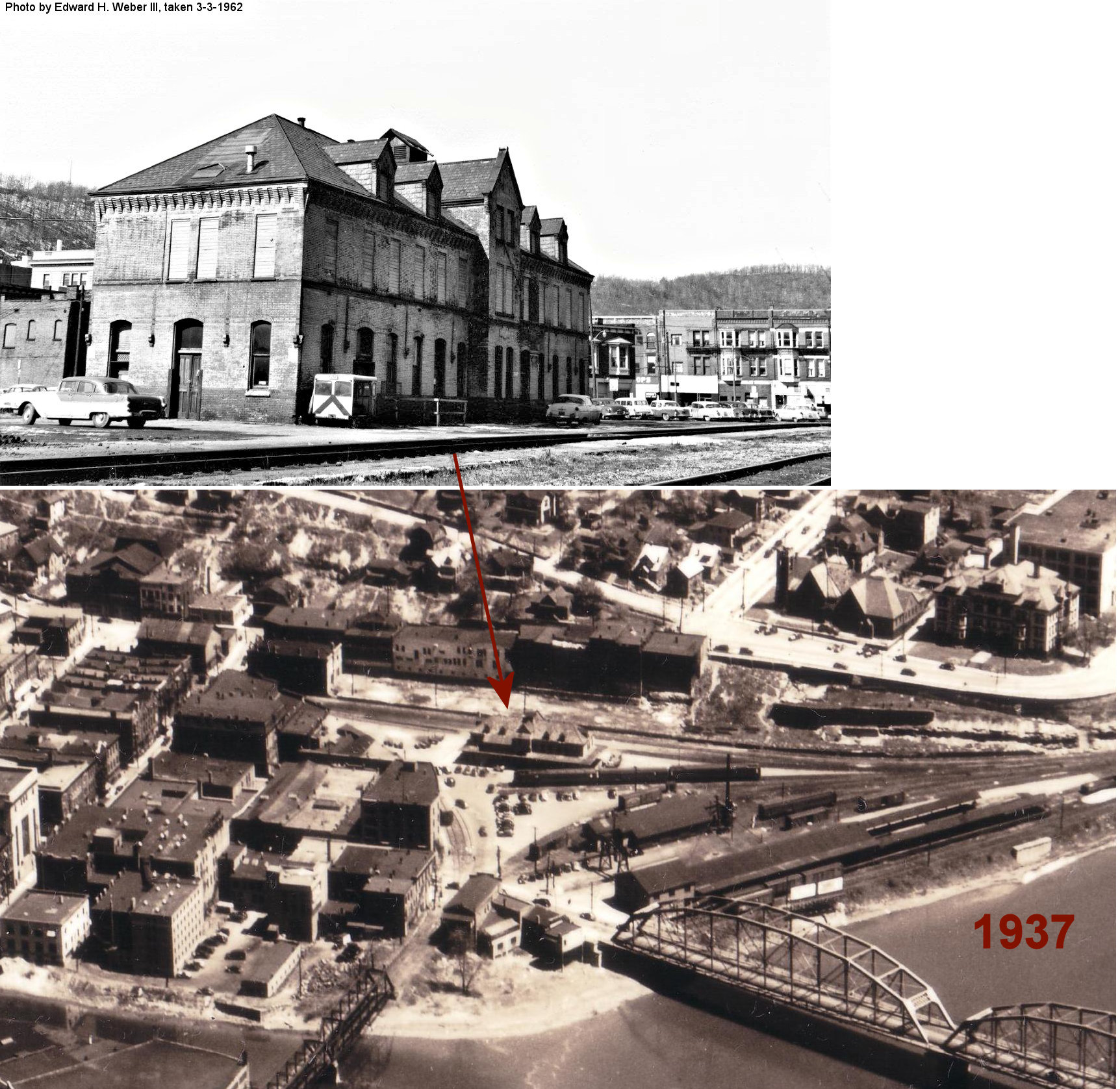
The first station here was a wood frame building on the corner of Railroad Street and 12th Street at GPS: 41.394720, -79.831086. It was torn down when the existing brick station was built sometime between 1901-1906. | ||||||
| Franklin | |
There was a large freight platform here for oil barrels. The NYC valuation records of 1919 say that this platform was built in 1900 and measured 24'x360'. Does anyone know where this was? | ||||||
| Franklin Station | |
This station was just south of the US 322 bridge south of Franklin at approximately GPS: 41.387817, -79.817562. The station was just south of the bridge here in 1922, but I am not sure that the current location of the newer US 322 bridge is the same as the old 8th Street bridge. The station was still standing as of 1950 and may still be standing in modified form (see existing station listing notes). The last passenger trains stopped here on June 9, 1953 on their runs from Corry to Oil City in the morning and back in the late afternoon. | ||||||
| Fullerton |
|
See listing for Emlenton above. This station was moved to Emlenton sometime prior to 1900. | ||||||
| Hatchville | Pithole Valley RR |
This station was six miles from Pithole City. | ||||||
| Henry's Bend | |
This station was in the vicinity of GPS: 41.468368, -79.592828. It was a converted passenger car. | ||||||
| Horse Creek | |
On the branch that went to Cranberry. | ||||||
| Indian Bend | |
See the listing for Foster above. | ||||||
| Junction | Pithole Valley RR |
This station was 6.5 miles from Pithole City. | ||||||
| Kennerdell | |
This station was on the west side of Main Street at approximately GPS: 41.269880, -79.845274. The house that still stands to the north was the station master's house. After the Kenerdell Tunnel was built this part of the line became localized with very little traffic. The line here was torn out in 1930, with the main line through the tunnel being torn out in 1988. | ||||||
| McClintock (McClintockville) |
|
This station was between Oil City and Rouseville. Not to be confused with the station listed below. This station was on the SW side of Waitz Road at approximately GPS: 41.459421, -79.691522. | ||||||
| McClintocks | |
This station was probably located at an iron furnace on the line that went to Cranberry. | ||||||
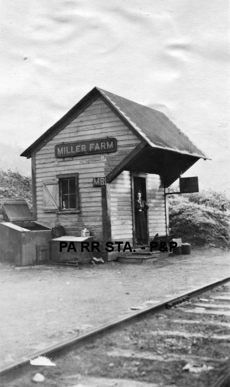
| Miller Farm Station |
 |
This station was on the east side of Miller Farm Road at approximately GPS: 41.564953, -79.656430. The station burned down on May 8, 1901. The night trackwalker and his wife lived in the station at the time. Although the trackwalker was out on rounds when the fire started, their barking dog alerted the wife to the fire and she was able to escape unharmed (New Castle Weekly Herald, 5-8-1901). | ||||||
| Miller Farm Station | |
This was likely the replacement for the station listed above. Photo is from 1919. | ||||||
| Niles | |
This station was on the south side of Georgetown Road at approximately GPS: 41.396982, -79.911422. The NYC valuation records of 1919 say that this station was built in 1906 and measured 8'x10'. | ||||||
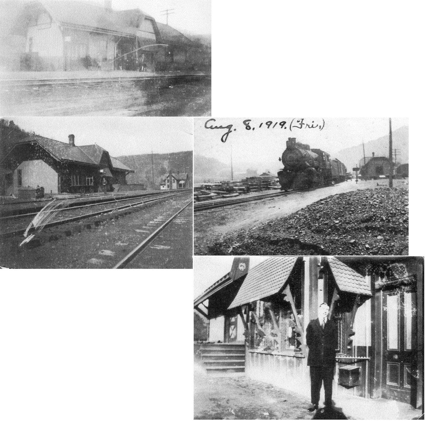
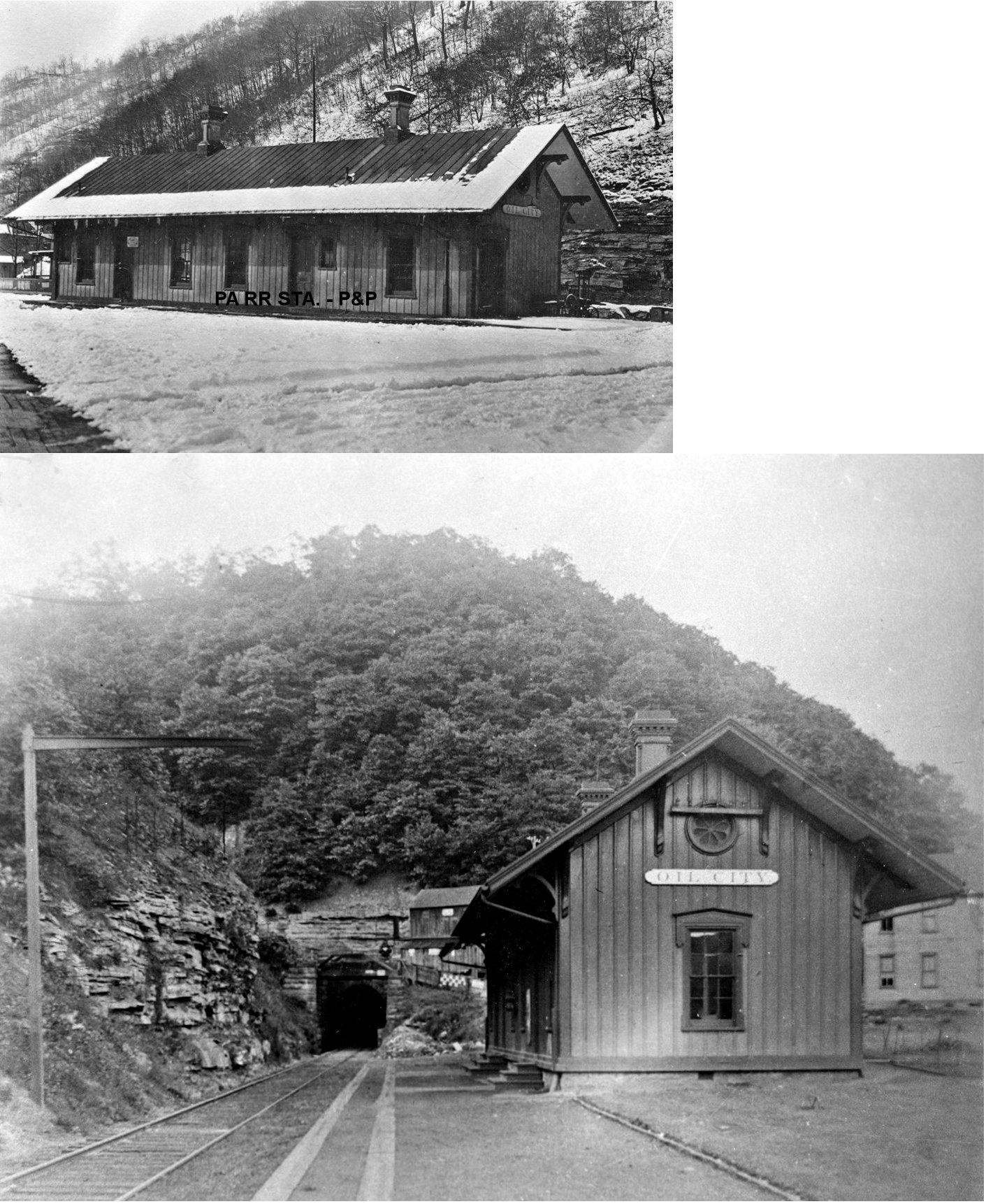
| Oil City | |
The original station was on Main Street at the north end of Bridge Street at approximately GPS: 41.432518, -79.713190. The area is occupied by the US 62 highway now. It was demolished in 1966. The Jamestown & Franklin RR built the station here in 1870-71. | ||||||
| Oil City | |
The freight station was on Main Street west of bridge street at approximately GPS: 41.432115, -79.714585. The NYC valuation records of 1919 say that this freight station was built in 1870 and measured 24'x126'. | ||||||
| Oil City |
AND  |
The original wooden Union Depot here was built in 1867 and was in service until the new brick station was built in 1883 (see below). | ||||||
| Oil City |
AND |
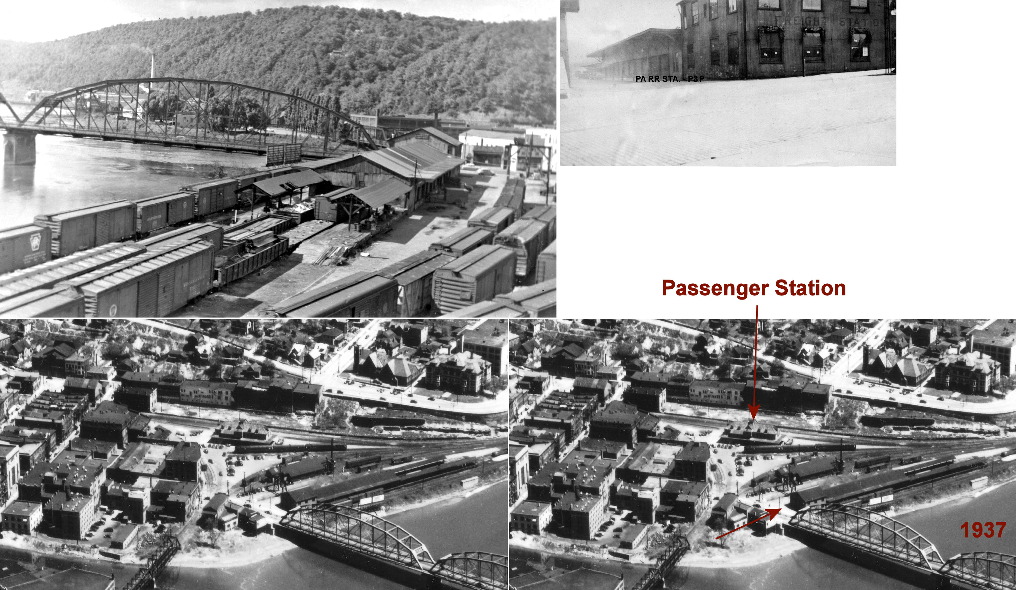
Built by the WNY&P and leased by the NYP&O, this brick union station was constructed in 1882 and opened in 1883. It was on Elm Street between the tracks at GPS: 41.432751, -79.707265. The canopy was removed from the station in 1956 by the railroad due to dry rot. The city acquired the building (and the NYP&O (Erie) freight station listed below) in early 1962. The Erie RR freight house and PRR freight house buildings were burned down by the city in a special ceremony on July 5, 1962. The brick passenger station was demolished soon after to make way for a new development project on the site (from The News-Herald, July 6, 1962). | ||||||
| Oil City |
|
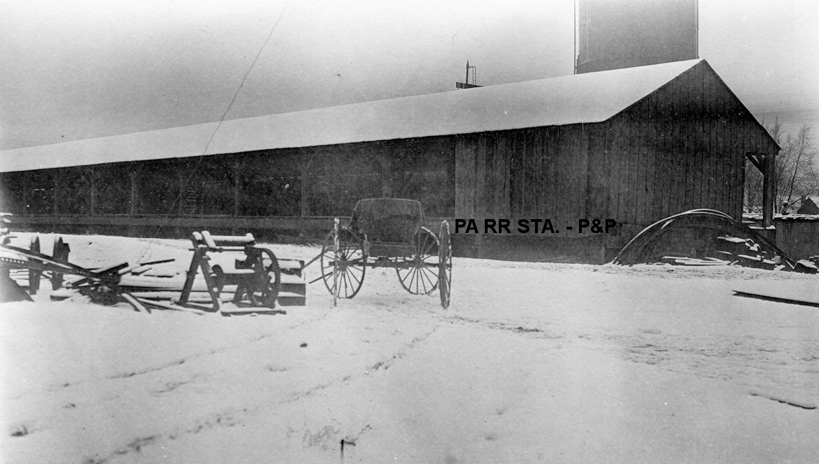
There were several different freight stations over the years along the southernmost exchange tracks around GPS: 41.432371, -79.707510. At one time the RRs had their own freight houses here and there was also a union freight house. The photo shows the Erie freight house and the large WNY&P freight station that was closer to river. That freight station was built in 1891 according to Erie RR records from 1919. | ||||||
| Oil City |
|
This is the WNY&P freight house that was next to the Erie freight station listed above. | ||||||
| Oil City (S. Oil City) |
|
This station was on the SW side of the tracks along Front Street at Walnut Street at GPS: 41.428400, -79.705810. The station is shown on the 1901 Sanborn map, but is gone by the 1906 map, however a station is listed here on the 1923 PRR List of Stations & Sidings. | ||||||
| Oleopolis | Pithole Valley RR |
Oleopolis was an early station and end point on the Pithole Valley RR. This station was 7 miles from Pithole City. | ||||||
| Oleopolis | |
This station was in the vicinity of West Riverview Road around GPS: 41.454462, -79.616241. | ||||||
| Pecan Station (Mays Mills) |
|
This station was on the north side of Old PA8 on the west side of Sandy Creek at approximately GPS: 41.335095, -79.887191. | ||||||
| Petroleum Centre | |
An early station on the Pittsburgh, Titusville & Buffalo RR here burned down on July 4, 1878 when a noon blaze claimed the depot, several offices and the central hotel in town (Conneautville Courier, 7-11-1878). | ||||||
| Petroleum Centre | |
|||||||
| Pioneer Station |
|
This station was off of Russells Corners Road at approximately GPS: 41.529038, -79.666007. Pioneer was on the north side of the creek and the station was on the south side. | ||||||
| Pithole City | Pithole Valley RR |
The Pithole Valley RR was only about 7 miles long, but had several stations. It went from Pithole City to Oleopolis. | ||||||
| Polk | |
This station was on the west side of Erie Street near McClelland Avenue. It was on the east side of the tracks at GPS: 41.366982, -79.927304. The NYC valuation records of 1919 say that this station was built in 1866 and measured 20'x56'. | ||||||
| Polk Junction | |
|||||||
| Pratherville | Pithole Valley RR |
This station was two miles from Pithole City. | ||||||
| Prentice | |
|||||||
| President Station |
|
This station was across the river from President Village at the end of Old Ferry Road at approximately GPS: 41.454965, -79.561129. | ||||||
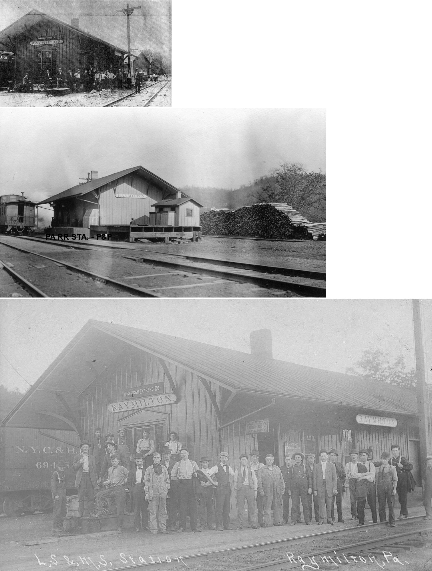
| Raymilton | |
The NYC valuation records of 1919 say that this combination station was built in 1866 and measured 20'x56'. Aside from the station, which was gone by the 1940s, the LS&MS also had an old frame roundhouse and repair shops here. | ||||||
| Reno | |
The NYC valuation records of 1919 say that this combination station was built in 1871 and measured 20'x102'. | ||||||
| River Ridge Station |
|
This station was at approximately GPS: 41.405967, -79.791019. There are no roads to this area now, but the location is on the Samuel Justus Recreation Trail. This station served River Ridge Farm. For more info on the farm see: http://riverridgefarm.org/ | ||||||
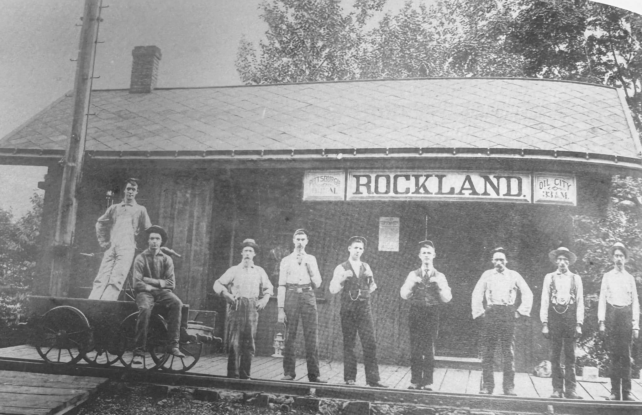
| Rockland | |
This station was on Rockland Statation Road at approximately GPS: 41.231772, -79.751602. | ||||||
| Rockmere | |
This station was east of Oil City, 3.7 miles from the Oil City station. It is listed on the 1923 PRR List of Stations & Sidings. No station is shown there on the 1941 map. | ||||||
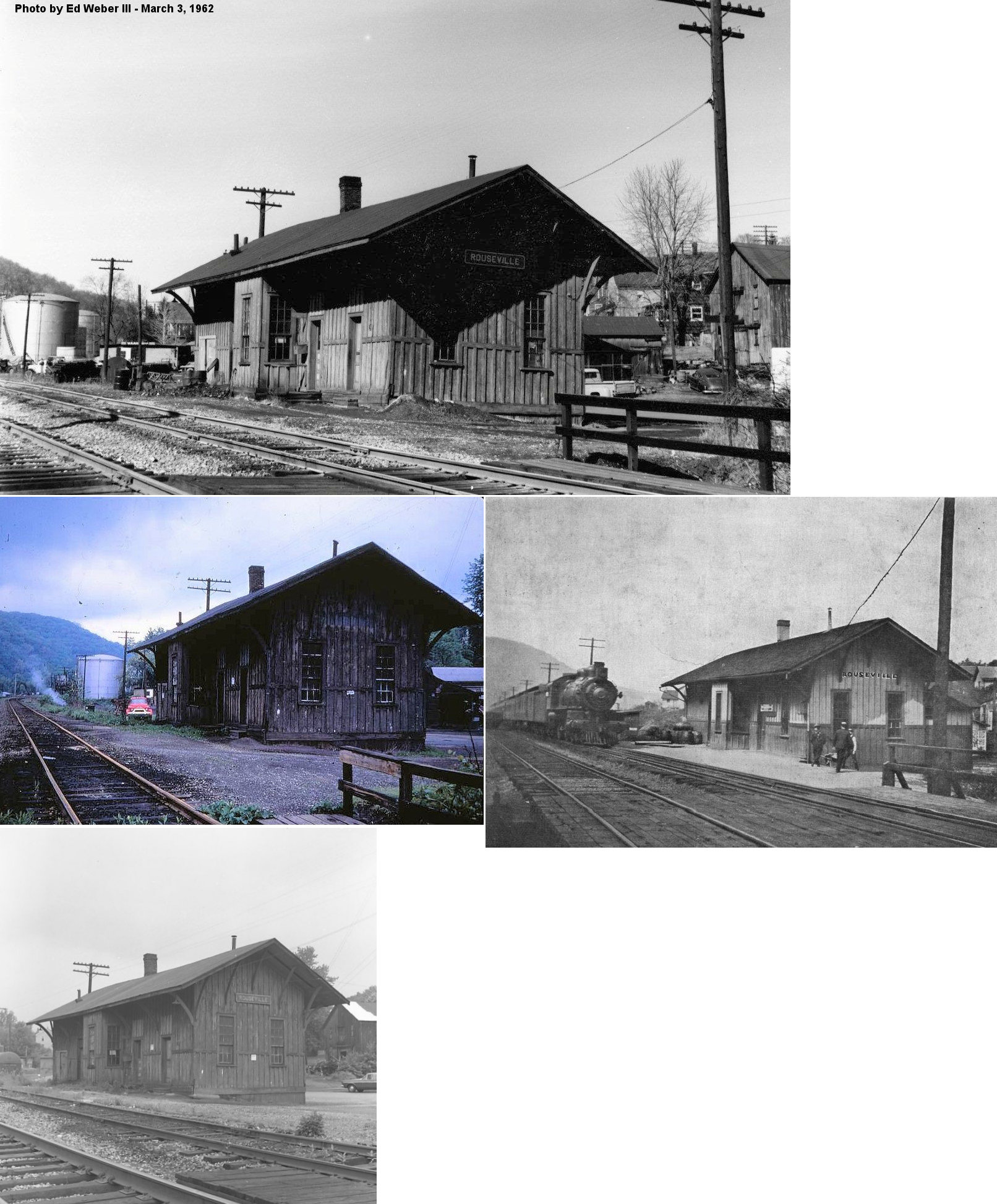
| Rouseville | |
This station was on the southern corner of Myers Avenue and Railroad Street (GPS 41.468650, -79.692220). | ||||||
| Run |
|
Listed on the 1880 LS&MS timetable. | ||||||
| Rynd Farm | |
|||||||
| Siverly | |
This station was on the SE side of Oil City. | ||||||
| SmokEy City |
|
This was a small station about four miles south of Franklin on the AVRR. There was a a collision of two trains here in 1871 that resulted in the demolition of a passenger car. Although there were nine people injured, there were no deaths (Greenville Argus, 6-19-1871). | ||||||
| St. George | |
This station was near the intersection of St. George Road and Upper St. George Road at approximately GPS: 41.249019, -79.791390. | ||||||
| Sugar Creek | |
This combination station/agent dwelling was along Sugar Creek Drive at approximately GPS: 41.420577, -79.878526. It was built in 1875-76 according to Erie RR valuation records. According to the Franklin News Herald (6-20-1933) the station was razed on June 20, 1933 and the lumber was salvaged by a man who planned to build a house with it in Maple Dale. | ||||||
| Summit |
|
|||||||
| Takitezy | |
This station was near the end of Takitezy Drive at approximately GPS: 41.412884, -79.923584. The Erie valuation records from 1919 list a build date of 1913 for a waiting shed here. | ||||||
| Van |
|
This station was on the NE side of U.S. 322. According to NYC valuation records, it was built in 1909. | ||||||
|
Venango (Cochran) |
|
Not to be confused with the Venango Erie station in Crawford County, this station was near where Lower Two Mile Run emptied into the Allegheny River at approximately GPS: 41.373334, -79.801126. This station was originally called "Cochran" until 1906 when the railroad changed the name to "Venango." | ||||||
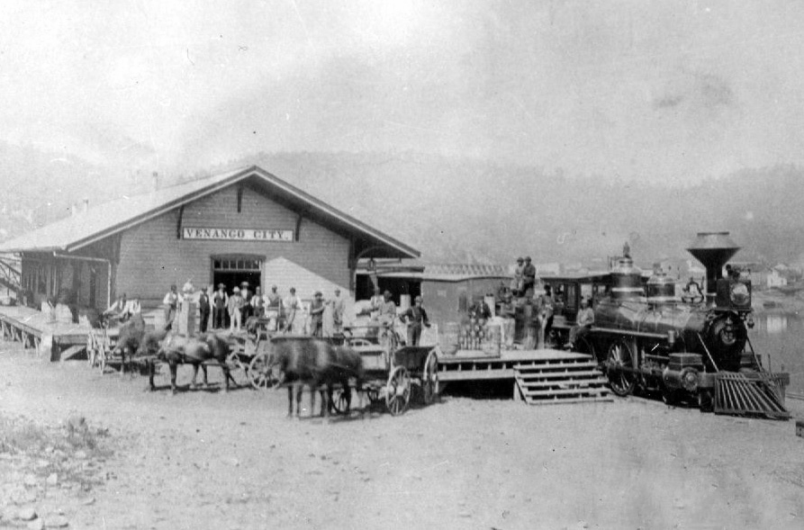
| Venango City |
|
Before it was unified into Oil City, Venango City had an Allegheny Valley RR station that was built there in 1869. | ||||||
| Walnut Bend | |
This station was at the end of West Walnut Bend Road at approximately GPS: 41.466432, -79.649138. | ||||||
| Wood Hill | |
This station was between Dotter and Rockland four miles north of Emplenton between the two tunnels. It is shown on the 1908 PRR timetable. | ||||||
| Woods Mills | Pithole Valley RR |
This station was four miles from Pithole City. | ||||||
| Wright Station |
|
There are is no longer a road to this area, although the 1941 map shows an unimproved road to this location. That road ran south from Whippoorwill Road and crossed the East Sandy Creek. The station was at approximately GPS: 41.299757, -79.680592 near where this old road crossed the creek. That road continued south and then east to Hepler Road. Part of this road may be what is today known as Seneca Hardwood Road. | ||||||
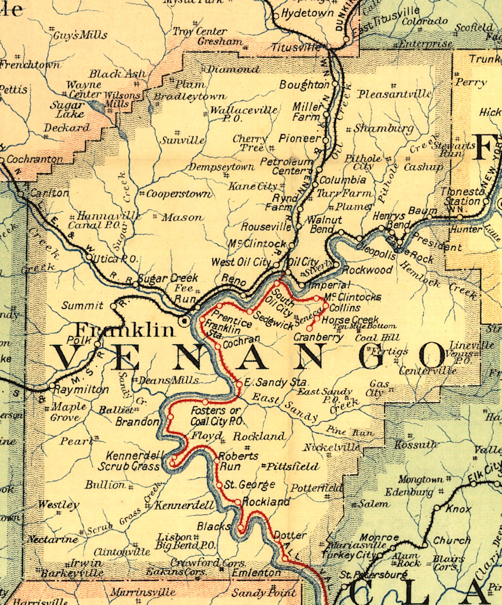
| 1895 VENANGO COUNTY RAILROAD MAP | ||||||||
 |
||||||||
| Notes About Existing
Stations... Franklin (LS&MS Freight) - Fire damaged a large section of the building in 2001. The NYC valuation records of 1919 say that this station was built in 1867 and measured 30'x174'. Franklin Station (PRR) - Now houses Country Pedalers Bicycle Rental. As shown on Sanborn maps, the original station here was a combination station located to the south of the old 8th Street Bridge. It is now out of position in relation to the Rt. 322 bridge because the old bridge was torn down and the new bridge was repositioned about 45 degrees to the south. That put the old station on the north side of the bridge instead of the south. So, this building may be the remaining part of the combination station. Can anyone confirm? Oil City (OC&T) - Originally a gas station, now used by the OC&T as a railroad station. Reno (Erie) - When it became non-agency it lost its distinctive depot architecture was leased to the adjoining Wolf's Head refinery where it served as "Building 10." Today the refinery is closed but the station building remains. The Erie valuation records of 1919 say that this combination station was built in 1865. Utica (A&GW) - This may be part of the original station. It looks just like the old AG&W station, but not as long. |
||||||||