|
|
||||||||
| EXISTING STATIONS | ||||||||
|---|---|---|---|---|---|---|---|---|
| Station Name |
Original Railroad |
Current Location |
Type | Current Use |
Date Built |
Track Status |
Building Material |
More Info |
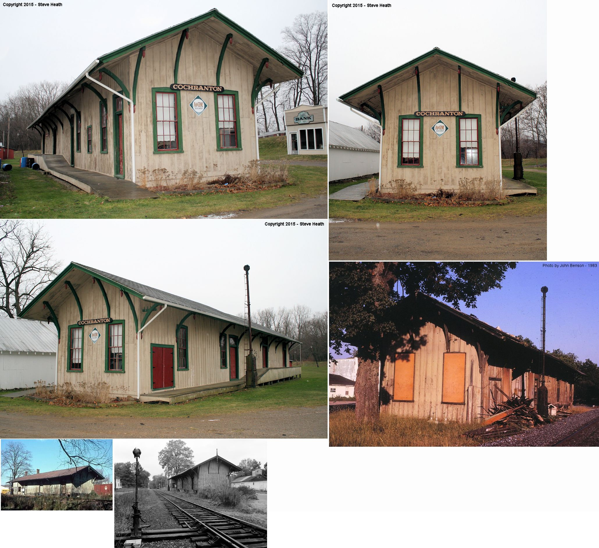
| Cochranton |  |
Fairgrounds near the corner of River Street and Walnut Street (GPS: 41.521339, -80.052198) |
C | Display | 1876 | None | Wood |
|
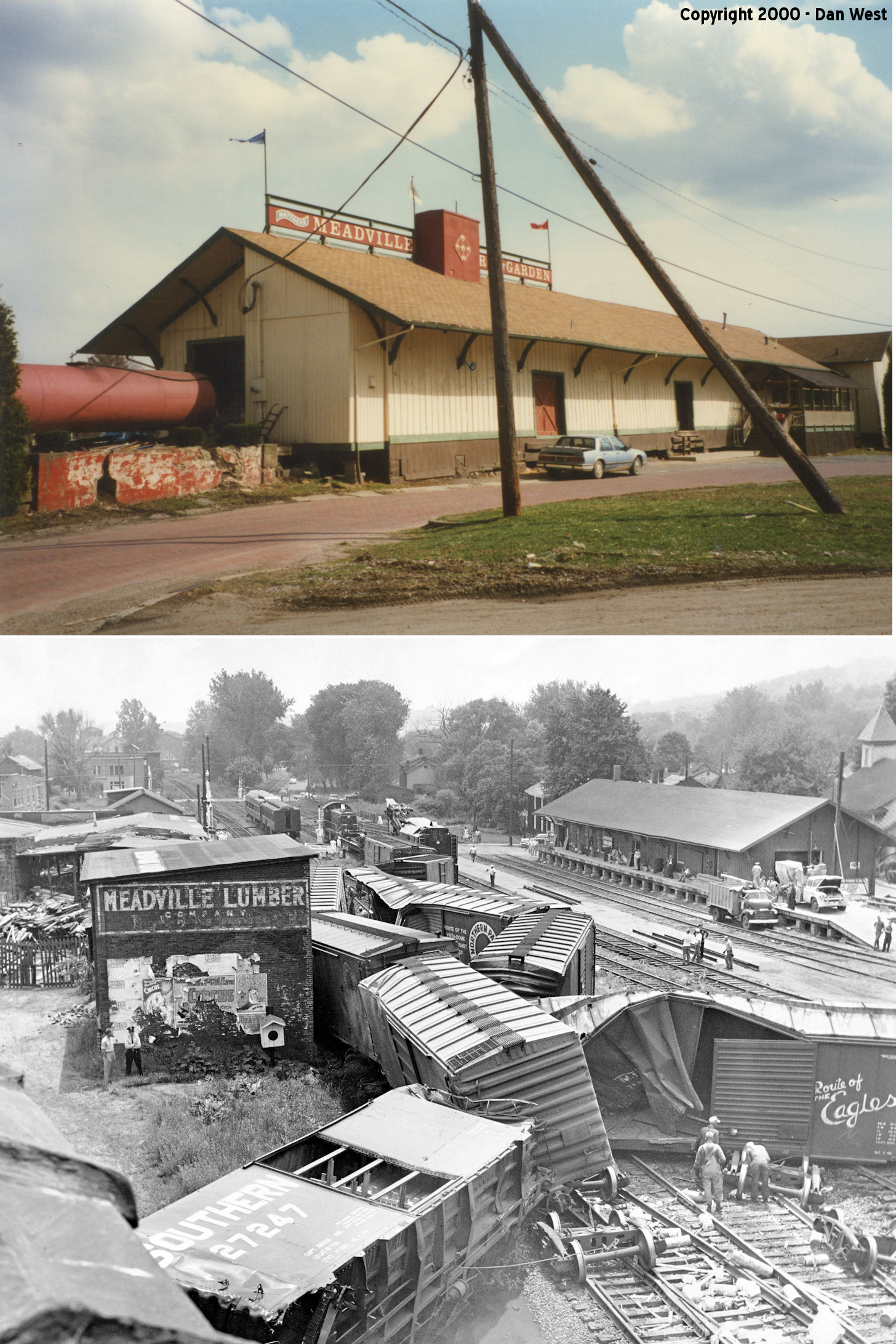
| Meadville |
 |
136 Mead Avenue (GPS: 41.636858, -80.158257) |
C | Business | 1881 | Gone | Wood |
|
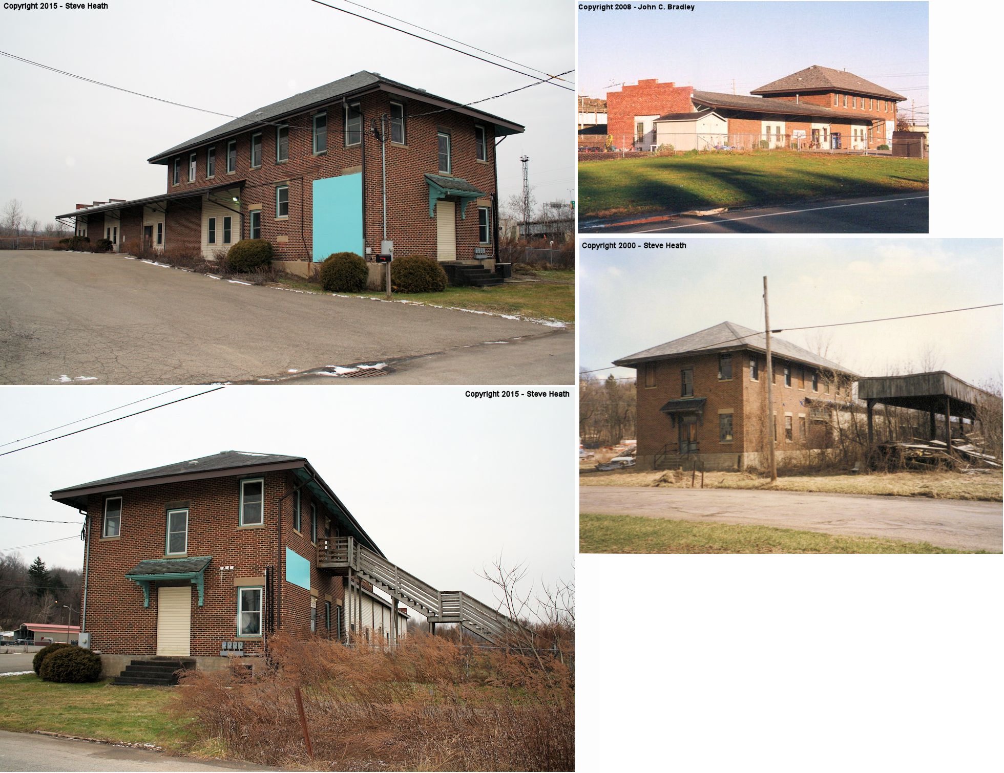
| Meadville |  |
19019 Cochranton Road (US 322 and Clark Road) (GPS: 41.625577, -80.155534) |
F | Storage | 1922 | In Use | Brick | |
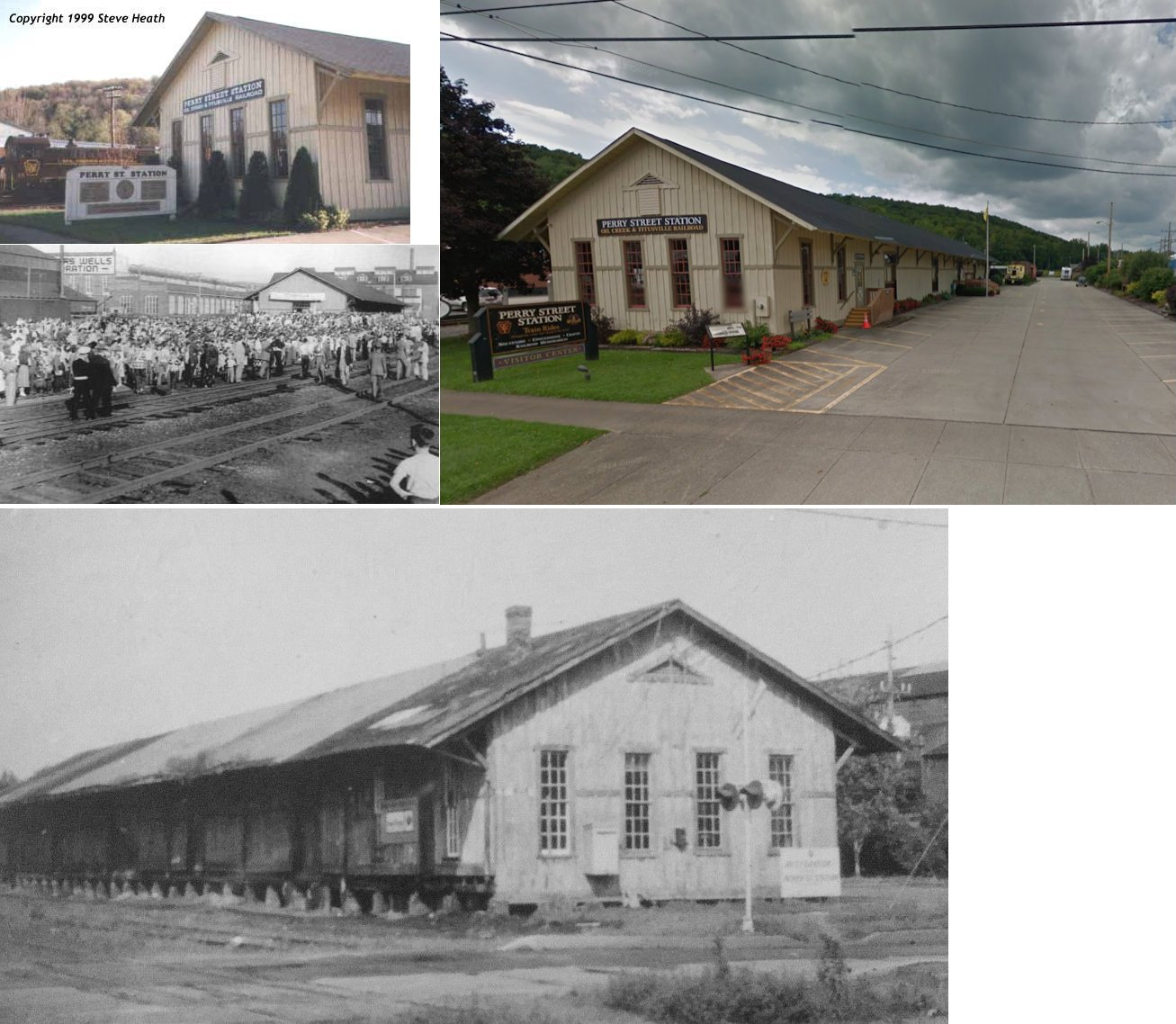
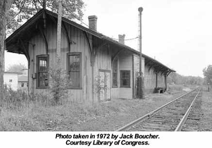
| Titusville |  |
407 Perry Street (GPS: 41.624056,-79.677551) |
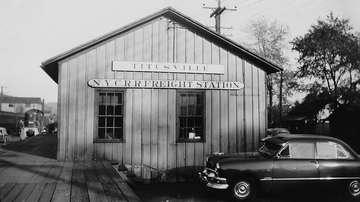
F | Museum | 1893 | In Use | Wood | |
| STATIONS OF THE PAST | ||||||||
| Station Name |
Original Railroad |
Notes | ||||||
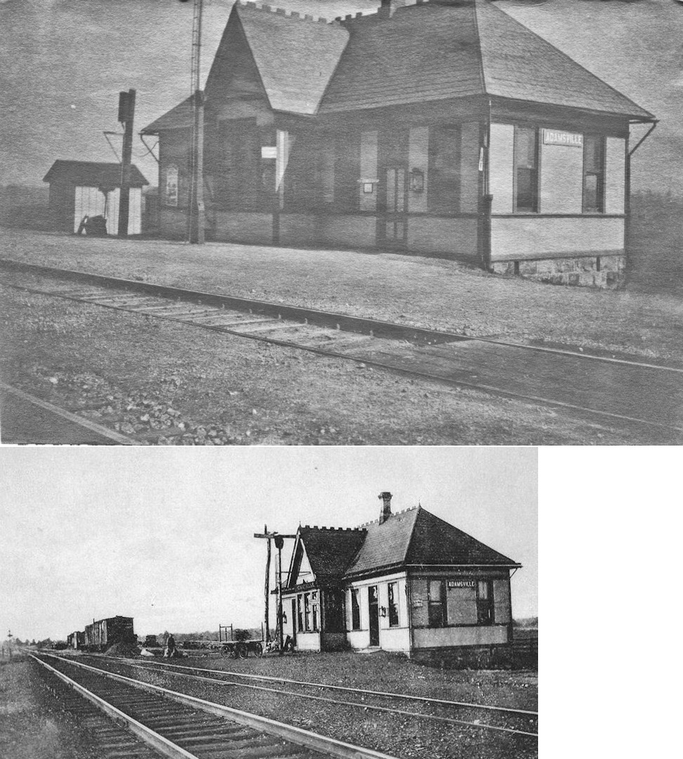
| Adamsville |  |
This station was on the north side of Adamsville Road on the west side of the tracks at approximately GPS: 41.512142, -80.365999. The depot was built here in 1891 when the line was known as the PS&LE (Meadville Evening Republican, 6-30-1891). B&LE ICC valuation records list the build date as 1888. | ||||||
| Atlantic (Adamsville Station) |
|
This station was on the south side of Atlantic Road on the west side of the tracks at approximately GPS: 41.504719, -80.340780. The 1941 map shows the station on the north side of the road at the west end of Depot Street at GPS: 41.505930, -80.340549. The station was originally called "Adamsville Station," but at some point the name was changed in honor of the railroad. | ||||||
| Buchanan Junction | |
This station was the first south of Meadville. It was west of what is now U.S. 322 at GPS: 41.597384,-80.147324 where the two lines junction. There are no roads to this location today. It was also known as Buchanan Station. | ||||||
| Cambridge
Springs (Cambridgeboro) |
 |
This station, was at 302 Venango Avenue (US 6) at the end of Spring Street on the south side of the tracks at GPS: 41.803352, -80.059792. The trolley station shown in the photo is still standing (as of 2014). The OCT uses a waiting room in the fire station for their trains. The station was built in 1891, remodeled in 1914, and was torn down in 1964. The current fire station now sits on the old Erie station property and is now used as a waiting room for the OC&T RR. The land for the fire station was donated by the Erie RR in 1957 with the stipulation that the fire station contain a waiting room for Erie passengers (passenger service had dwindled by then so a full RR station was not needed). By the time the fire station was built however passenger service had virtually ended so it is not clear if the fire station was used for a brief time as a waiting room for the RR. | ||||||
| Cambridge Springs | |
There was a freight station on Railroad Street at the end of Carringer Street on the north side of the tracks at GPS: 41.803562, -80.060721. The station was gone by 1927 and replaced with the one listed below. | ||||||
| Cambridge Springs | |
A new, larger freight station was built on Bolard Avenue at GPS: 41.80296,-80.065696. It was torn down 1981. In its later years it had been relegated to use by the local track gang as a tool and material storage building. | ||||||
| Canadohta Lake (Lakeville Station) |
|
This line was originally the Union & Titusville RR (a.k.a. "The Pigtail Railroad"). The 1876 map shows the RR continuing north from this location into Erie Co., whereas the 1897 map shows the line ending here on the west side of the lake. The 1912 map shows a station here. | ||||||
| Center Road (Summit Station) |
 |
See listing for Summit Station below. | ||||||
| Centerville | |
According to the 1876 map, there were two stations here originally. One was on the OC&AR (Oil Creek & Allegheny River) mainline on the east side of town and the other was on the OC&AR Union Branch on the west side of town. Both stations were on the north side of what is now Centerville Road on their respective lines. The station on the Union Branch was gone by 1897. The other station was demolished in a May 28, 1951 derailment (Franklin News Herald, 5-28-1951). According to an article in the Titusville Herald (3-25-1960), when Titusville outgrew its depot, it was moved on flatcars to Centerville. In the article that is presented as an old story, so it may or may not be true. | ||||||
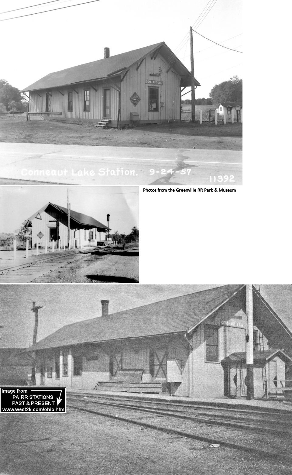
| Conneaut Lake (Evansburg) |
|
The station, built in 1881, was on the south side of US 322/PA18 at GPS: 41.602903, -80.297605. It was built by the Meadville Railway prior to the line becoming part of the B&LE. It was torn down sometime after 1977. | ||||||
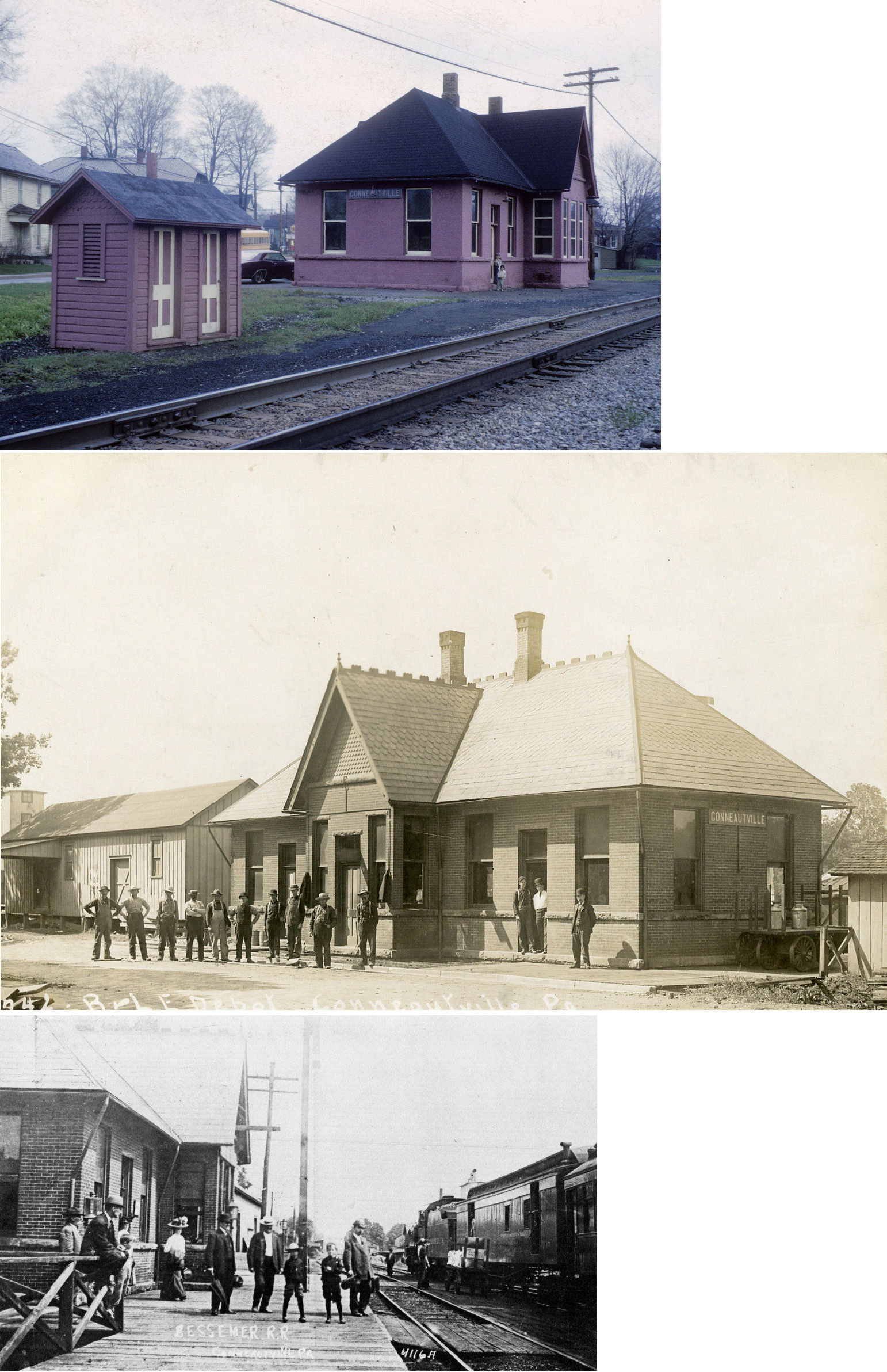
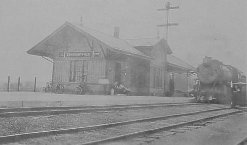
| Conneautville | |
This station, was at the corner of Main Street and Chestnut Street at GPS: 41.759506, -80.371451. The depot was built here in 1891 when the line was known as the PS&LE (Meadville Evening Republican, 6-30-1891). The freight house was next to the passenger station on the SE side. | ||||||
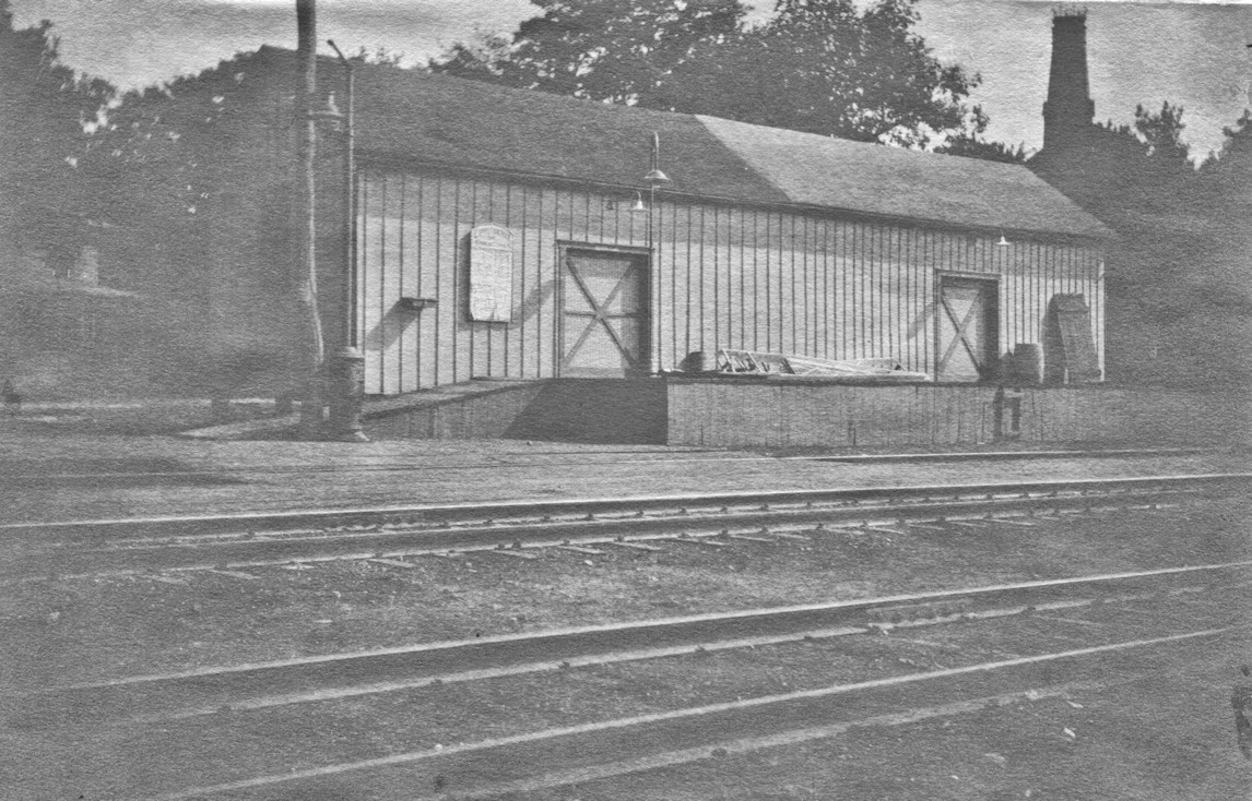
| Conneautville | |
This freight station was built in 1899 and then extended in 1901. | ||||||
| ConneautvillE Station | |
This station was on the north side of PA198 on the east side of the tracks at approximately GPS: 41.760714, -80.402303. A station is shown here on the 1876 map and thereafter. | ||||||
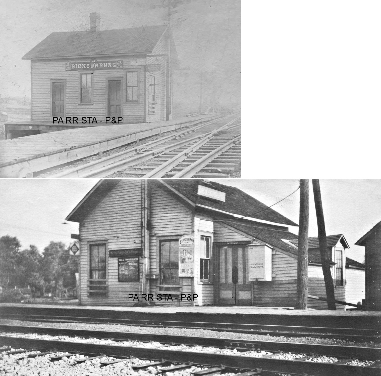
| Dicksonburg | |
This station was on the south side of Dicksonburg Road on the east side of the tracks at approximately GPS: 41.704907, -80.351527. The building pre-dates the railroad as its original purpose was as a schoolhouse. After that, it served as a residence for Charles Brewer before being purchased by the railroad in 1891 and being moved to trackside. The station burned down on July 4, 1916 (Conneautville Courier, 7-5-1916). | ||||||
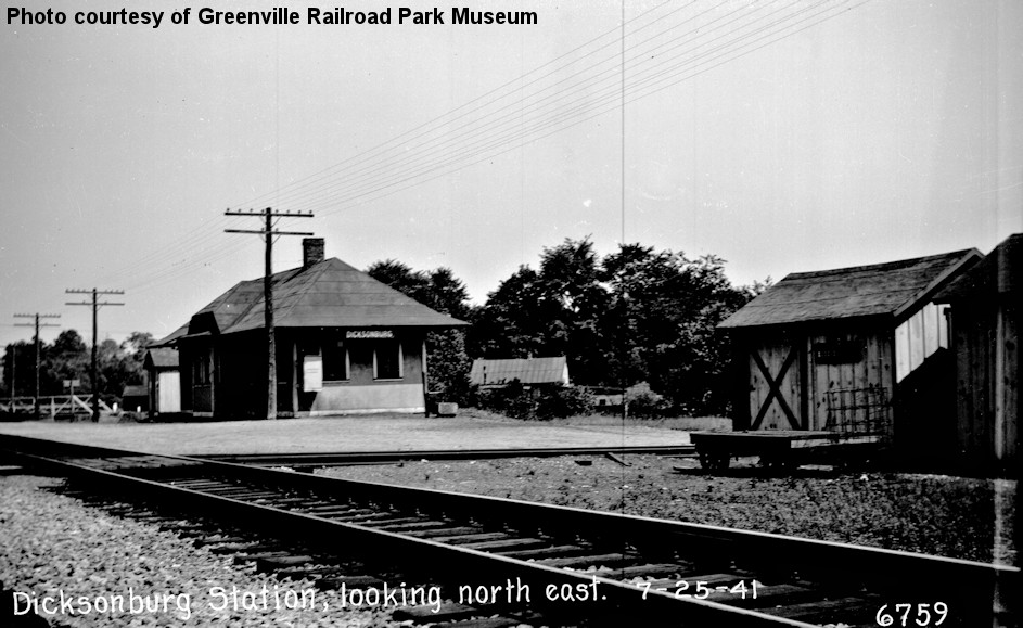
| Dicksonburg | |
This was the second-generation station here, likely built in 1916 as a replacement for the station listed above. | ||||||
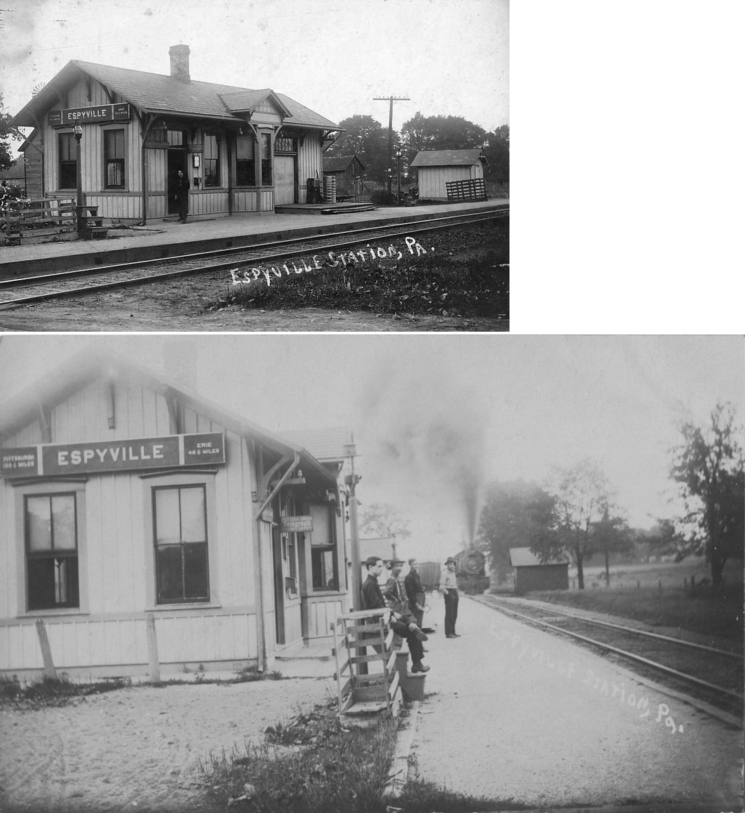
| Espyville | |
The first station here burned down in 1877 (Conneautville Courier, 7-19-1877). | ||||||
| Espyville | |
The second station here burned down in 1889. | ||||||
| Espyville | |
The third station, built in 1890, was on the north side of PA285 on the west side of the tracks at GPS: 41.605082, -80.465576. The station measured 16' x 41' (Conneautville Courier, 7-17-1890). | ||||||
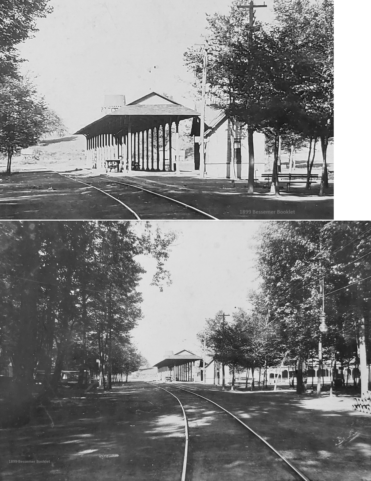
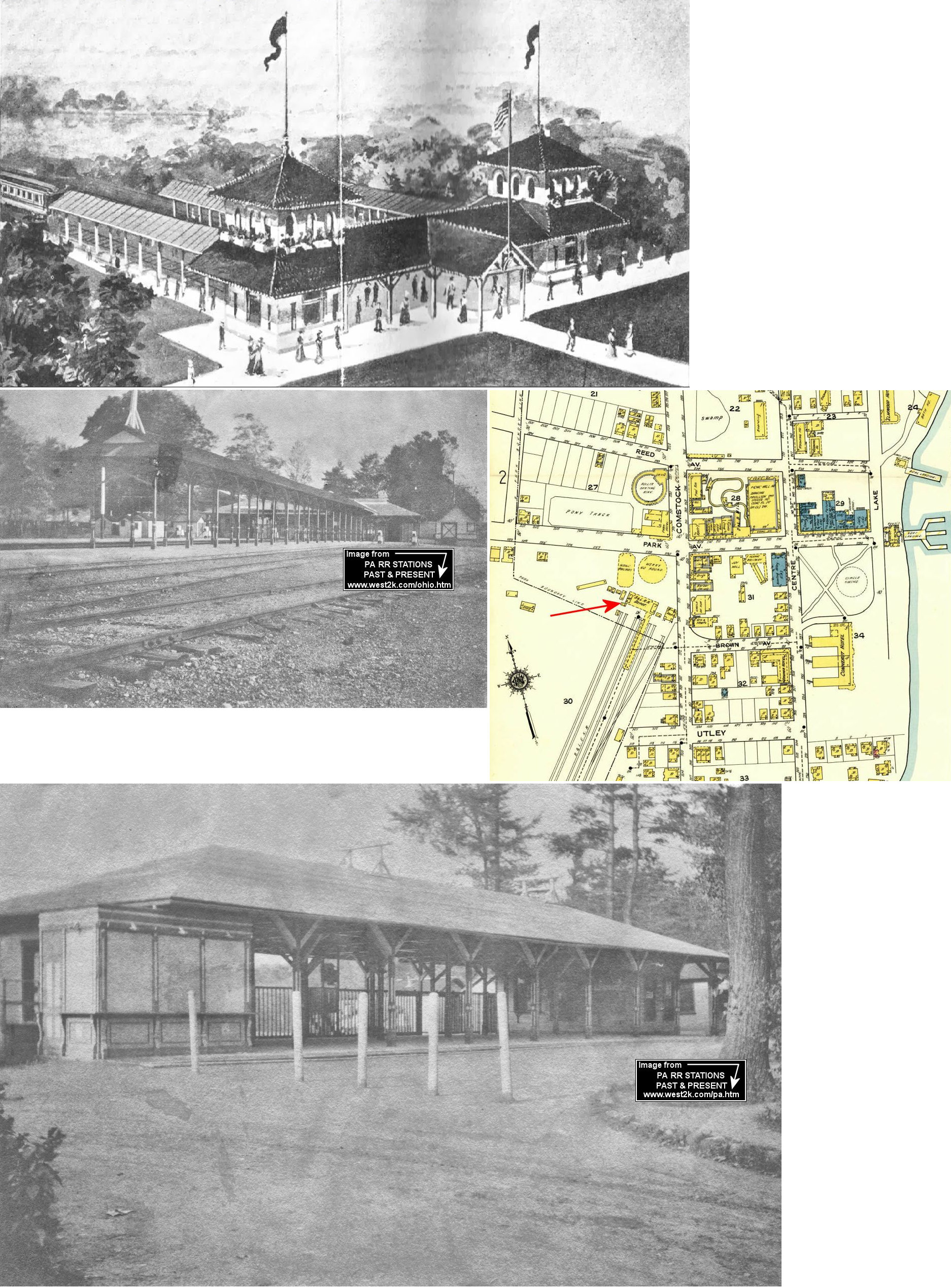
| Exposition Park Station | |
The first station at the park was built in 1892 near the northern side of the park. It was likely near the intersection of Comstock Street and Park Avenue. | ||||||
| Exposition Park Station | |
This second generation station, built in 1903, was near the corner of Comstock Street and Park Avenue just south of the merry-go-round that was on the corner there. The station was at GPS: 41.634420, -80.316116. | ||||||
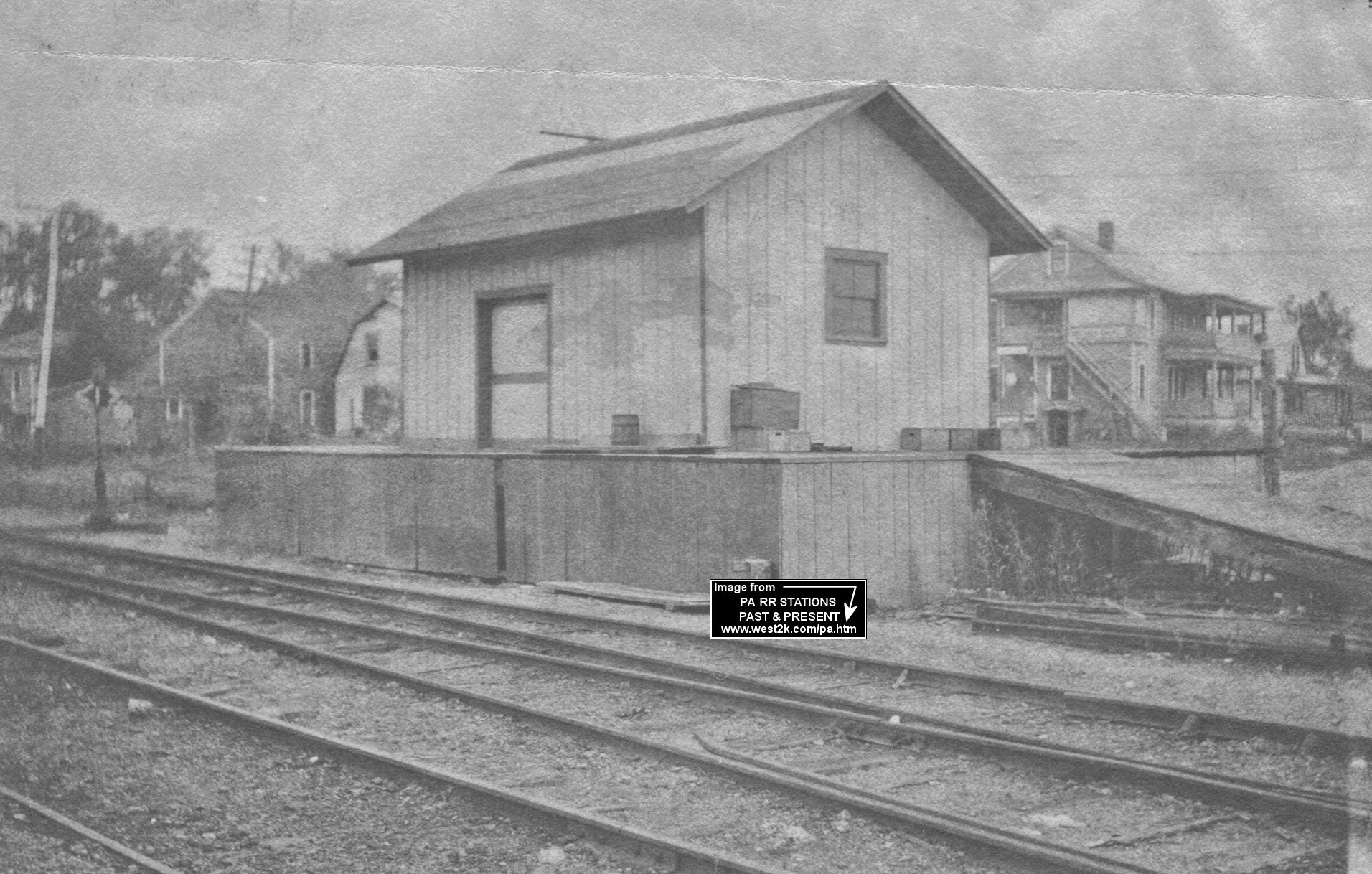
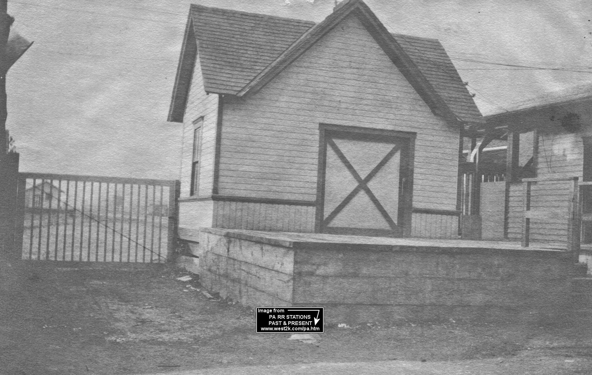
| Exposition Park | |
This freight station was built in 1906. | ||||||
| Exposition Park | |
Wells Fargo express office, also built in 1906. You can see the freight station in the background of the photo. | ||||||
| Fieldmore |
 |
There was station here that served the Fieldmore Springs Resort near Titusville. | ||||||
| Gherton |
|
This station was between Shermansville and Meadville Junction. | ||||||
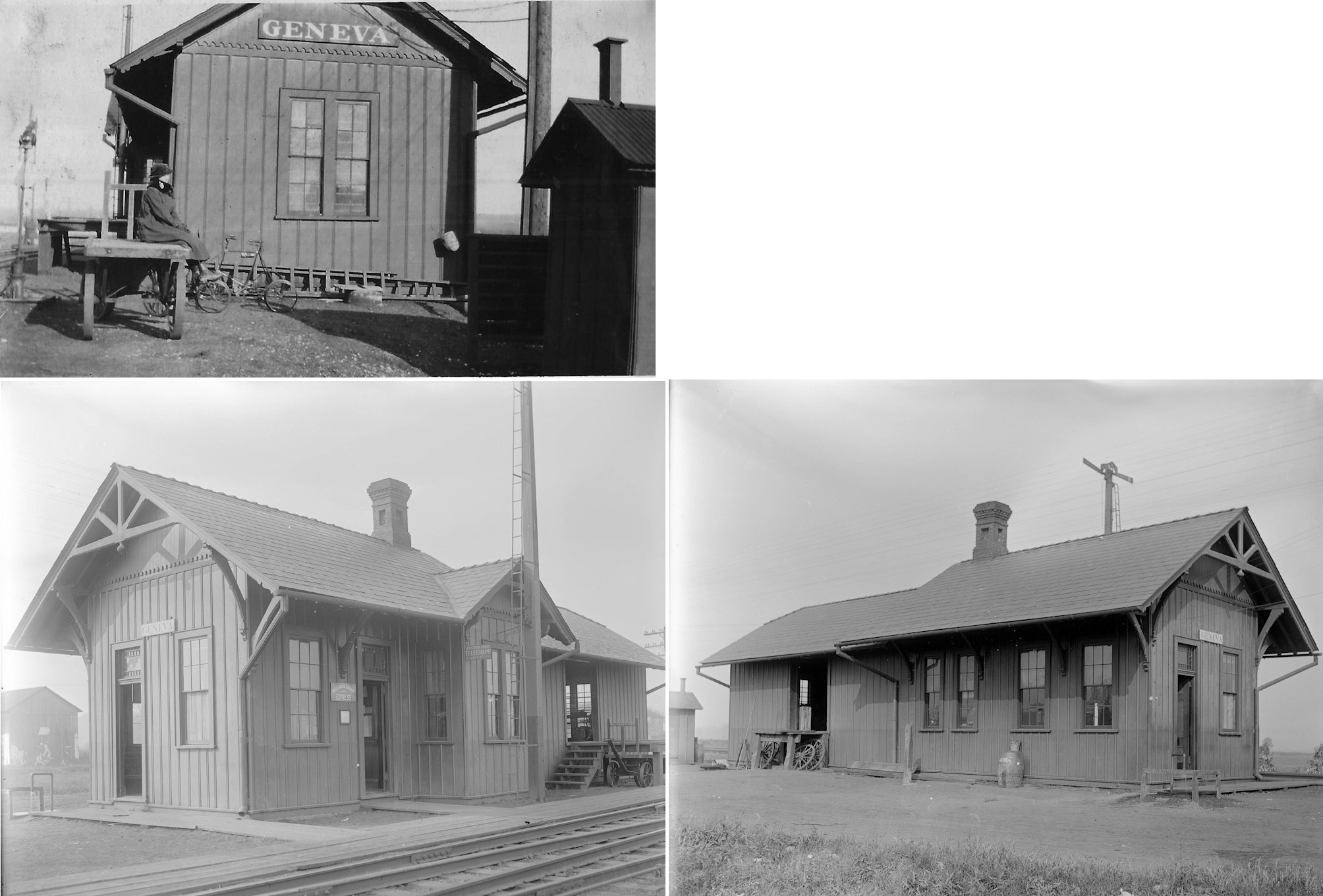
| Geneva | |
This station was west of Geneva Road and north of Mill Road on the south side of the tracks (GPS: 41.571713,-80.223316). | ||||||
| Glynden Station | |
This station was on the north side of Glynden Road on the west side of the tracks at approximately GPS: 41.776302, -79.718532. | ||||||
| Grays Mills (Greytown) |
|
A station is shown here on the 1897 map. It was on the west side of Rosenburg Road on the SW side of the tracks at approximately GPS: 41.681622,-79.755989. | ||||||
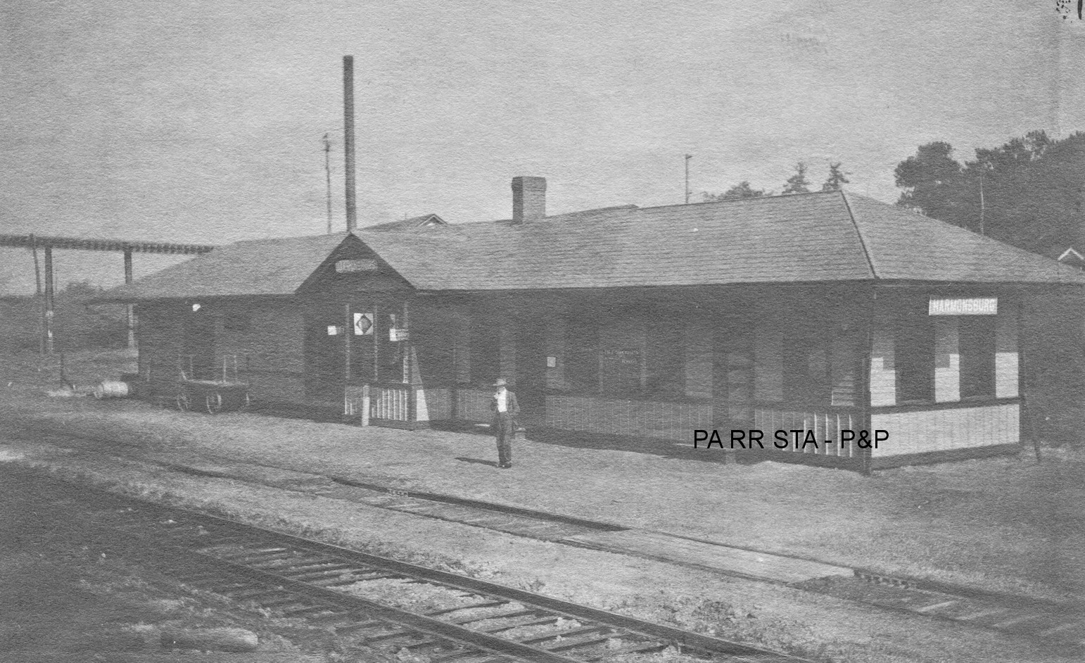
| Harmonsburg Station |
|
The original station here was replaced in 1912 (see below). | ||||||
| Harmonsburg Station | |
This station was on the north side of Harmonsburg Road on the west side of the tracks at GPS: 41.663662, -80.343726. The Meadville, Harmonsburg and Linesville Electric Railway crossed over the tracks near the station as they ran along the north side of the road. This station was built in 1912 (Conneautville Courier, 11-20-1912). According to the Greenville Record-Argus, the station burned down on Sept. 9, 1942. | ||||||
| Harmonsburg |
|
Before the line was acquired by the B&LE, the MRY had its own station near Harmonsburg. This station was located at where Gordon Road crossed the railroad, about 3 1/2 miles south of Harmonsburg. | ||||||
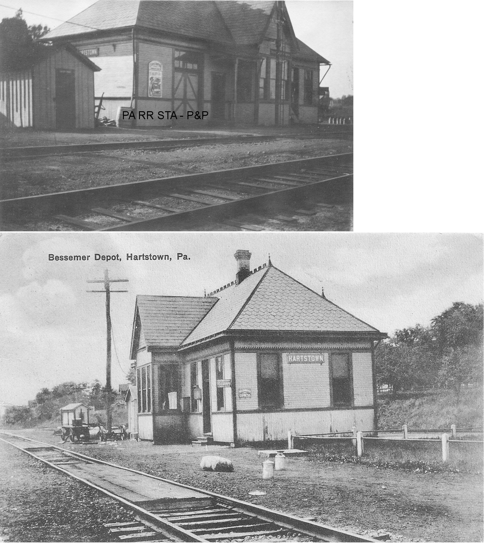
| Hartstown | |
This station was on the north side of US 322/PA18 on the west side of the tracks at approximately GPS: 41.553172, -80.377541. The depot was built here in 1891 when the line was known as the PS&LE (Meadville Evening Republican, 6-30-1891). The 1941 map shows the station on the south side of the road. | ||||||
| Himebaugh | |
This line was originally the Union & Titusville RR a.k.a. "The Pigtail Railroad" (later the PRR's Lakeville Branch) A freight station is shown here on the 1923 PRR List of Stations & Sidings, but no passenger station. It was between Nobles and Riceville. | ||||||
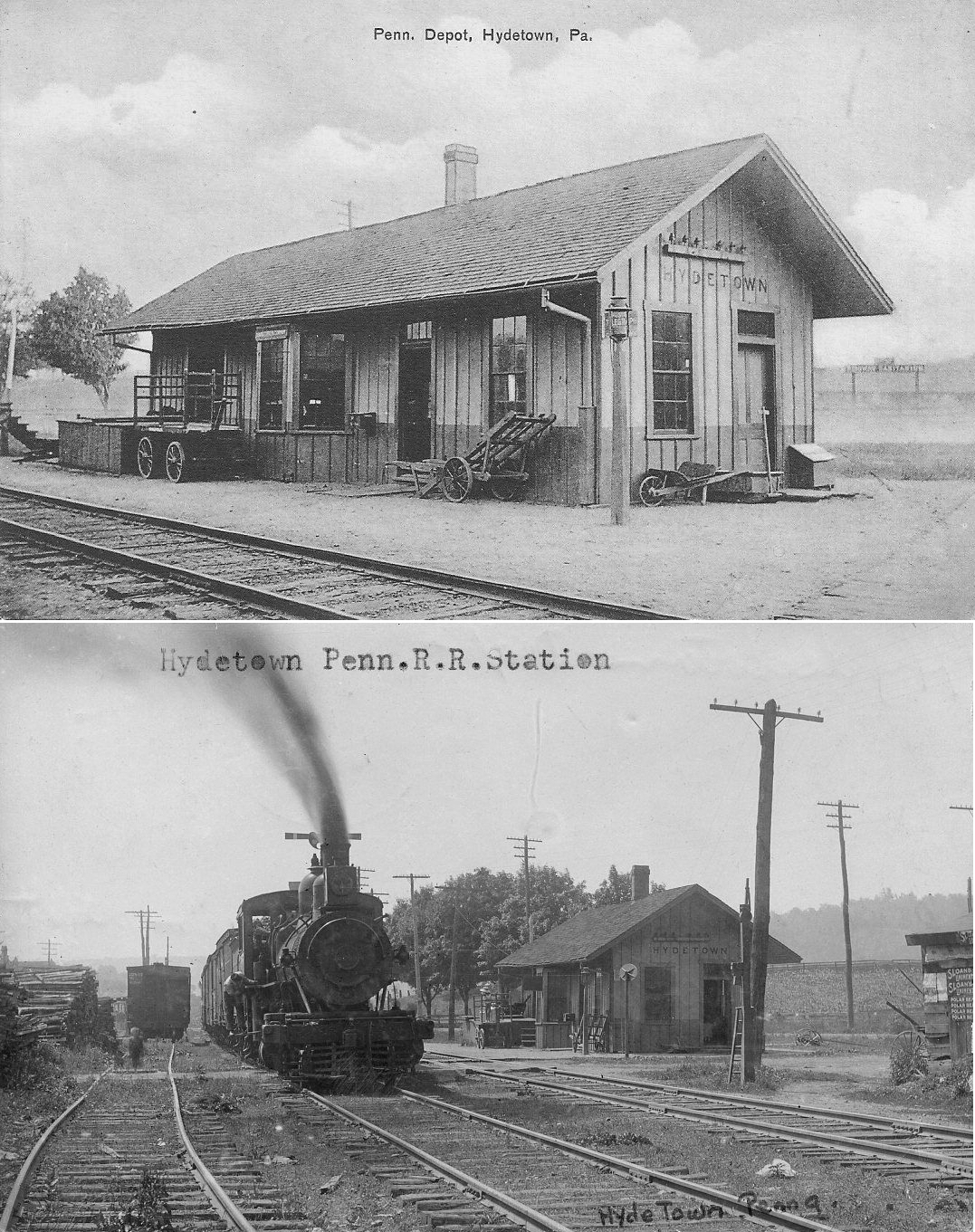
| Hydetown (Oil Creek) |
|
The original OC&AR station was on the NW side of Diamond Street on the SW side of the tracks (GPS: 41.651006,-79.724114). The station was torn down 1951. | ||||||
| Lincolnville | |
This line was originally the Union & Titusville RR a.k.a. "The Pigtail Railroad." A freight station is shown here on the 1923 PRR List of Stations & Sidings, but no passenger station. | ||||||
| Linesville | |
This station was on South Pymatuning Street just south of East Franklin Street (GPS: 41.653515,-80.422636). The station was also used by the B&LE as the Meadville & Linesville RR ended near the station. The joint use of the station began in 1901. The E&P had an operating lease over the M&L from 1881-1884. In the 1880s, the E&P train going south from Erie met the train going north from Pittsburgh at Linesville each evening at 6 p.m. (Greenville Advance Argus, 6-11-1885). "P" tower was .2 mile from the station. | ||||||
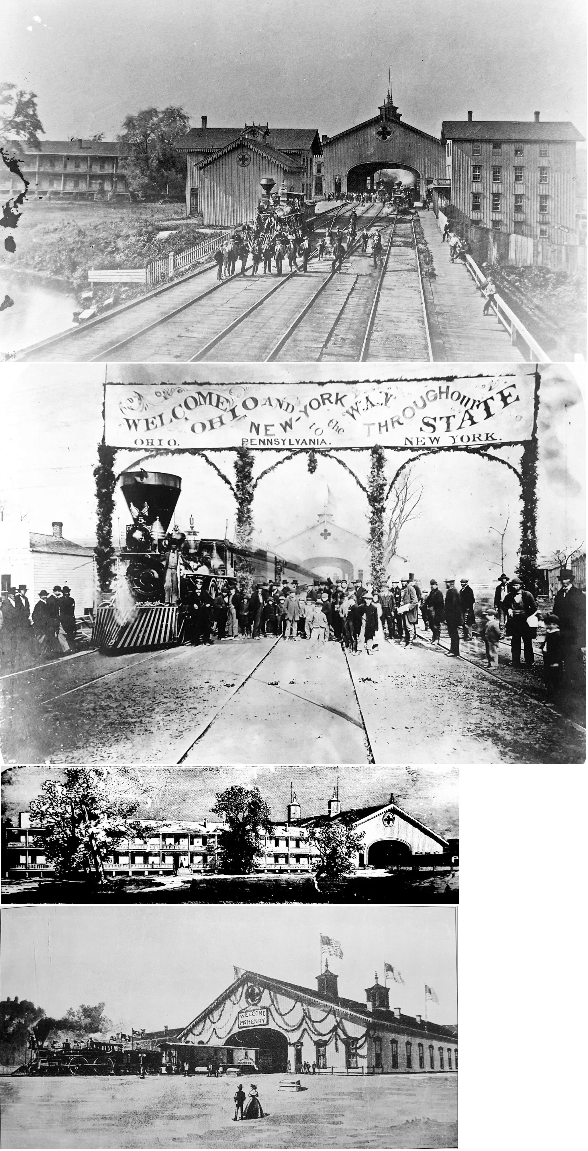
| Meadville | |
Predecessor of station listed below. It was at the NW end of Chestnut Street (when Chestnut was originally extended through to this location) at GPS: 41.639244, -80.157499. The depot was dismantled in 1893 to make way for the new NYP&O station listed below. The building that extends to the left in the picture is an old hotel that was gone by 1886. As the central dining point on the line, it also featured a massive 200-foot long dining hall with 35-foot ceilings. The railroad had plans to remodel the station in the 1890s, but it was determined that the costs would be equal to building a finer structure situated to expose the railroad to less liability from fire and accidents. | ||||||
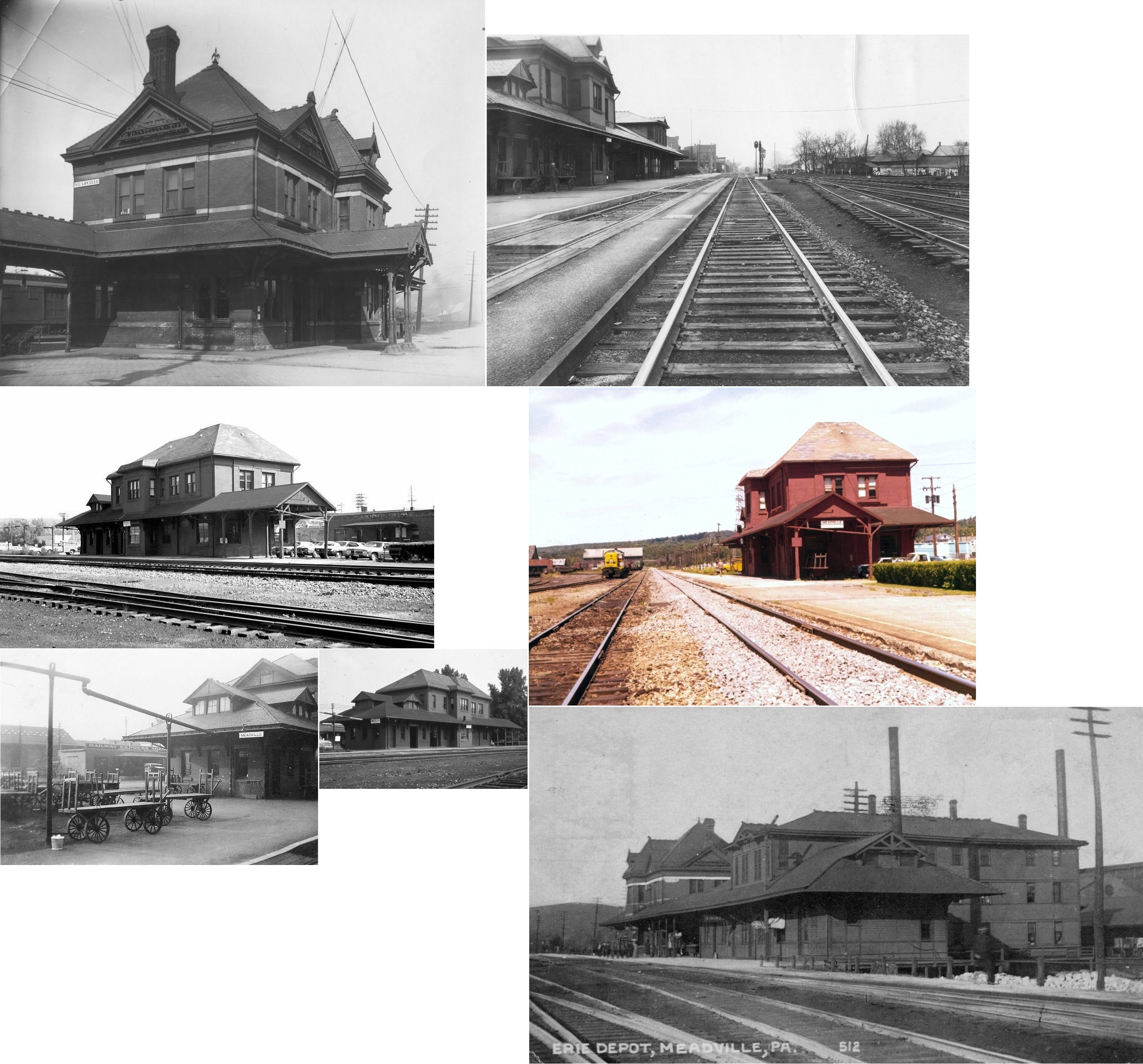
| Meadville | |
This station sat at the NW end of Chestnut Street (GPS: 41.639222, -80.157346). It was built in 1893 on the site of the old A&GW station (listed above), and was demolished on July 11, 1972. It opened in November, 1893 (Meadville Evening Republican, 1-02-1894). | ||||||
| Meadville | |
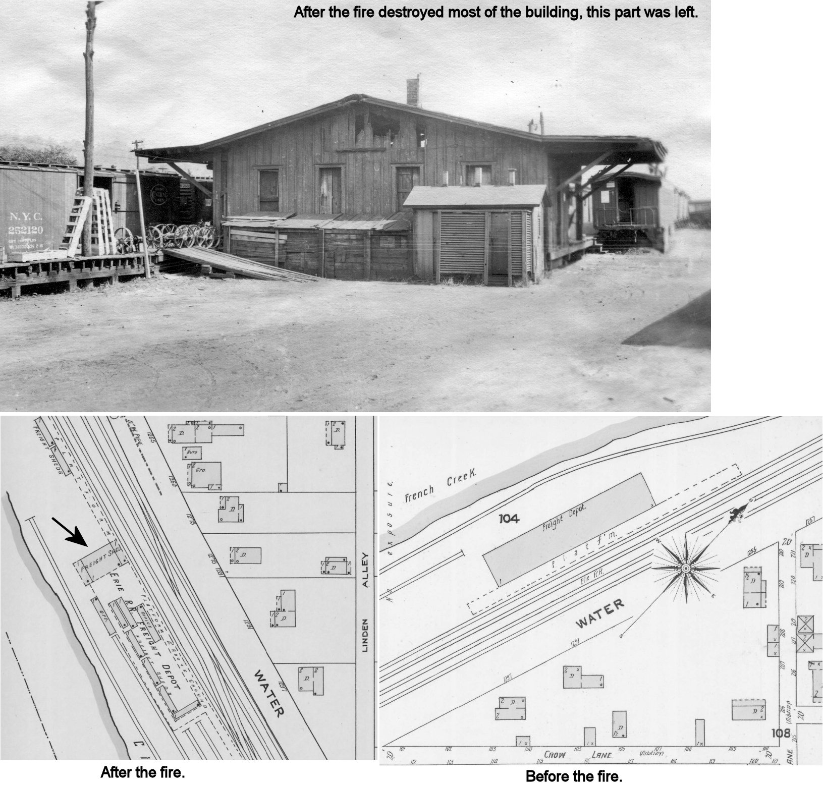
There was a large freight station, built in 1875, on Water Street just south of Linden Street (GPS: 41.628756,-80.158181). It burned down on the morning of December 12, 1914 (The Meadville Evening Republican, 12-12-1914). What you see in the photo here is what reamined of the end of the station (in the photo you can see fire damage on the end of the building). Just beyond the part of the building that remained were old boxcars and passenger cars used as a temporary freight station until the new station was built in 1922 (see existing freight station listed above). | ||||||
| Meadville |
 |
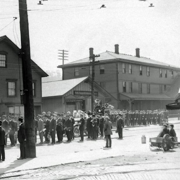
In the photo the building in the center is the Meadville Wells Fargo Express Agency freight depot. The building on the right is the Erie RR division office that sat just SW of the Erie station. It was the former Terry Hotel. The Wells Fargo Express office used to sit next to the tracks (hence the eaves on the right of the building), but was moved back to the location shown in the photos to make room for the hotel's expansion in the late 1800s. | ||||||
| Meadville
Junction |
|
This station was located at GPS: 41.637104,-80.347781 one-half mile east of Porter/Alter road. There are no roads to that location today. This is where the Pittsburgh Shenango and Lake Erie RR crossed the Meadville and Linesville Railroad. The station, which included a lunch room, was built in 1892 when the PS&LE was built through here from Osgood (near Greenville) heading towards Albion. The station was closed to passenger traffic on September 29, 1935. | ||||||
| Mercer Pike Station |
|
This station was not shown on any maps until the 1941 county map. It was on Mercer Pike at approximately GPS: 41.591511, -80.159897. | ||||||
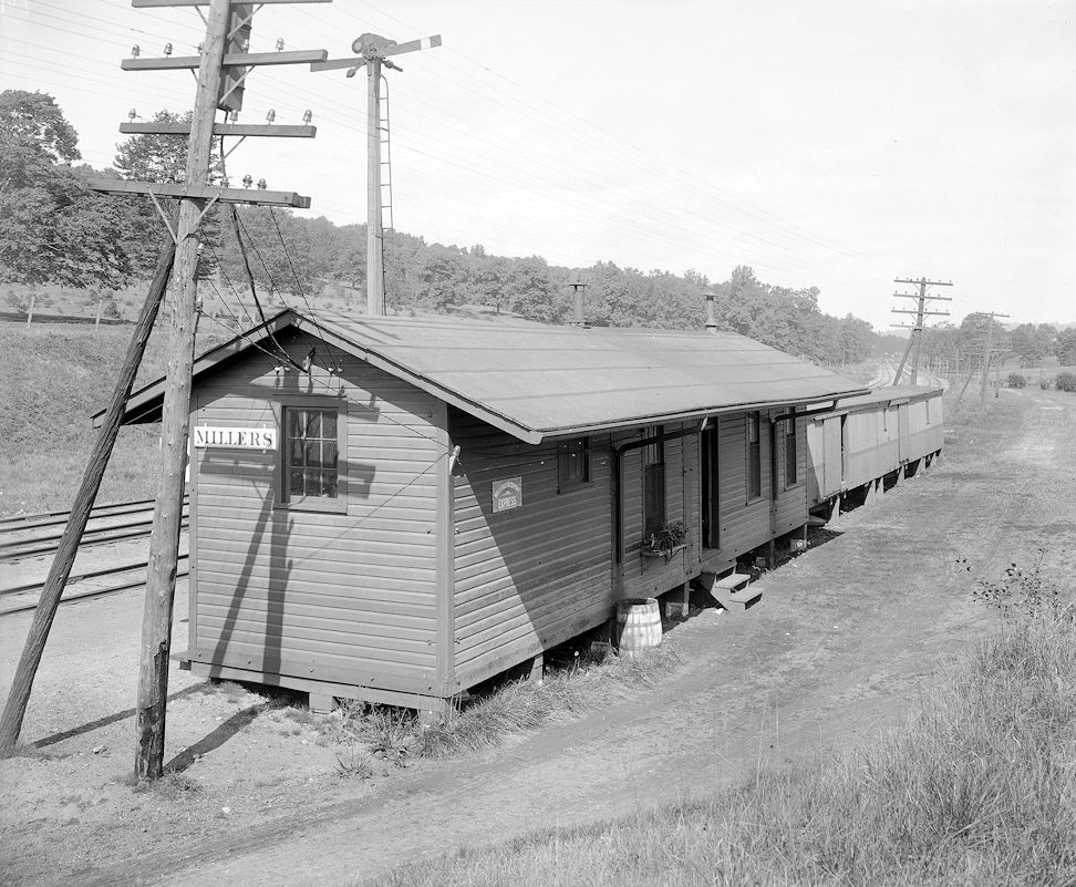
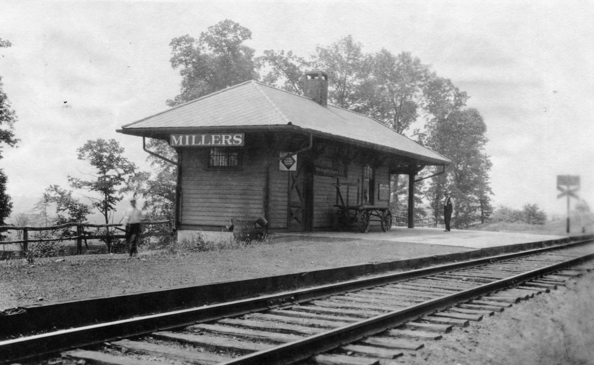
| Millers Station | |
The first station here was off Cherry Hill Road at GPS: 41.815003, -79.991238. | ||||||
| Millers Station | |
During the double tracking project between Meadville and Corry, the Erie built a new, small station on the highline in 1913. The old station remained and the two stations were connected by a driveway. The new station was at GPS: 41.816994, -79.991045. There was also a small freight house (which may have been an old boxcar) near the new station. The driveway is still accessible from Cherry Hill Road as of 2019. | ||||||
| Nobles | |
This line was originally the Union & Titusville RR a.k.a. "The Pigtail Railroad" (later the PRR's Lakeville Branch) A freight station is shown here on the 1923 PRR List of Stations & Sidings, but no passenger station. | ||||||
| Riceville | |
This station was on the north side of PA77 on the west side of the tracks at approximately GPS: 41.776729, -79.804631. A freight station is shown here on the 1923 PRR List of Stations & Sidings, but no passenger station. | ||||||
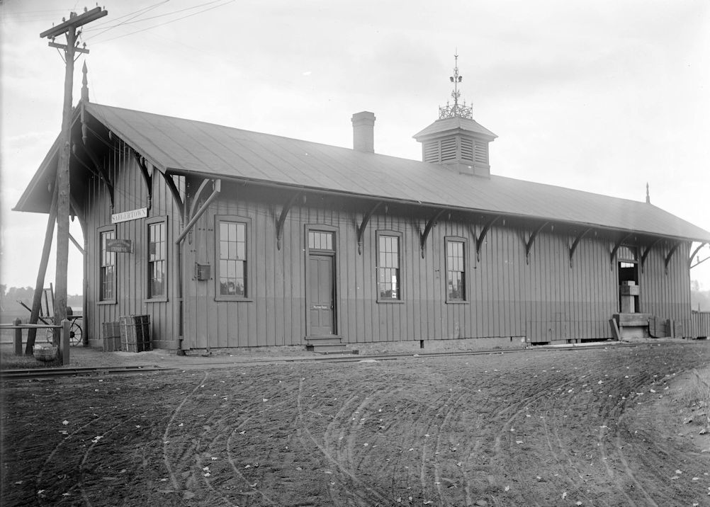
| Saegertown | |
This station was built in 1872. It was on the south side of Mill Street on the west side of the tracks at 41.716725,-80.144373. In 1912-1914 the Erie Railroad double tracked the line between Meadville and Corry to eliminate steep grades and increase traffic. Several stations along the line were either moved or replaced. When the new line went into operation, the Saegertown station was still in its original location with a boxcar body and platform serving as a temporary station on the new highline. Two years later the station was moved from its original location to the new track that was 12 feet above the old grade. The station was then given a thorough remodel and stucco facelift when it was moved, but the distinctive cupola in the middle remained. | ||||||
| Shadeland | |
According to the 1912 and 1926 map this station was on the north side of Shadeland Road on the west side of the tracks at approximately GPS: 41.816085, -80.382522. The 1941 map shows the station on the south side of the road (but these maps are not exact). | ||||||
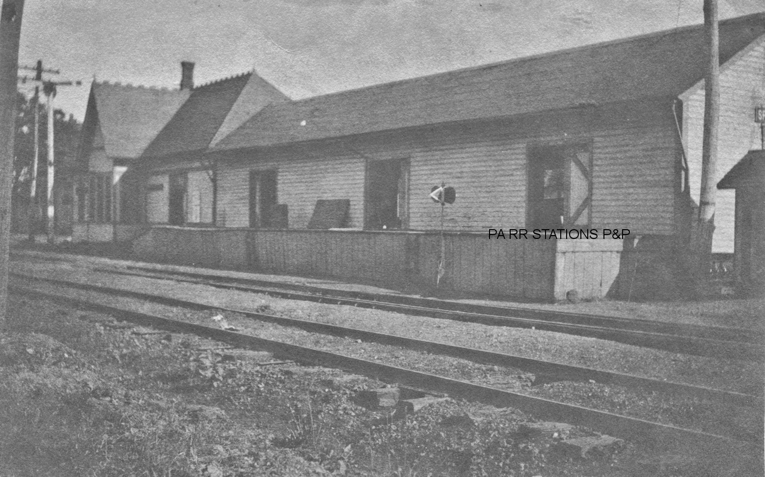
| Shadeland Station |  |
Although the 1912 and 1926 maps do not show a station here, there is one on the 1941 map. It was on the north side of Shadeland Road at approximately GPS: 41.816202, -80.394675. The freight station and a coal house here burned down on August 25, 1916 (Conneautville Courier, 8-30-1916). | ||||||
| Shaw's Landing (Shaw Station) |
|
A depot is shown here on the 1876 county map and Erie valuation records indicate that was the year it was built. It is also shown on the 1941 map near the intersection of US 322 and Kebort Road at approximately GPS: 41.561166, -80.109025. | ||||||
| Shermansville | |
Earlier maps (1912, 1926) place this station on the south side of US 6 on the west side of the tracks (GPS: 41.627420, -80.376861). The 1941 map places this station on the east side of T-378 at approximately GPS: 41.630008, -80.372905. The B&LE crossed the old Meadville, Conneaut Lake and Linesville RR (later to become part of the B&LE) near here. This may have been the same station listed below as the railroads had been combined by then. | ||||||
| Shermansville |
|
The Meadville & Linesville Railway had a station at Shermansville prior to being purchased by the PS&LE (B&LE). It was built around 1881-82. There was no station here at first when the line opened in 1881, but due to good numbers of people boarding here, the RR soon built one. It was located on the east side of Township Road 378/Beagle Road at GPS: 41.630015, -80.372855. | ||||||
| Spartansburg | |
The original station was on the north side of Main Street on the west side of the tracks (GPS: 41.824425, -79.686289) and was of Oil Creek & Allegheny River RR vintage. In 1913 the station was moved the north end of Water Street at GPS: 41.826144, -79.687366 due to lowering the grade of main street by six or seven feet. | ||||||
| Springboro Station | |
This town was originally known as Spring and the station as Spring Station. The original location of the depot was on the north side of Beaver Street on the west side of the tracks at approximately GPS: 41.800874, -80.390663. At some point it was moved to the east side of the tracks. The community partially funded the building of the station when the line was built. It was erected by local carpenter L.K. Chapman. After the rise of automobiles and trucks, the station was closed on October 1, 1924 due to lack of business (Conneautville Courier, 10-1-1924). | ||||||
| Springboro | |
According to B&LE valuation records, this station was built in 1891. | ||||||
| Stony Point (Evansburg Sta.) |
|
This station was on the south side of Township Road 409 on the NW side of the tracks at GPS: 41.574153, -80.326503. It was originally known as Evansburg Station. | ||||||
| Summit Station (Center Road) |
|
Not to be confused with the WNY&P RR station in Erie County. Originally known as Summit Station and later as Center Road (as shown on the 1923 timetable), this depot was on the north side of West Center Road at approximately GPS: 41.712063, -80.417635. | ||||||
| Titusville | Union & Titusville RR |
The U&T freight station was was in the center of the block between Arch Street and Water Street. The U&T connected the Philadelphia & Erie RR with the A&GW at Union. | ||||||
| Titusville | |
There was an early pre-1870 station here which was likely of frame construction. | ||||||
| Titusville | |
This Oil Creek & Allegheny River RR (later WNY&P) station was between South Franklin and South Washington Streets on the north side of the tracks (GPS: 41.623984,-79.674397). It was built in 1870 and torn down in the 1960s. | ||||||
| Titusville | |
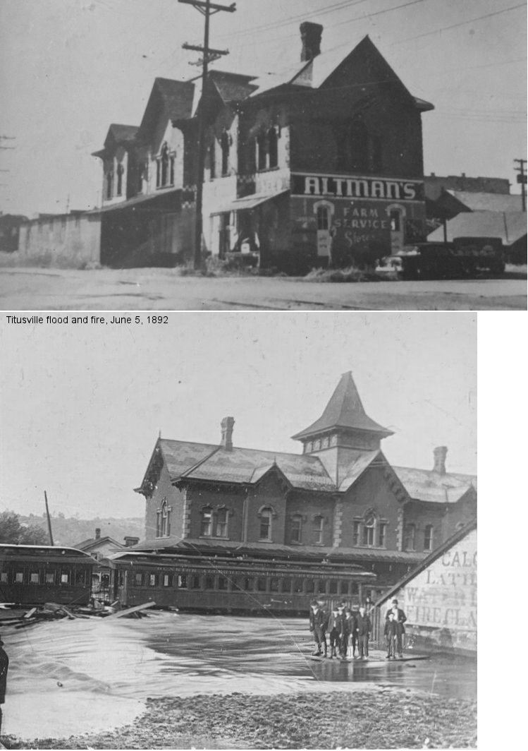
An earlier frieght station was on the south side of West Mchanic Street between Perry and Monroe Streets. This station burned down on June 5, 1892 during a flood which ruptured oil tanks. The oil on the surface of the water subsequently caught fire and burned the freight depot and 38 railroad cars nearby. The new 1893 station was built just to the east of where this station once stood at GPS:41.624086, -79.678328. | ||||||
| Titusville | |
This station was on the NW corner of Martin and Water Street (GPS: 41.625324,-79.671843). The station was closed in 1937 and torn down in 1966. | ||||||
| Titusville | |
There was also a freight station on Water Street east of Martin Street (GPS: 41.62534,-79.670727). The 1893 map shows a very small freight station here with a large platform. The 1898 map shows a much larger building so either a new one was built or the old one was expanded sometime between 1893-1898. | ||||||
| East Titusville Station | |
This station was on the west side of Johnson Avenue on the south side of the tracks. This was at approximately GPS: 41.62145,-79.642886. | ||||||
| Tryonville | |
This predated the station that is still standing. It was located north of Five Corners Road, but south of the stream there. It is shown on the 1876 map, whereas the next generation station is shown at its more northern location on the 1897 map. | ||||||
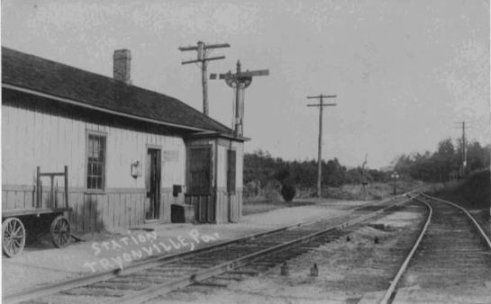
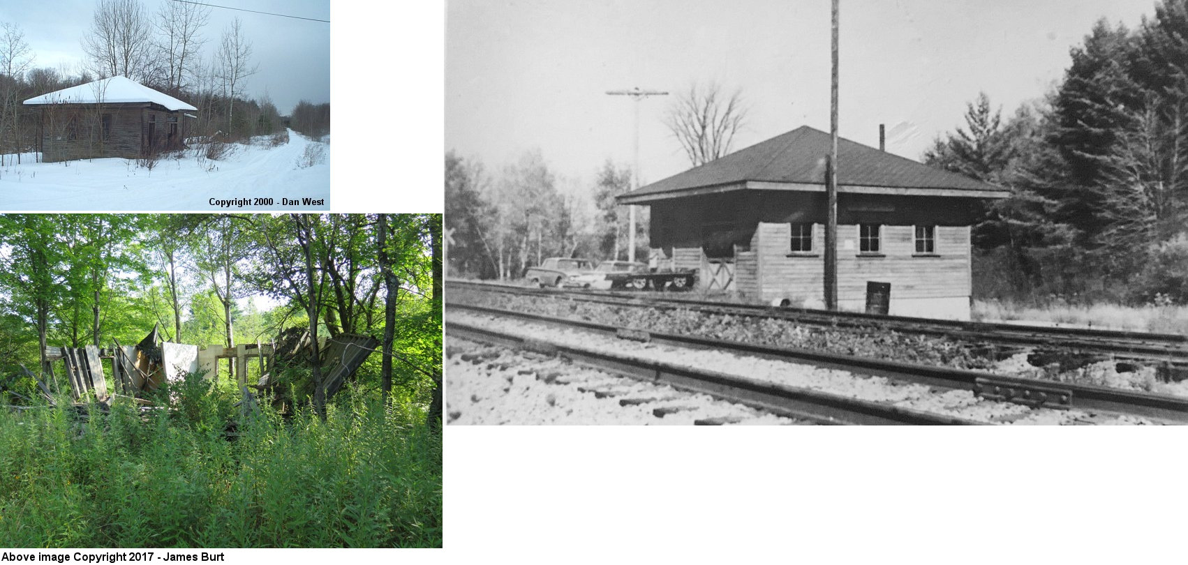
| Tryonville | |
This station was located at Station Road (GPS: 41.712104,-79.773174). The building collapsed and the ruins were still there as of 2017. This was the beginning of the "Pigtail" or Lakeville branch (formerly the Union & Titusville RR) that went north to Canadohta Lake. In the early 1900s two train per day went from Tryonville to the lake. From 1906-1908 a private businessman, C.N. Payne leased the little-used line from the PRR to facilitate the transport of passengers from Tryonville (passengers took the regular PRR train from Titusville up to Tryonville) to the lake where the Canadohta Lake Club held parties and gatherings. The trains also stopped at Riceville and Lincolnville. | ||||||
| Turnersville (Turner Station) |
 |
This 6'x10' shelter/station was on the SE side of State Road on the north side of the tracks at approximately GPS: 41.507372, -80.482361. It was built in 1906. | ||||||
| Turnersville | |
This location and station was originally known as Leans Corners. This station was in the vicinity of the intersection of East Lake Road and East State Road around GPS: 41.515324, -80.464504. | ||||||
| Venango | |
The original station here burned down on April 20, 1879 (Conneautville Courier, 4-24-1879). | ||||||
| Venango | |
This station was on what was formerly Woodcock Road at approximately GPS: 41.769505, -80.108565. It was built in 1881 according to Erie valuation records. | ||||||
| Watsons Run | |
Shown on the 1897 map, on the 1912 and 1926 maps the station is located on the west side of Bailey Road on the south side of the tracks at GPS: 41.590415, -80.217462. It is not shown on the 1941 map. There was a station here when the line was the Meadville & Linesville RR. | ||||||
| Westford | |
This may have originally been a store/station combo. It was on the north side of Westford Road on the east side of the tracks at approximately GPS: 41.557627, -80.478838. "WF" cabin was near the station. | ||||||
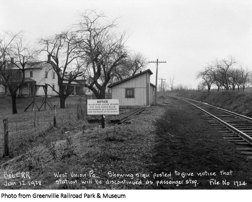
| West Union (Keborts Corners) |
|
This station was shown as West Union on the 1897 map. It was located east of U.S. 19 and south of the corner of Vernon Drive and Franklin Street at GPS: 41.592386,-80.193243. The station is not on maps from 1912 on, but it wasn't actually closed until 1928. | ||||||
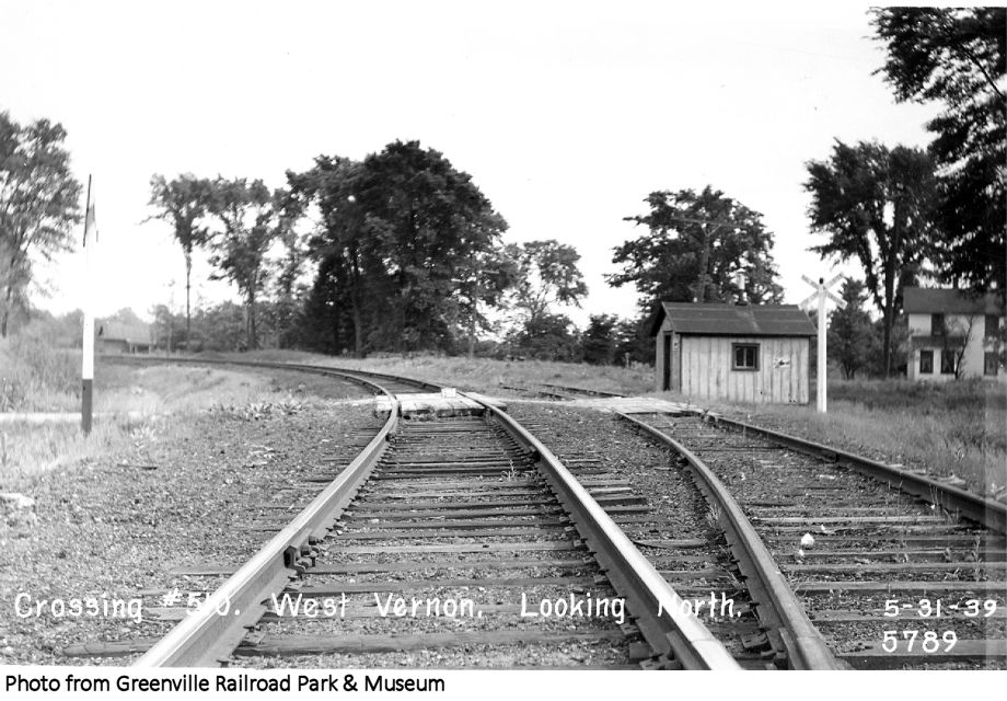
| West Vernon Station |
|
This station was the first station east of Conneaut Lake. It was on McMichael/Brown-Hill Road SW of West Vernon Road at GPS: 41.597344,-80.265427. There is no town there today (there may have never been one) as this is part of State Game Lands 213. This station is shown on the 1897 county map. | ||||||
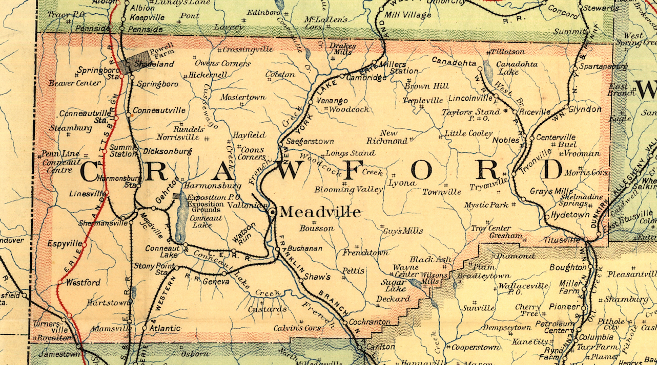
| 1895 CRAWFORD COUNTY RAILROAD MAP | ||||||||
 |
||||||||
| Notes About Existing
Stations... Cochranton (A&GW) - Moved. Here is an old photo of the station in its original location on the south side of Adams Street (PA173). It was located at GPS: 41.518550, -80.052781. Erie valuation records from 1919 list the station's build date as 1876, although locals claim it was built in 1862 (the line to Cochranton was completed from Franklin in 1863). It was moved from its original location to the fairgrounds in 1984. Meadville (B&LE) - This building is the original Meadville Railway (later Meadville & Linesville RR, later PS&LE in 1891) station plus a 50' addition that was made by the B&LE in 1907. The Erie & Pennsylvania RR also used this station for the first three years of its existence as they had an operating lease on the line which ended in 1884. In fact, it was an E&P train that made the first trip on this line from Linesville to Meadville before the station opened. The station housed Meadville Farm & Garden from 1969-2019. Some tracks still exist around the station area. Two bumpers are visible from Mead Ave. The B&LE tracks are still in limited use nearby. To the north they go to the former Avtex Fibers plant to serve Andover Industries. To the south they still extend to Dad's Dog Food. Meadville Farm & Garden went out of business in February 2018 and The French Creek Valley Railroad Historical Society purchased the building in December 2018. The building has been be converted into a museum and community center and had a grand opening in the summer of 2022. For more about the depot, its history, and visiting the site check out: https://www.fcvrrhs.org |
||||||||