 COUNTY
 COUNTY
|
|
||||||||
| EXISTING STATIONS | ||||||||
|---|---|---|---|---|---|---|---|---|
| Station Name |
Original Railroad | Current Location |
Type | Current Use |
Date Built |
Track Status |
Building Material |
More Info |
| Ironton |  |
Bobby Bare Boulevard and Park Avenue | C | Business | 1907 | In Use | Brick |
|
| STATIONS OF THE PAST | ||||||||
| Station Name |
Original Railroad |
Notes | ||||||
| Bartles Station |  |
|||||||
| Campbell |  |
|||||||
| Centre Station |  |
|||||||
| Coal Grove |  |
This station was located on the southwest side of the Ironton & Burlington Pike (later U.S. 52). | ||||||
| Culbertson |  |
|||||||
| Dean |  |
Dean was on SR-373 (Texas Hollow Road) between SR-93 and Dean Forest Road. | ||||||
| Eifort |
 |
This is in the NW corner of the county. | ||||||
| Ellison |  |
This was at the end of the two-mile Etna Branch. It was likely named after Cyrus Ellison who was the president of the Iron Railroad. | ||||||
| Etna (East Ironton) |
 |
This was the location of the old "Big Etna Furnace." This location was also served by the Scioto Valley RR and The Ironton and Petersburg Street Railway/Ohio Valley Electric Railway. Most likely it was named "Petersburg" before the N&W merged with the Scioto Valley in 1896. | ||||||
| Etna (Pedro) |
 |
|||||||
| Etna Furnace |  |
This was on the two-mile Etna Branch. | ||||||
| Firebrick |
 |
This station was in the NW corner of the county. | ||||||
| Gold Camp (Goldcamp) |
 |
The land for the station was donated by Ferdinand H. Goldcamp (1837 – 1916) and Mary (Monnig) Goldcamp (1839 – 1916). The town was on SR-650 between SR-522 (Superior – Lawrence Furnace Road) and Little Pine Creek Road. | ||||||
| Iron Rock |
 |
Iron Rock was just west of Hanging Rock and is shown on the 1887 Lawrence County Atlas. | ||||||
| Ironton |  |
The C&O passenger and freight stations were adjacent to each other on a double-track spur that ended at the freight station. This was located on the southeast side of Railroad Street between North 2nd and North Front Streets. The original stations were torn down sometime between 1910-1915 and then the DT&I freight station was constructed at this location (see listing below). Both the C&O and DT&I maintained offices on this block, but by 1928 all C&O facilities at this location were closed. The C&O also had a freight house on the southwest corner of Lawrence and North 2nd. For an evolution of this area and various buildings see these maps of the block from 1889, 1893, 1904, 1909, 1916, and 1928. | ||||||
| Ironton |  |
See notes above. | ||||||
| Ironton |
 |
There was a Scioto Valley (N&W) freight house on 1st Street (now Front Street) near the intersection with Monroe Street. It was across the tracks from, and situated between the Belfont Furnace and the Kelly Nail and Iron Company. | ||||||
| Ironton |
 |
The passenger station was on the southern corner of North 2nd Street and Railroad Street at GPS: 38.535847, -82.687195. The freight station was just SW of the passenger station at GPS: 38.535746, -82.687479 on the corner of Railroad Street and Front Street (now gone). These are shown on the 1887 Lawrence County Atlas. | ||||||
| Hanging Rock |  |
This station was just off Main Street (Railroad Street) to the west of the Hanging Rock Iron Company's Hamilton Furnace | ||||||
| Moulton |  |
Moutlon was near the intersection of SR-93 and Waterloo-Mt. Vernon Road. | ||||||
| North Kenova |  |
This 12'x24.5' station and telegraph office was moved to South Point in 1902 (according to the book Norfolk and Western in Ohio by Alex Schust, 2005) . | ||||||
| Olive Furnace |  |
|||||||
| Royersville |  |
|||||||
| South Point |  |
This station was formerly known as Buckeye Ordinance Works. | ||||||
| Vesuvius |  |
This station was just south of Royersville. | ||||||
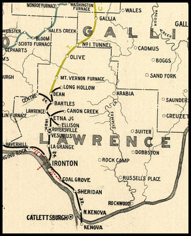
| 1898 LAWRENCE COUNTY RAILROAD MAP | ||||||||
 |
||||||||
|
Notes About Existing Stations... Ironton (N&W) - On National Register of Historic Places. |
||||||||