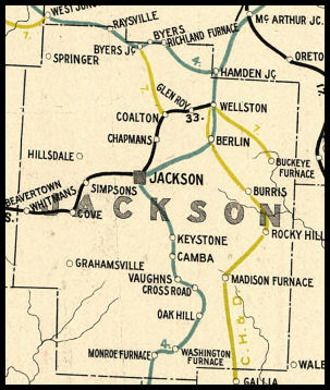
 COUNTY COUNTY
|
|
||||||||
| EXISTING STATIONS | ||||||||
|---|---|---|---|---|---|---|---|---|
| Station Name |
Original Railroad | Current Location |
Type | Current Use |
Date Built |
Track Status |
Building Material |
More Info |
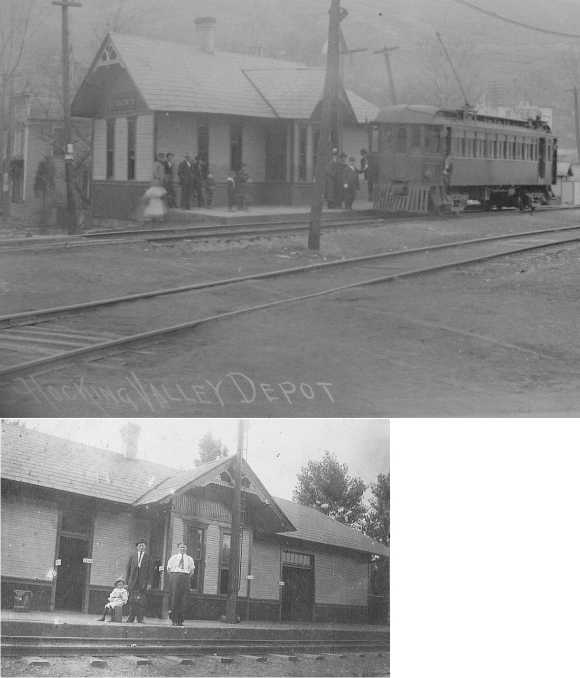
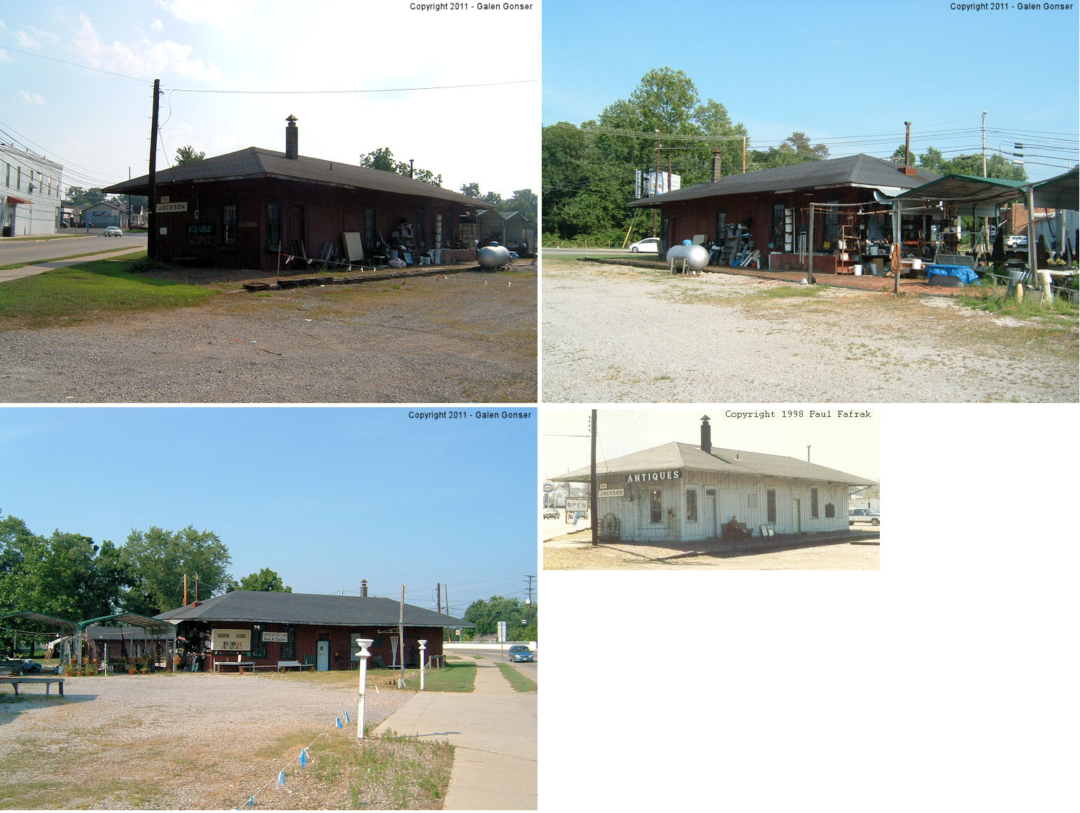
| Jackson |
 AND  |
East Broadway northeast of Water Street (GPS: 39.053246, -82.634882) |
P | Museum | 1894 | In Use | Wood |
|
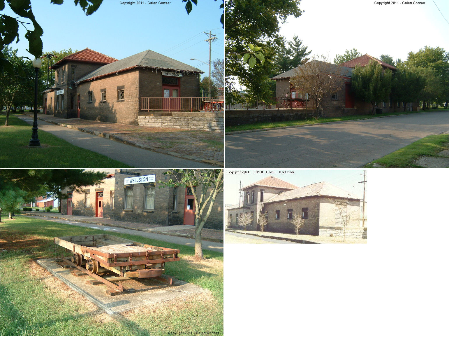
| Wellston | AND |
North Railroad Avenue between East 1st and East 2nd Streets. (GPS: 39.122295,-82.535632) |
C | Civic | 1895 | In Use | Brick |
|
| STATIONS OF THE PAST | ||||||||
| Station Name |
Original Railroad |
Notes | ||||||
| Abmac |
 |
|||||||
| Barner |
|
|||||||
| Berlin Crossroads |
|
In 1875 The Marietta & Cincinnati station was on the south side of what is now Fairgreens Road. It was on the east side of the tracks. John Stewart was the station agent in 1875. | ||||||
| Blackfork Junction |
|
Also known as Samsonville, Washington Furnace, and Washingtonville in the past. There was a freight station for the Cambria Clay Products brick plant and possibly a passenger station as well. These were on Blackfork Station Road in the vicinity of GPS: 38.861163, -82.600821. | ||||||
| ByerS Junction (Ellsworth) |
|
|||||||
| Camba (Irwins) |
|
|||||||
| Chapan |
|
This station was on the north side of Township Road 938 (Rafferty Road) on the west side of the tracks. The station measured about 12'x25'. | ||||||
| Clay |
|
|||||||
| Crossroad |
|
|||||||
| Coalton | AND |
This station was located on the SE corner of Church and Second Streets (GPS: 39.112747,-82.61023). This station also served the Wellston & Jackson Belt Line. | ||||||
| Coalton |
 |
This station was on the west side of Brodaway Street north of Main Street (GPS: 39.114273,-82.611434). The station sat between the main line and a siding. The back of this photo read "The Coalton depot closed Sept. 1st, 1932. I worked in this office 48-1/2 years. G.E. Christman." | ||||||
| Glen Roy | AND |
This station was on the west side of 1st Street on the north side of the tracks. | ||||||
| Glen Roy |
 |
This station was between 1st and 2nd Streets on the north side of the tracks. The station was gone by 1921. | ||||||
| Grand Crossing |
|
|||||||
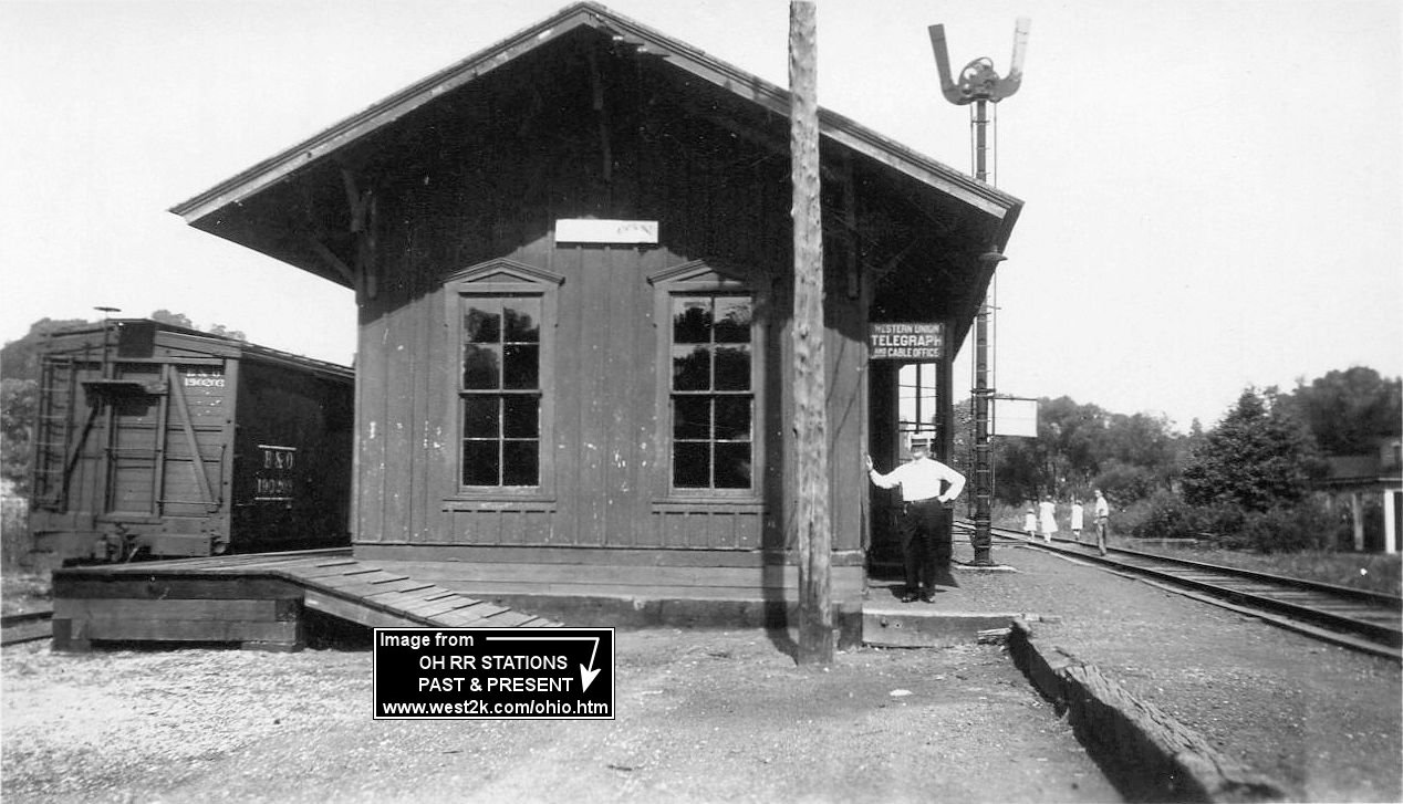
| Hamden |
|
This station was at the east end of Railroad street on the west side of the tracks (GPS: 39.158725,-82.525048). | ||||||
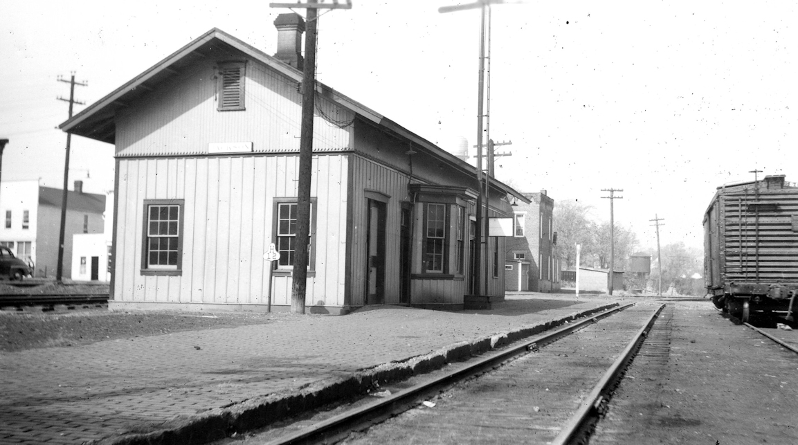
| Jackson |
|
This station was on Bridge Street (SR 93) near Water Street at GPS: 39.055909, -82.638862. It sereved as an antique shop and later a flower shop before being torn down in 2023. | ||||||
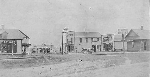
| Jackson |
|
The B&O passenger and freight stations were on the northeast side of Water Street near the intersection of Railroad Avenue (now called Evans Place). The passenger station was sold to a private owner in 1985 and then torn down later that year. | ||||||
| Keystone |
|
|||||||
| Lesmil |
|
This station was between Hamden and Byers Junction. | ||||||
| Meadow Run |
|
|||||||
| Monroe Furnace |
|
Also known as Monroe Station. | ||||||
| Oak Hill |
|
The passenger and freight stations were on Railroad Street between Hill and Main Streets on the east side of the tracks. This stop is listed as "Oak Hill, Welch Settlement" on the 1916 B&O timetable. | ||||||
| Pertrea |
|
In 1875 there was a flag station here where a spur that ran northwest to a mine junctioned with the main line. This location is in the vicinity where SR-788 and Fairgreens Road intersect today NE of Jackson. | ||||||
| Ray (Raysville) |
|
|||||||
| Richland Furnace |
|
|||||||
| Roads |
|
|||||||
| Rocky Hill |
|
|||||||
| Vaughns |
|
|||||||
| Wellston |
 |
The original CW&B station (later B&O) was on the north side of West 2nd Street west of Railroad Avenue (GPS: 39.122091,-82.536032). This was the same site as the second generation B&O station (see listing below). | ||||||
| Wellston |
|
This second generation station was on the north side of West 2nd Street west of Railroad Avenue just across the tracks from the HV station (GPS: 39.122091,-82.536032). There was a freight station on the south side of West 2nd Street (GPS: 39.121646,-82.536059) which was gone by 1921 as a the old CH&D station was put back into service (see below). | ||||||
| Wellston |
|
The third generation station was a combination passneger and freight station that was half way between West 2nd Street and West Broadway Street (just to the north of the station it replaced (see above) (GPS: 39.122911,-82.536619). This was the second generation CH&D station that was originally on the south side of West Broadway near the DT&I station (see below). | ||||||
| wELLSTON |
 |
The original DFt.W&C station (later became the CH&D) was on the north side of West second street at GPS: 39.122062,-82.536941 just west of the original CW&B station. This station is shown on the town map from 1888 and is shown serving into CH&D years on the 1897 map. On the 1904 map, a CH&D turntable is shown at the location of the original station and the new, larger station (see below) is in service down the tracks. | ||||||
| Wellston |
|
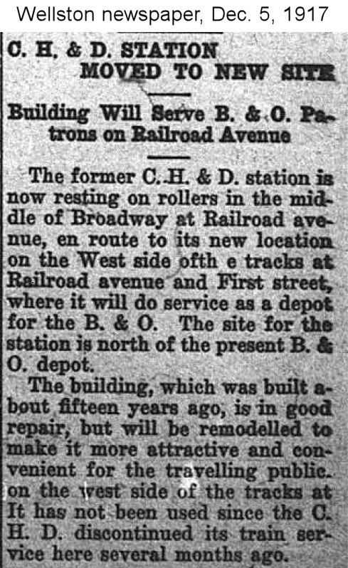
Built in 1902, this second generation station was built a block NW of the original station on this line. It was on the south side of West Broadway Street east of Michigan Avenue next to the Ohio Southern (DT&I) station (GPS: 39.123502,-82.536426). According to a 1917 newspaper article, this station was moved and became the third generation B&O SW station listed above. | ||||||
| Wellston |
|
This station was on the south side of West Broadway Street east of Michigan Avenue next to the CH&D Station (GPS: 39.123618,-82.537048). | ||||||
| 1898 JACKSON COUNTY RAILROAD MAP | ||||||||
 |
||||||||
|
Notes About Existing Stations... Jackson (Jackson & Wellston Belt) - This station was built by the Wellston & Jackson Belt Railway in 1894 or 1895. The W&J Belt was owned by the C&O and was an interurban electric. That interurban line ended service in 1915 and the C&O made a coal carrying road out of it. The B&O was next to the C&O tracks but the Jackson B&O station was about 300 yards south and on the other side of the tracks. The B&O and B&O SW, DT&I, C&O and CH&D and even the Iron Railroad from Ironton went into the Jackson/Wellston coal fields in the late 1800s and early 1900s. Most ran tracks within spitting distance, minimum, to rock throwing distance, maximum throughout this area. Across the tracks to the west of the C&O depot in Wellston was the two story CH&D depot. South of them was the DT&I and south of it was the B&O. Wellston (CHV&T) - Restored. Now a community center. Was also used by the Wellston Jackson Belt Railway. |
||||||||