 COUNTY COUNTY
|
|
||||||||
| EXISTING STATIONS | ||||||||
|---|---|---|---|---|---|---|---|---|
| Station Name |
Original Railroad | Current Location |
Type | Current Use |
Date Built |
Track Status |
Building Material |
More Info |
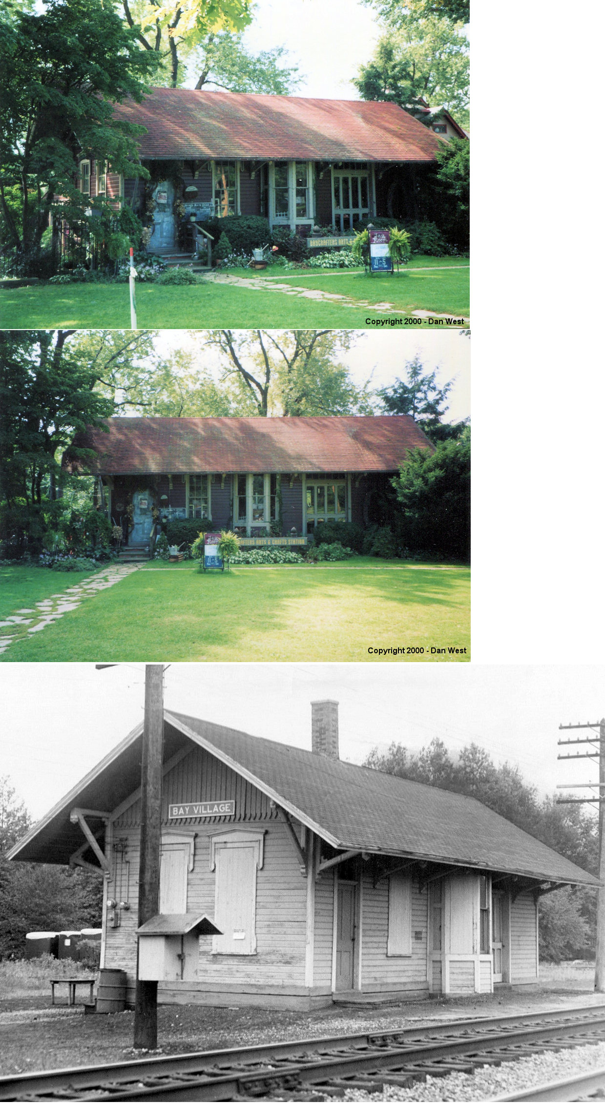
| Bay
Village (Dover) (N. Dover) |
 |
28611 Lake Road in Huntington Park (GPS: 41.488553, -81.937156) |
C | Business | 1882 | None | Wood |
|
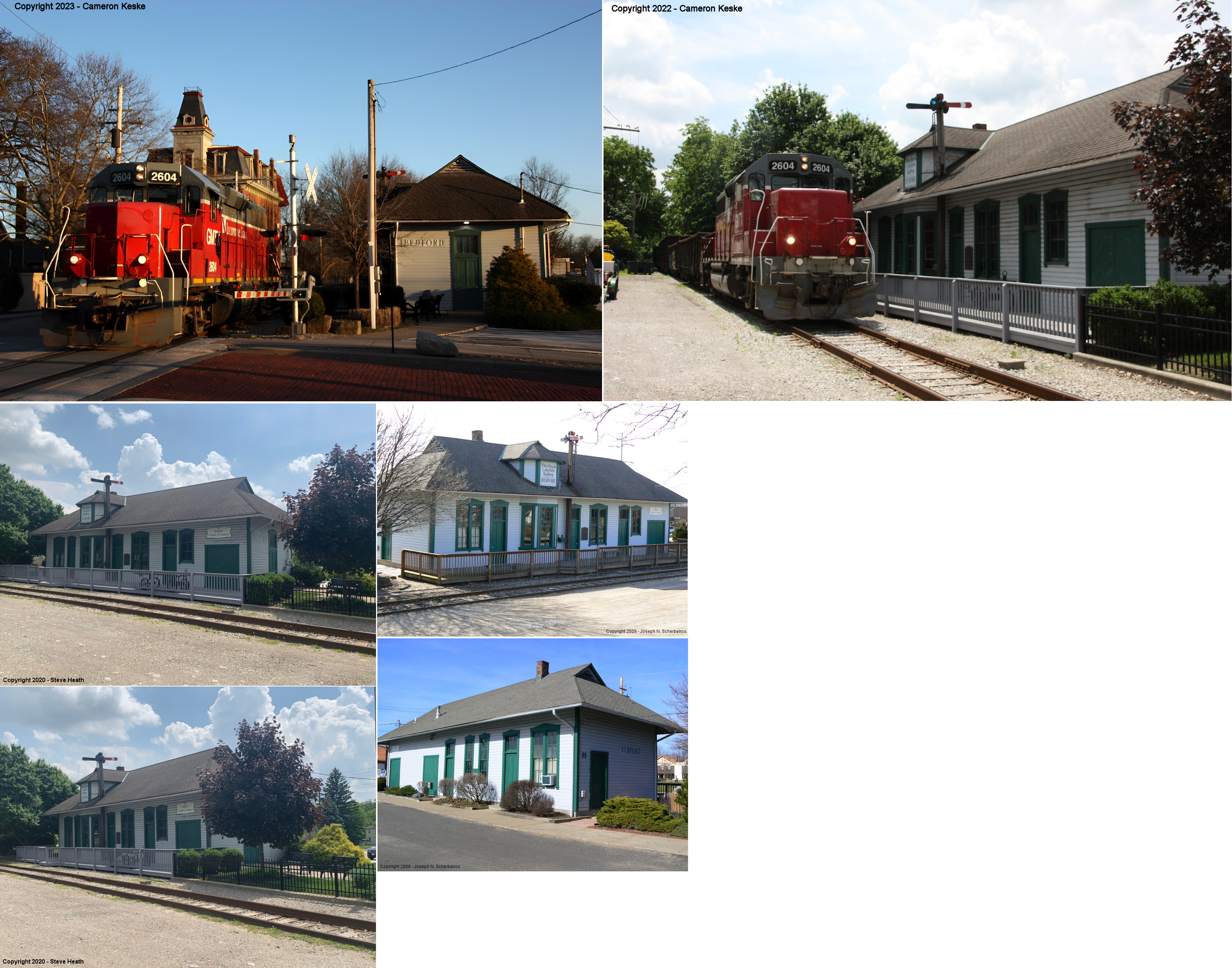
| Bedford |
 |
On Town Square between North Park and South
Park Streets. (GPS: 41.390232, -81.535301) |
C | Civic | 1882 | In Use | Wood |
|
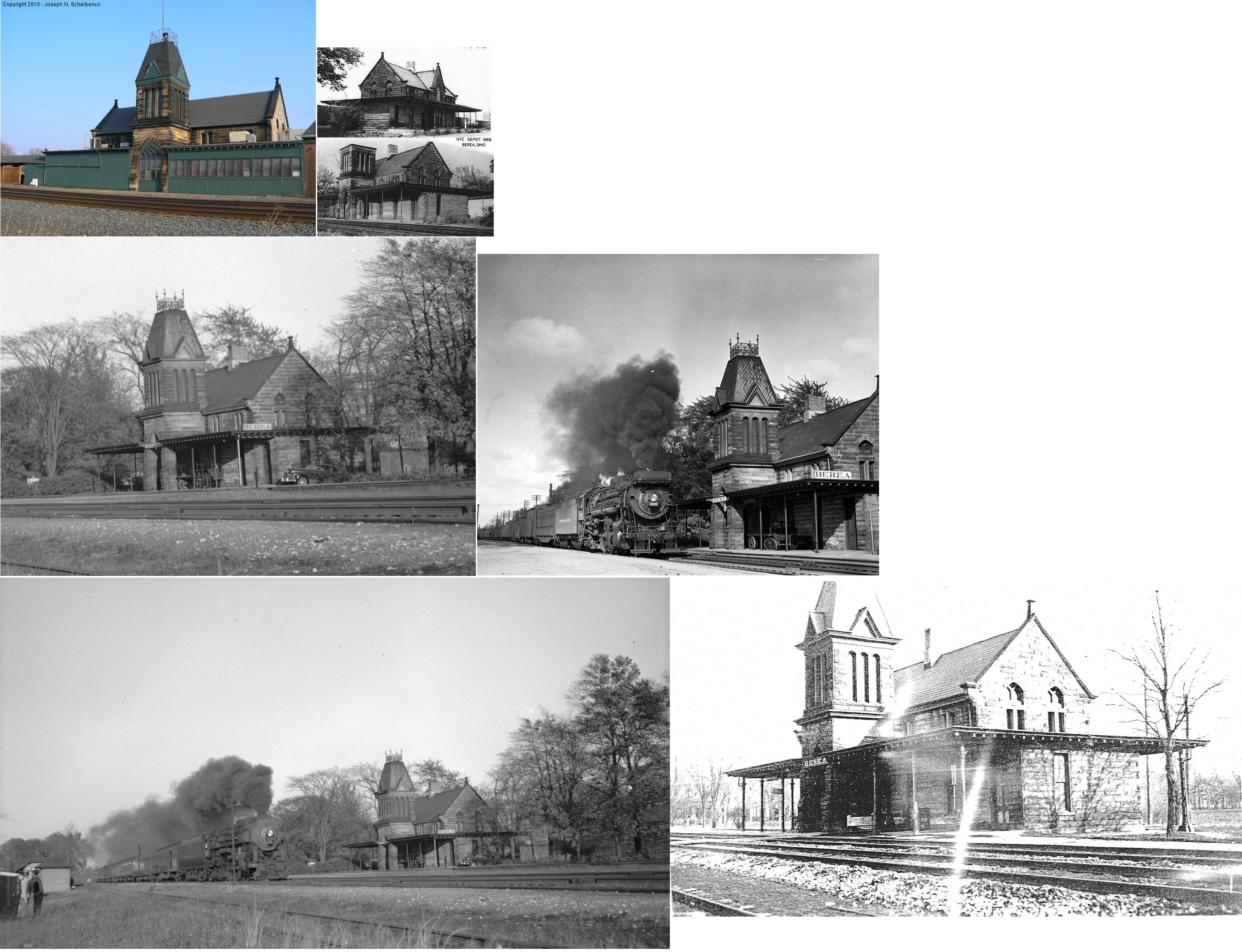
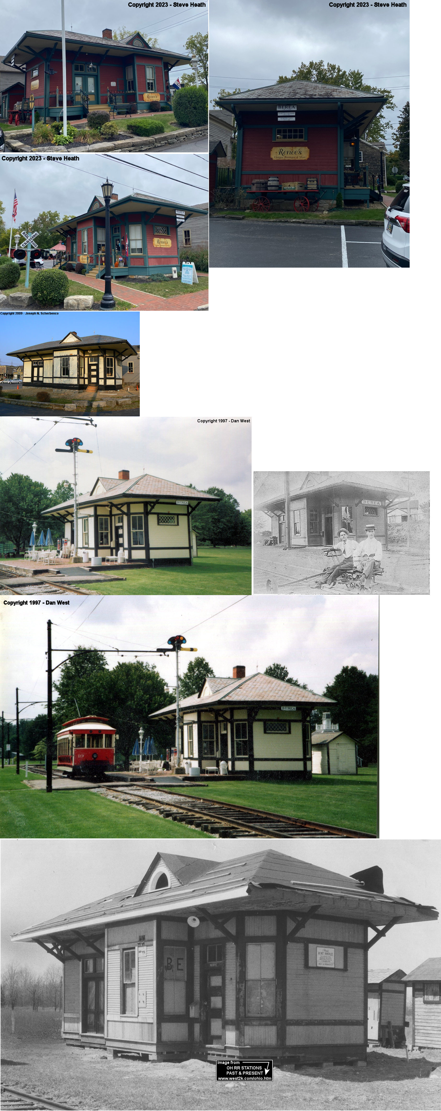
| Berea |
 |
30 Depot Street (GPS: 41.380979, -81.854511) |
P | Business | 1876 | In Use | Brick |
|
| Berea |
 |
25596 Mill St, Olmsted Falls (GPS: 41.374324, -81.902659) |
C | Museum | 1899/ 1912 |
None | Wood |
|
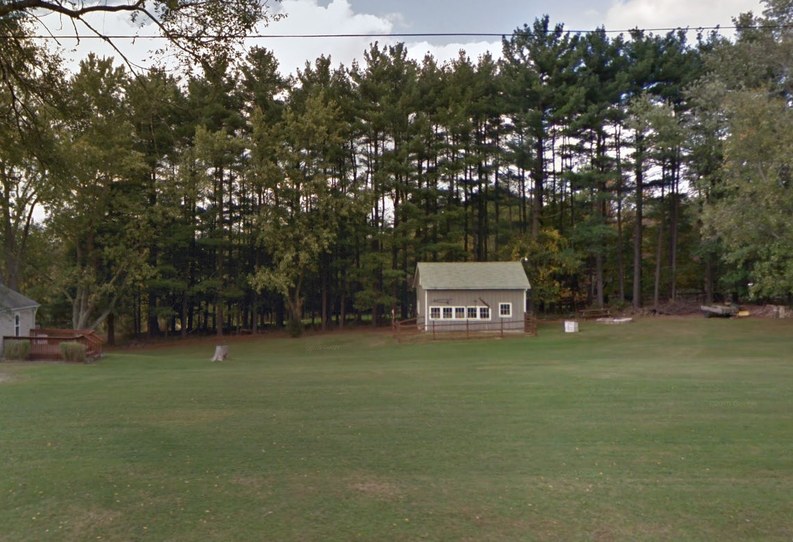
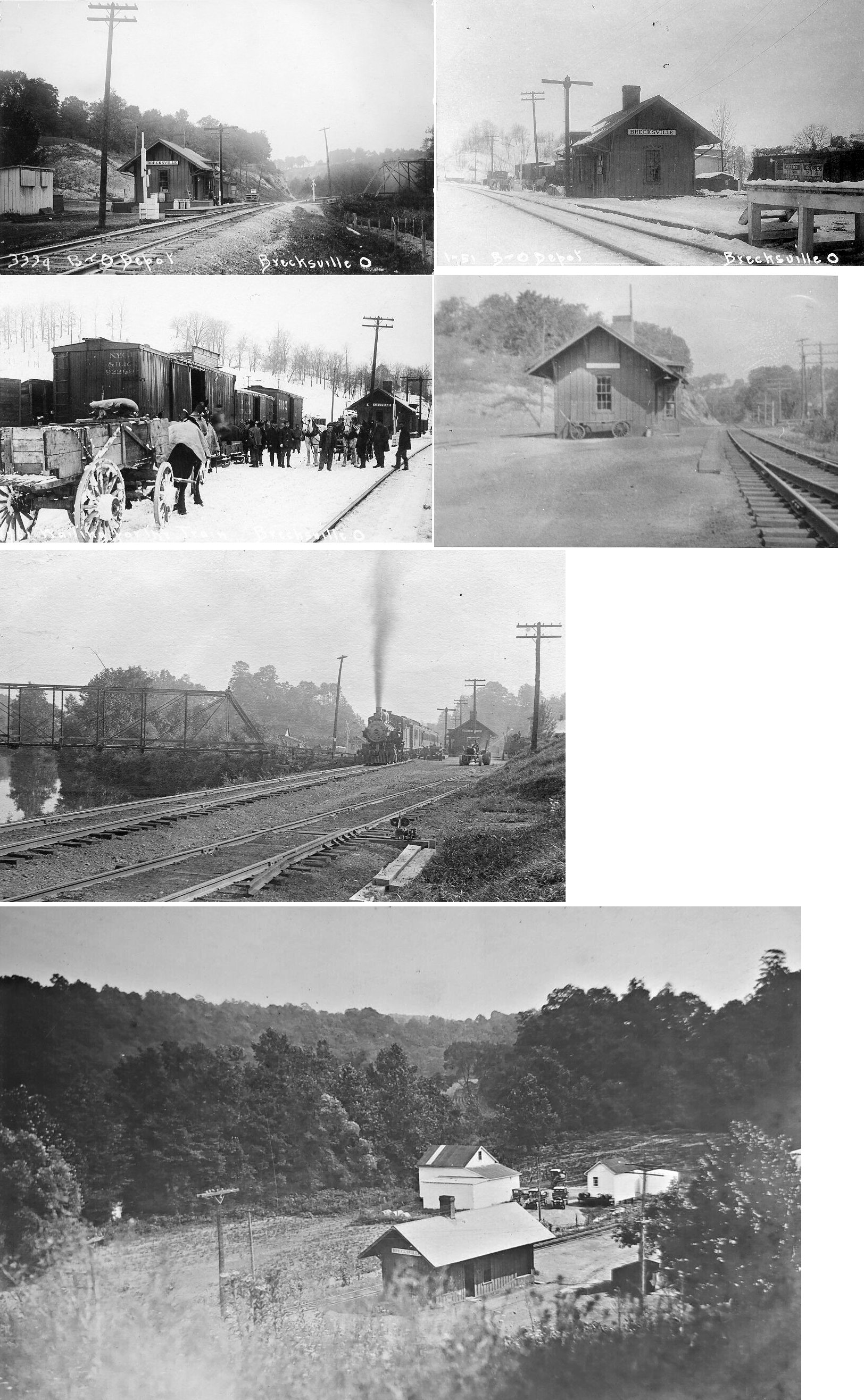
| Brecksville |
 |
721 West Highland Road, Sagamore Hills, Summit County (GPS: 41.292241, -81.547908) |
F | Barn | ???? | None | Wood |
|
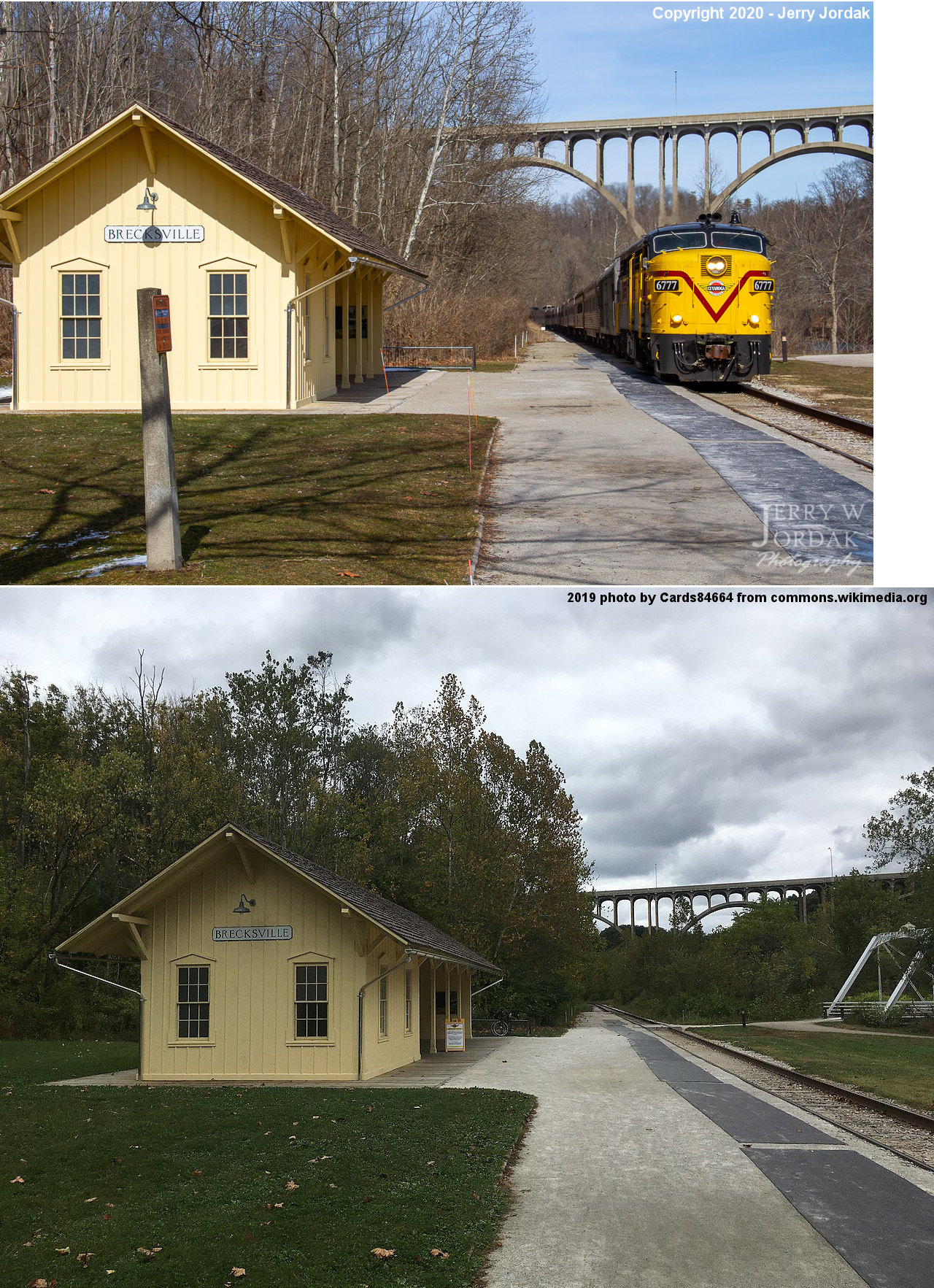
| Brecksville |
 |
13512 Station Road (GPS: 41.319000, -81.588100) |
P | Railroad | ???? | In Use | Wood | |
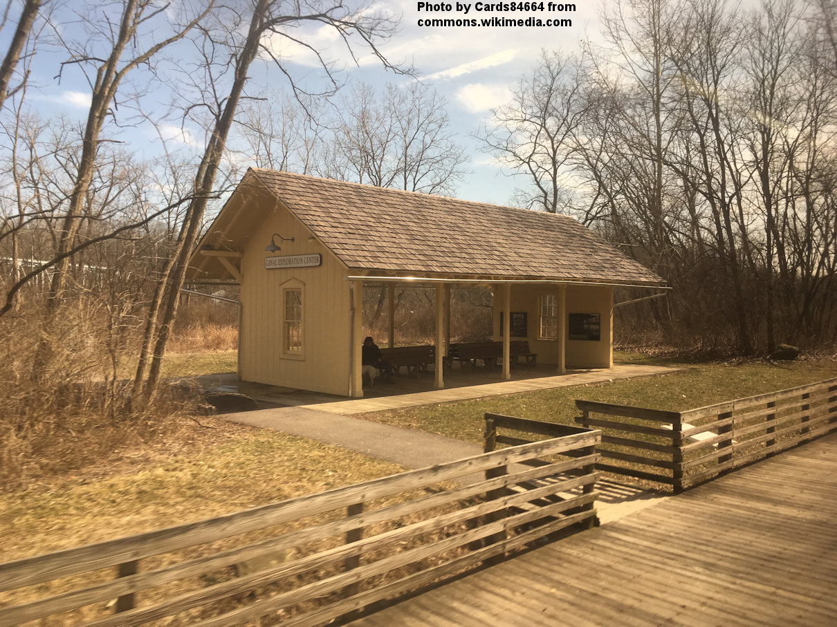
| Canal Exploration Center Sta. |
|
7104 Canal Road, Valley View (GPS: 41.3732, -81.6162) |
P | Railroad | ???? | In Use | Wood | |
| Chagrin
Falls |
 |
Geauga County Fairgrounds | F | Business | 1870 | Gone | Wood |
|
| Cleveland |
 |
Public Square (GPS: 41.498371, -81.693912) |
P | Offices/Mall | 1927 | In Use | Brick |
|
| Cleveland |
|
829 Canal Road in the Flats (GPS: 41.495495, -81.698608) |
P | Vacant | 1898 | Gone | Brick |
|
| Cleveland |
 |
2769 Commercial Road (GPS: 41.490858, -81.686020) |
F | Warehouse | ???? | ???? | ???? |
|
| Cleveland |
 |
200 East Memorial Shoreway (GPS: 41.499495,-81.695409) |
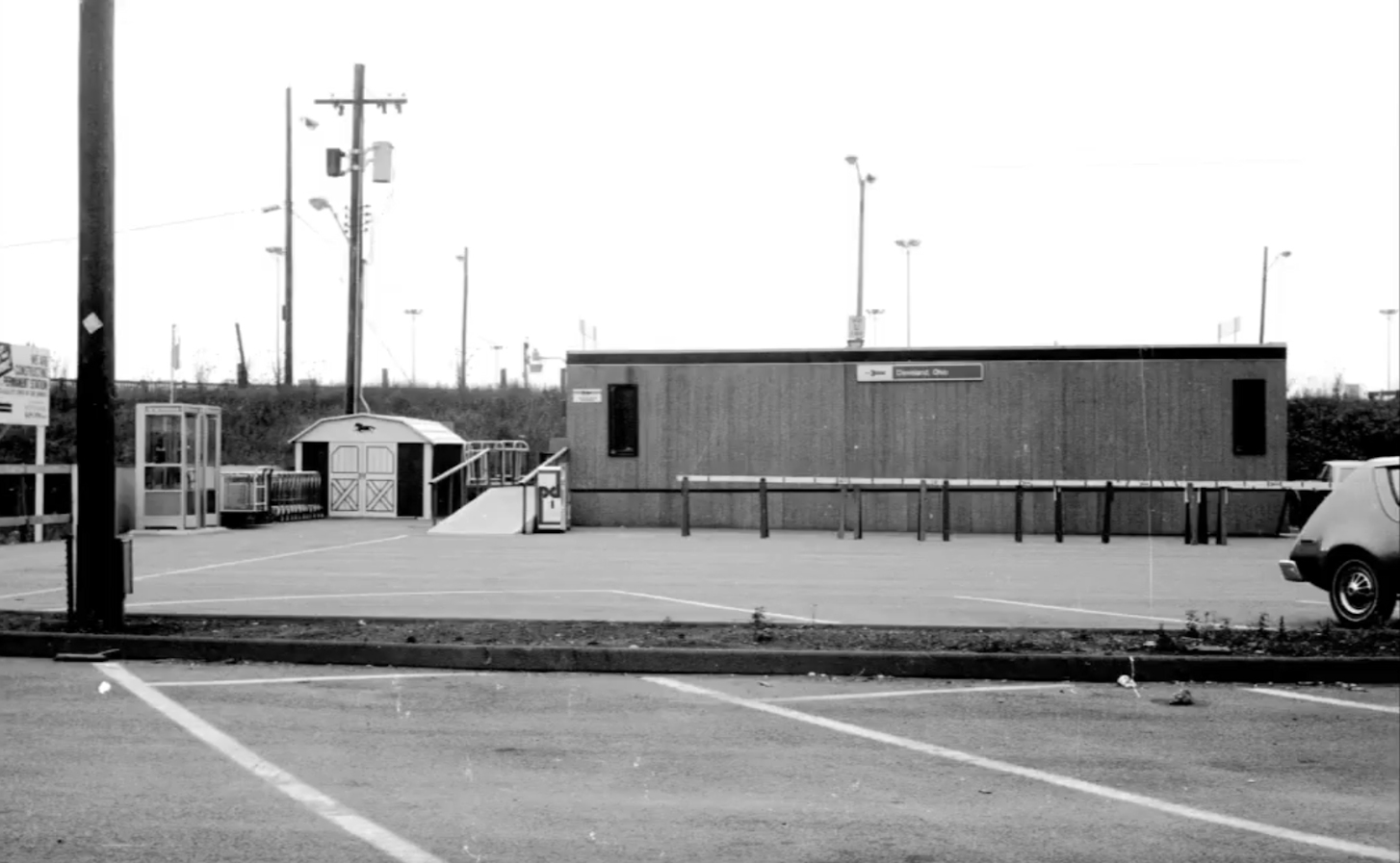
P | Railroad | 1977 | In Use | Brick | |
| CLEVELAND (Glenville) |
 |
9920 Foster Avenue, Bratenahl. South side of Foster Avenue east of Garfield Lane (5th house from the corner). | C | Residence | ???? | None | Wood |
|
| Falls Junction |
|
Pettibone Road, Glenwillow (GPS: 41.356648, -81.466618) |
P | Society | 1905 | In Use | Wood |
|
| Falls Junction |
|
Pettibone Road adjacent to older Connotton Valley depot. (GPS: 41.356507, -81.466534) | F | Railroad | ???? | In Use | Metal | |
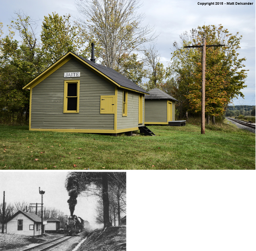
| Jaite (Vaughn's Siding) |
|
North side of Vaughn Road near Riverview Road (GPS: 41.288788, -81.572927) |
P | Park | ???? | In Use | Wood | |
| Olmsted Falls |
|
25802 Garfield Road (GPS: 41.375039, -81.905949) |
C | Civic | 1876 | In Use | Wood |
|
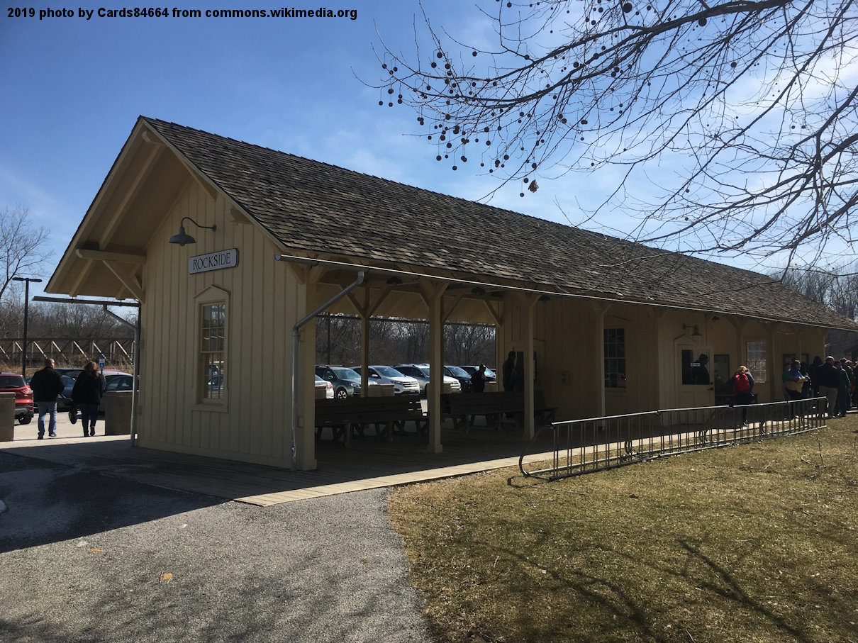
| Rockside Road |
|
7900 Old Rockside Road, Independence | P | Railroad | ???? | In Use | Wood | |
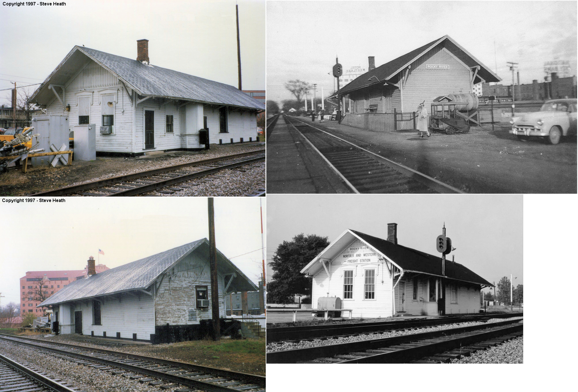
| Rocky River |
|
19060 Depot Street (GPS: 41.483867, -81.834701) |
P | Railroad | 1882 | In Use | Wood | |
|
Shaker
Heights (Lee Road) |
 |
West side of Lee Road south of Miles Avenue (GPS: 41.439485,-81.566057). | P | Vacant | 1948 | In Use | Brick | |
| Solon |
 |
33200 Bainbridge Road (GPS: 41.390047, -81.443830) |
P | Business | 1882 | Aband. | Wood |
|
| STATIONS OF THE PAST | ||||||||
| Station Name |
Original Railroad |
Notes | ||||||
| Alexanders |
 |
The 1905 and 1922 timetables shows a stop at Alexanders. This station was on Fitzwater Road in the vicinity of GPS: 41.354597, -81.600680. | ||||||
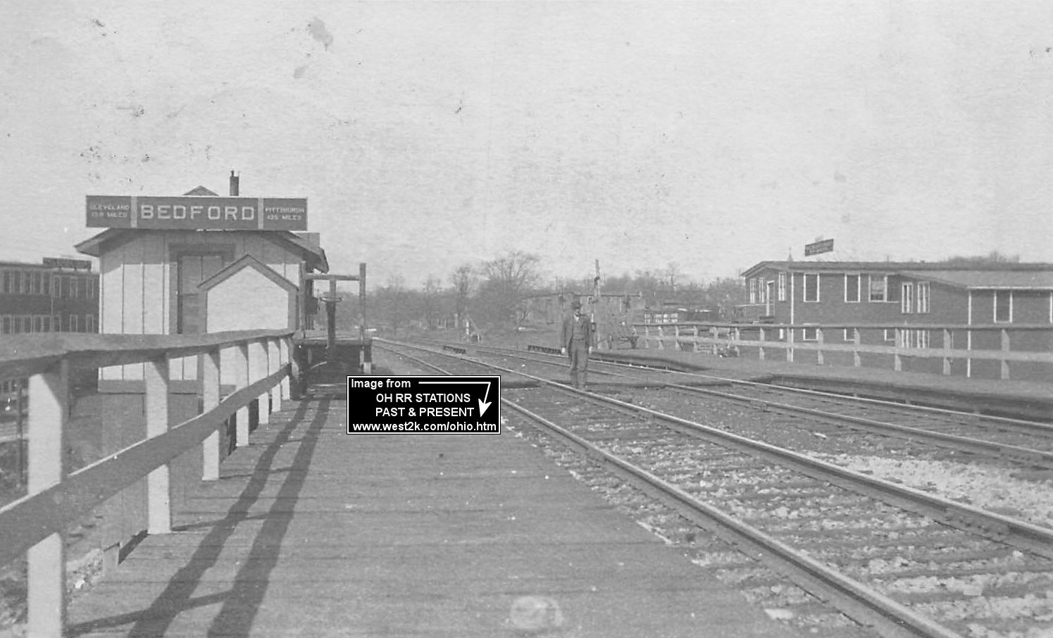
| Bedford |
 |
The original combination station was just to the west of the existing Connotton Valley (W&LE) station at the corner of North Park and Willis Streets (GPS: 41.390148, -81.535661). A station is shown on maps as early as 1874. | ||||||
| Bedford |
|
When the mainline was rebuilt between Cleveland and Ravenna in the early 1900s, a new station and passenger shelter was built in 1903 on the new alignment. This raised station was on the west side of the tracks at the underpass for Bedford Glens Road at GPS: 41.389697, -81.537107. | ||||||
| Bedford |
|
According to the 1917 PRR valuation records, a freight station was built here in 1894. According to the Sanborn Insurance map of 1902 this station was next to the original passenger station on the original alignment through town (which ran down the middle of Willis Street). A W&LE property map from 1929 shows the C&P freight station on the east side of Willis Street between North and South Park Streets at GPS: 41.390082, -81.535682. | ||||||
| Berea |
|
There was a freight station across the tracks from the passenger station. This may have been the original frame station here. It was standing until at least the late 1940s or later. | ||||||
| BEREA |
 |
NYCRR valuation records list a 12'x8' passenger shelter here on the old LS&MS line built in 1917. This may have just been a waiting shelter across the tracks from the main station rather than a stand alone shelter. | ||||||
|
Brecksville (Chaffee) |
|
|||||||
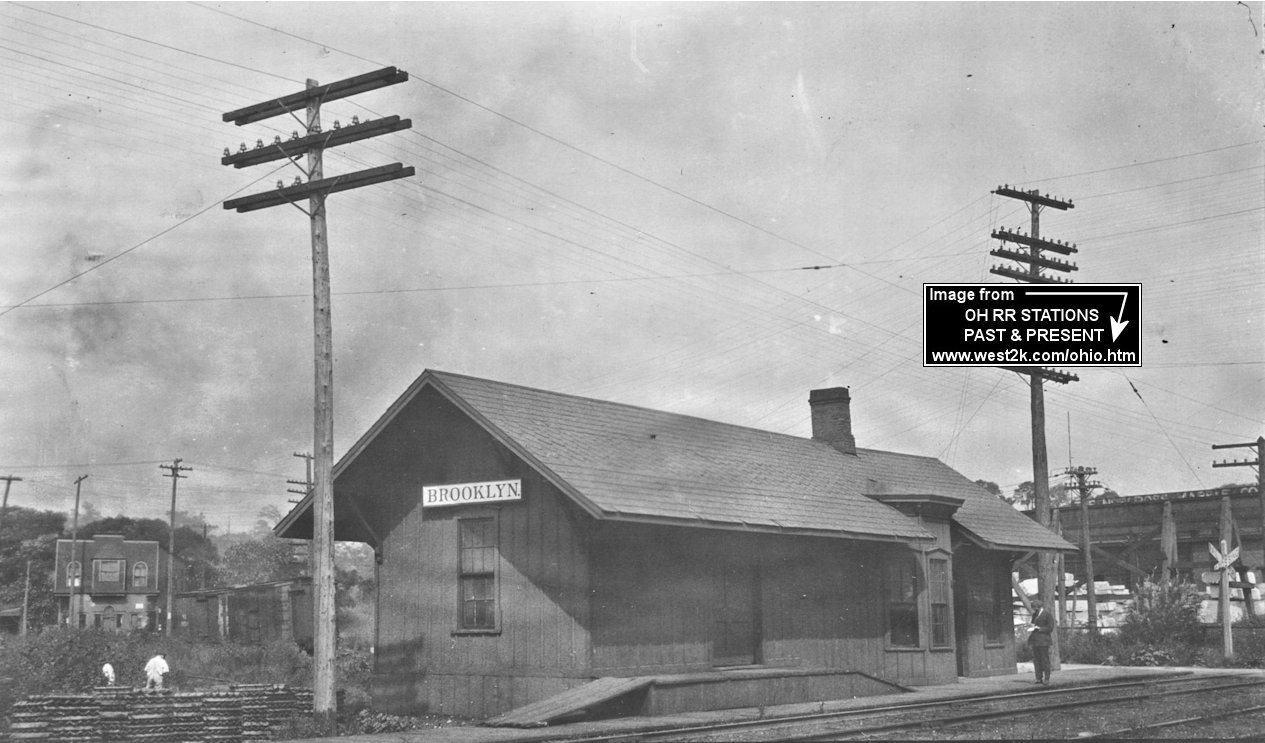
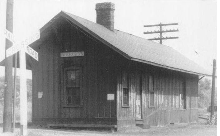
| Brooklyn |
|
The Brooklyn B&O station was on the south side of Harvard Avenue just east of Jennings Road. It was on the west side of the tracks at GPS: 41.447323, -81.686714. The Norcross Marble Works can be seen in the background right of the photo. | ||||||
| Brooklyn (S. Brooklyn) |
 |
This first generation station was on the west side of Pearl Road just north of the former location of Brookside Park Drive at GPS: 41.445341, -81.703380. The station was on the south side of the tracks and sat between the trestle and where the Pearl Road overpass is today. | ||||||
| Brooklyn (S. Brooklyn) |
|
This station replaced the one listed above at the same location. | ||||||
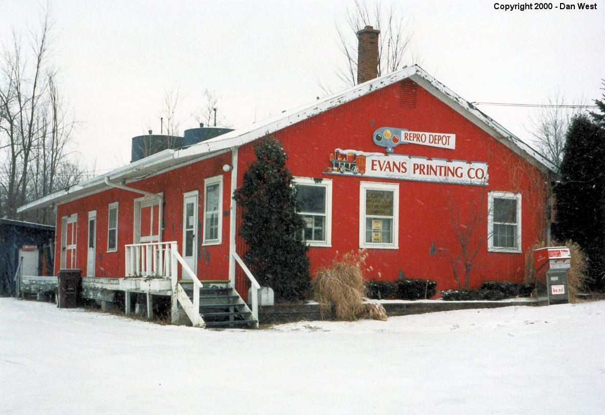
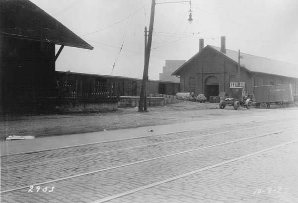
| Chagrin Falls |
 |
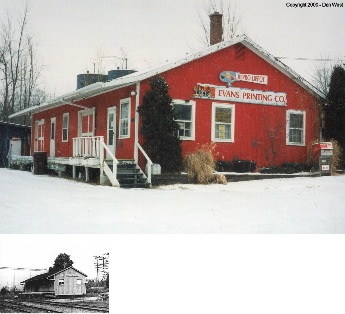
This station was at 165 East Washington Street. It was torn down around 2010-11 after housing a printing business for several years prior. | ||||||
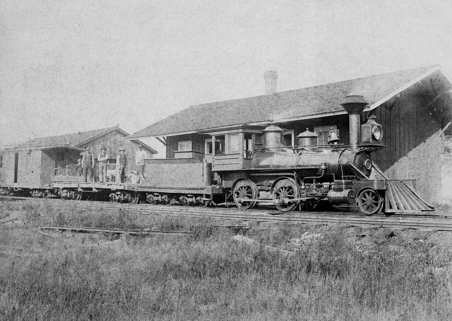
| Chagrin Falls |
|
This station was built in 1880. This passenger station was located at the end of the line between East Washington and Bell Streets at approximately GPS: 41.430373, -81.385741. There was a separate freight station behind the passenger depot which can be seen in the photo. | ||||||
| Chagrin Falls |
|
The photo shows the passenger and freight stations. The freight station is still standing (see listing above in the section of existing stations). | ||||||
| Chamberlains |
|
This flag stop was on Liberty Road in the vicinity of GPS: 41.391286, -81.418692. It is listed on an old CC&S timetable and appears to be named after property owner Leander Chamberlain. | ||||||
| Note: For the cleveland stations below, the more obscure predecessor railroads are listed with their more commonly known "modern" names (in parentheses) after mergers and acquisitions. | ||||||||
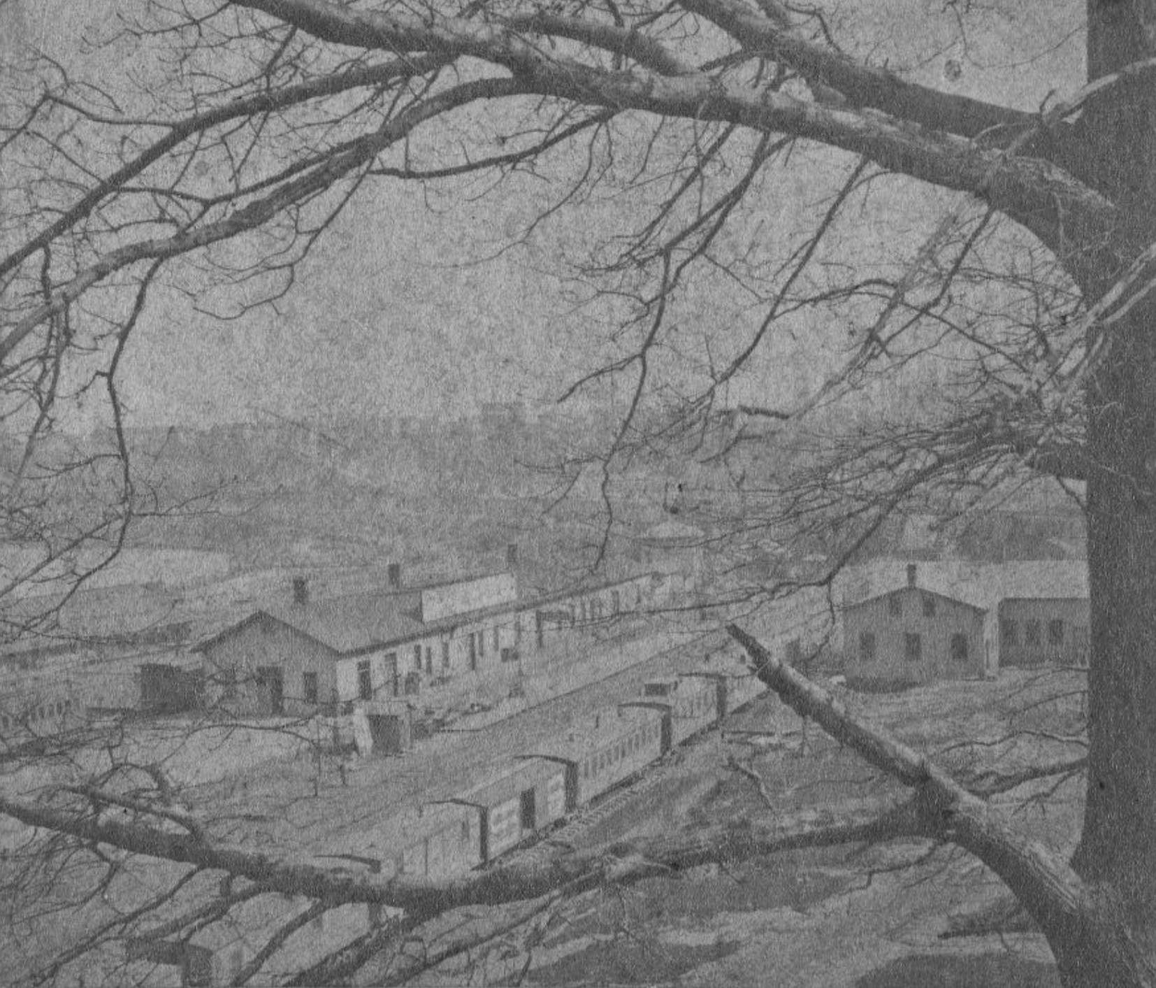
| Cleveland |
|
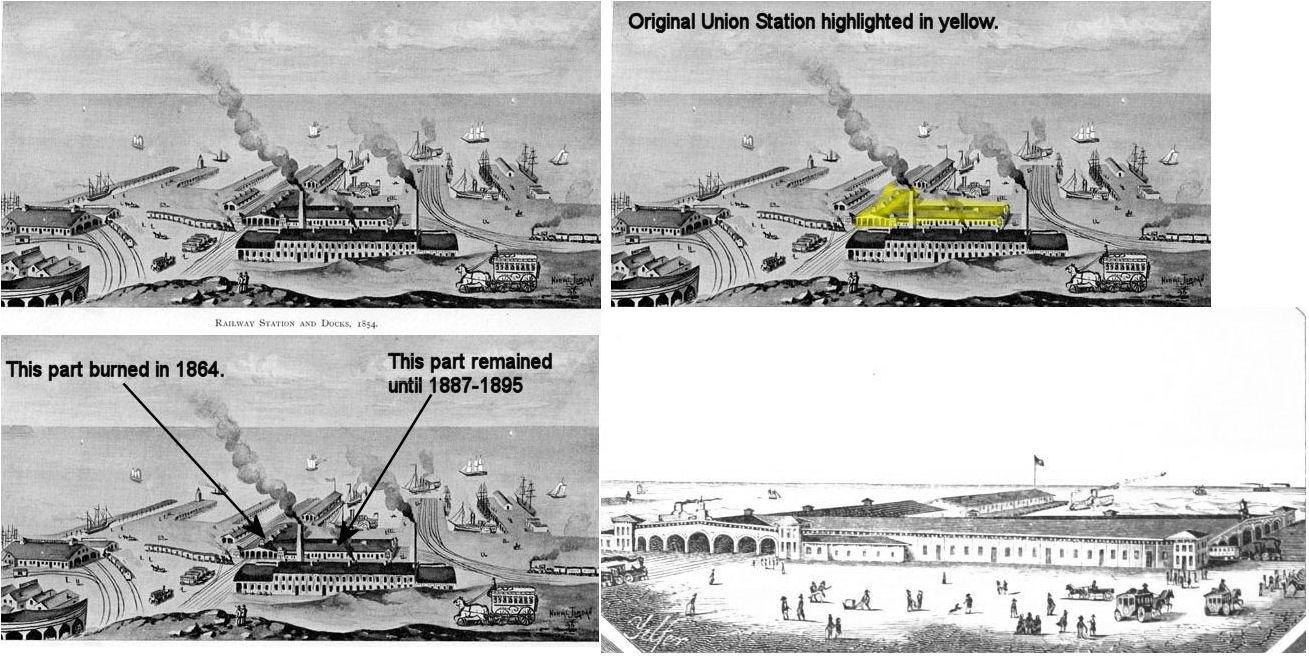
The first Union Station was built between 1851-53 and sat along the lake at the northern end of what is now West 9th Street (Case Western Reserve University). It was a large brick structure with a collection of wooden sheds and it supposedly partially burned in 1864, although the map from 1874 shows the station at the location with the label "Old Depot." The remaining half of the building survived until sometime between 1887-1895. It was located north of, and between, the 1866 Union Station and Union Freight Depot. On the 1886 map, the reamaing part of this large building is identified as "LS&C and PRR's old passenger depot. Used for housing, cleaning and repairing cars." This station was due north of the intersection of West 10th Street (formerly Spring Street) and Front Avenue on the north side of the tracks. The remaining part of the original station is not pictured on the 1895 Sanborn map after having been demolished. | ||||||
| Cleveland |
|
This was the second Union station in Cleveland, built in 1866 after the original Union Station burned in 1864. It opened for passenger service in November of 1866. It sat between W. 6th Street (Bank St.) and W. 9th Street (formerly Water St.) at the lakeshore. It lost most of its traffic when Terminal Tower opened in 1930. Throughout it's lifetime the station served the predacessor lines of the CCC&StL, LS&MS, PRR. It served the PRR after that until 1953 and was demolished in 1959. | ||||||
| Cleveland |
 (BIG 4) |
Maps from 1874 show a passenger station at Columbus Avenue and Merwin Road in the Flats. There was also a large freight house to the northwest along Merwin. | ||||||
| Cleveland |
(BIG 4) |
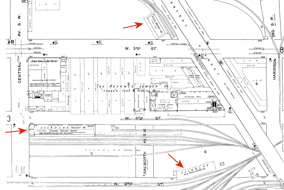
There was a freight station on the south corner of what was Scowden and Ohio Streets. These streets are now gone, but the modern location is GPS: 41.490573, -81.689434 below the Innerbelt Freeway bridge. This station was later known as the CCC&St.L Central Freight Depot. There was also a freight house nearby for oil and paints at GPS: 41.489669, -81.689541. | ||||||
| Cleveland |
(BIG 4) |
There was an old station on Vineyard Street (later renamed Water Street). When Lincoln's funeral train went from Cleveland to Columbus, the train left from this station after traveling to Cleveland over the C&P Railroad. | ||||||
| Cleveland |
(BIG 4) |
Some old timetables list a station stop at Clark Avenue. Sanborn Insurance maps don't show that station, but the 1903 Rand McNally map of Cleveland shows it on the corner of Clark Avenue and Alum Street. The station appear on 1888 timetables, but was gone sometime after 1910, but before 1914. | ||||||
| Cleveland |
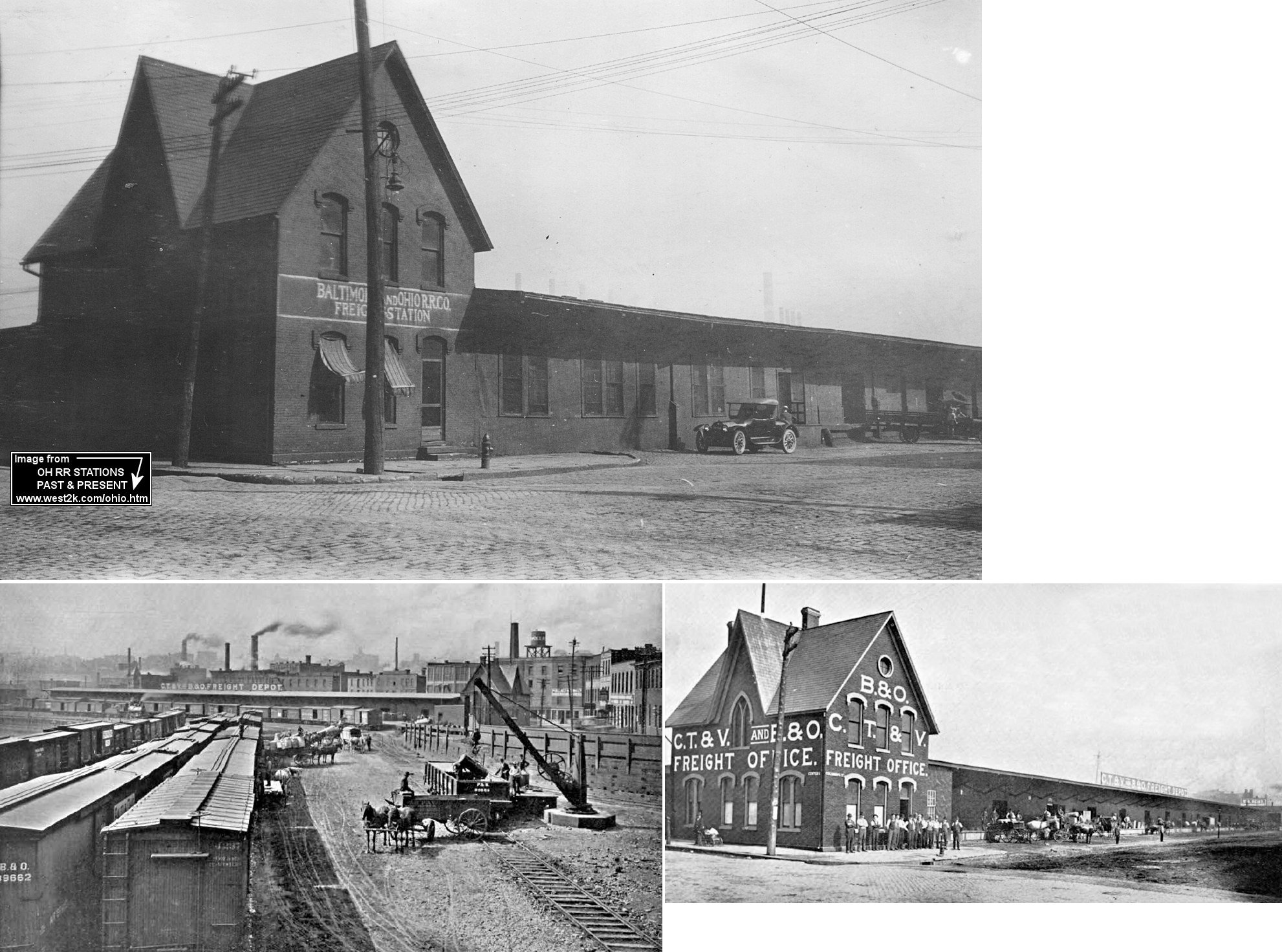
(B&O) |
Before the 1898 CT&V station was built at 829 Canal Road in the Flats, there was an earlier station at this same loaction built in 1880 by the Valley Railway. This station is referred to as the Seneca Street station. | ||||||
| Cleveland |
(B&O) |
There was a freight station on the east side of Merwin Street near what is now West Avenue. The station was across the tracks from the old Hughes Brewery (acording to the 1886 map). This station was about a half block WSW of the Valley passenger station. This area is now a parking lot on the north side of West Avenue. | ||||||
|
Cleveland (Broadway) |
(B&O) |
The Valley Railway had a Broadway station that was near where Rockefeller Avenue is today just south of Broadway. It was in the vicinity of GPS: 41.483715, -81.673982. This station is shown on the 1905 timetable. | ||||||
|
Cleveland (Clark Ave.) |
(B&O) |
The 1922 timetable shows a stop at Clark Avenue. This station was near the intersection of Clark Avenue and Quigley Road in the vicinity of GPS: 41.470094, -81.681645. It is unclear if there was an actual station here or just a flag stop. | ||||||
|
Cleveland (Thornburgh) |
(B&O) |
The 1922 timetable shows a stop at Thornburgh. This station was likely on Old Rockside Road in the vicinity of GPS: 41.394644, -81.631332. | ||||||
|
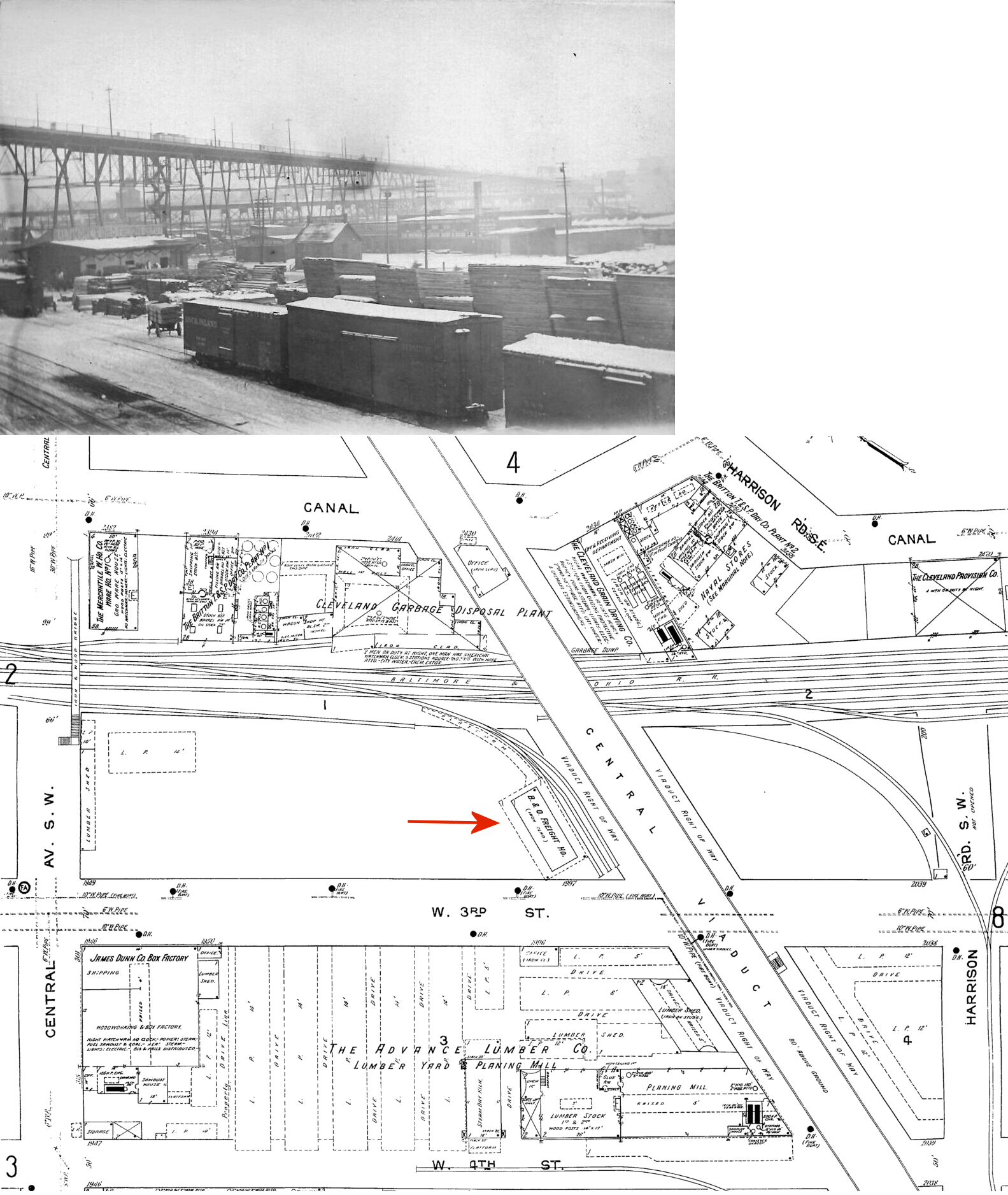
Cleveland (Seneca Street) |
(B&O) |
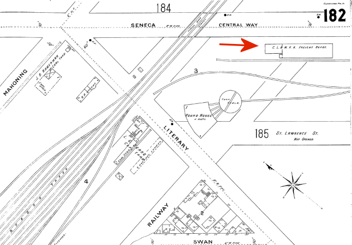
There was a freight house along the west side of West 3rd Street (formerly Seneca Street, formerly Central Way), about 300-400 feet south of the intersection with Literary Road and Mahoning Avenue at around GPS: 41.484844, -81.682488. The freight house served a spur that ran parallel to 3rd Street and not the tracks that crossed 3rd just to the north of the station. There was a CL&W turntable and roundhouse about 100 feet due west of the depot. | ||||||
| Cleveland (Columbus Road) |
AND |
This 500-foot freight station was on the east side of Columbus Road at Center Street stretching to the south. It was built in 1896 and could accommodate 85 freight cars at once. | ||||||
| Cleveland (Columbus Road) |
|
Built in 1954, this freight station replaced the one listed above. It was used for less-than-carload freight, mainly produce. It sat idle for 15-20 years before being torn down in 2001. It was located on the east side of Columbus Road and stretched from near West Street (GPS: 41.494215, -81.699626) down to near Leonard Street (GPS: 41.492354, -81.700298). | ||||||
|
Cleveland (NewBurgh) |
|
There was a freight station at 8222 Broadway Avenue (on the southwest side of the street) at GPS: 41.450290, -81.630145. This station is shown on maps from the 1950s. | ||||||
|
Cleveland (NewburgH) |
|
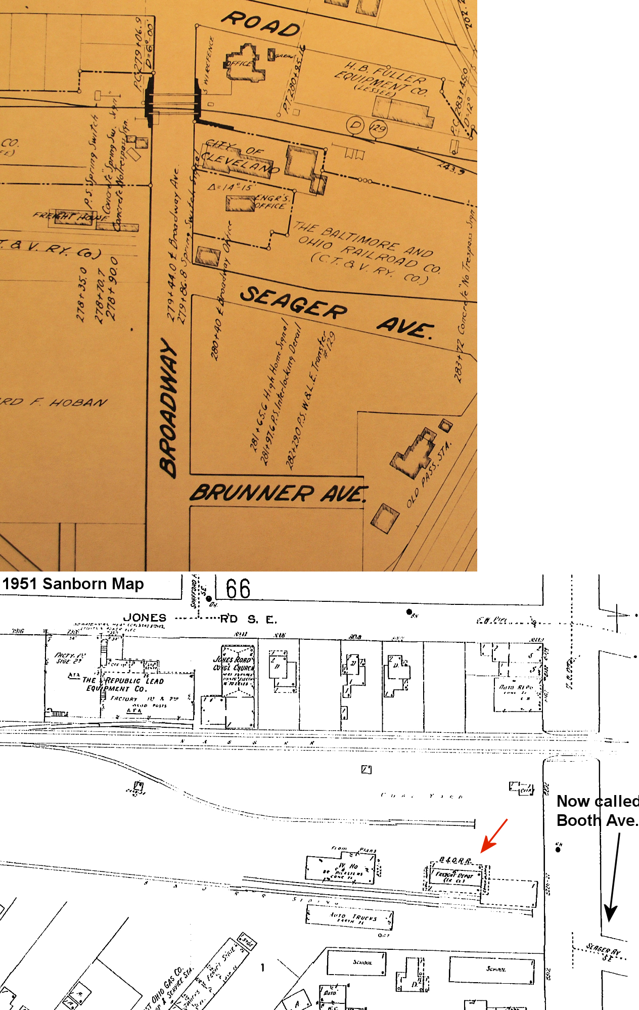
Prior to the station listed above, there was a freight station on the NE side of Broadway at the end of Seager Avenue S.E. (now called Booth Avenue) at GPS: 41.450967, -81.628457. The siding tracks here were parallel to Booth Avenue. There was also a hotel at the end of this street called the Washington House. This station and hotel were both due north of the old C&P passenger station which was at the end of Brunner Street. It appears on maps as early as 1886. | ||||||
| Cleveland (Brooklyn) |
|
There were small freight stations in both Brooklyn and South Brooklyn. The one in South Brooklyn was at 4002 West 25th Street. | ||||||
| Cleveland |
|
There was a freight station on the NE side of West 3rd Street near where the I-90 bridge crosses overhead today at GPS: 41.490607, -81.688026. It was on a short spur there. The area is now (2010) a large parking lot. The station is shown on the 1912 Sanborn map, but was gone by the revised maps of the 1950s. | ||||||
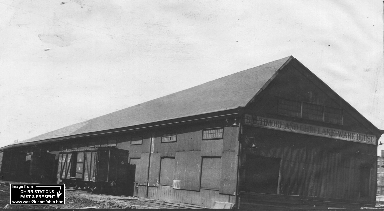
| Cleveland |
|
The B&O Lake Warehouse was on the Cuyahoga River just east the Shoreway bridge at the north end of Main Avenue at GPS: 41.497735, -81.704745. It was built in 1898 and primarily handled package freight being shipped to or received from northern lake ports. | ||||||
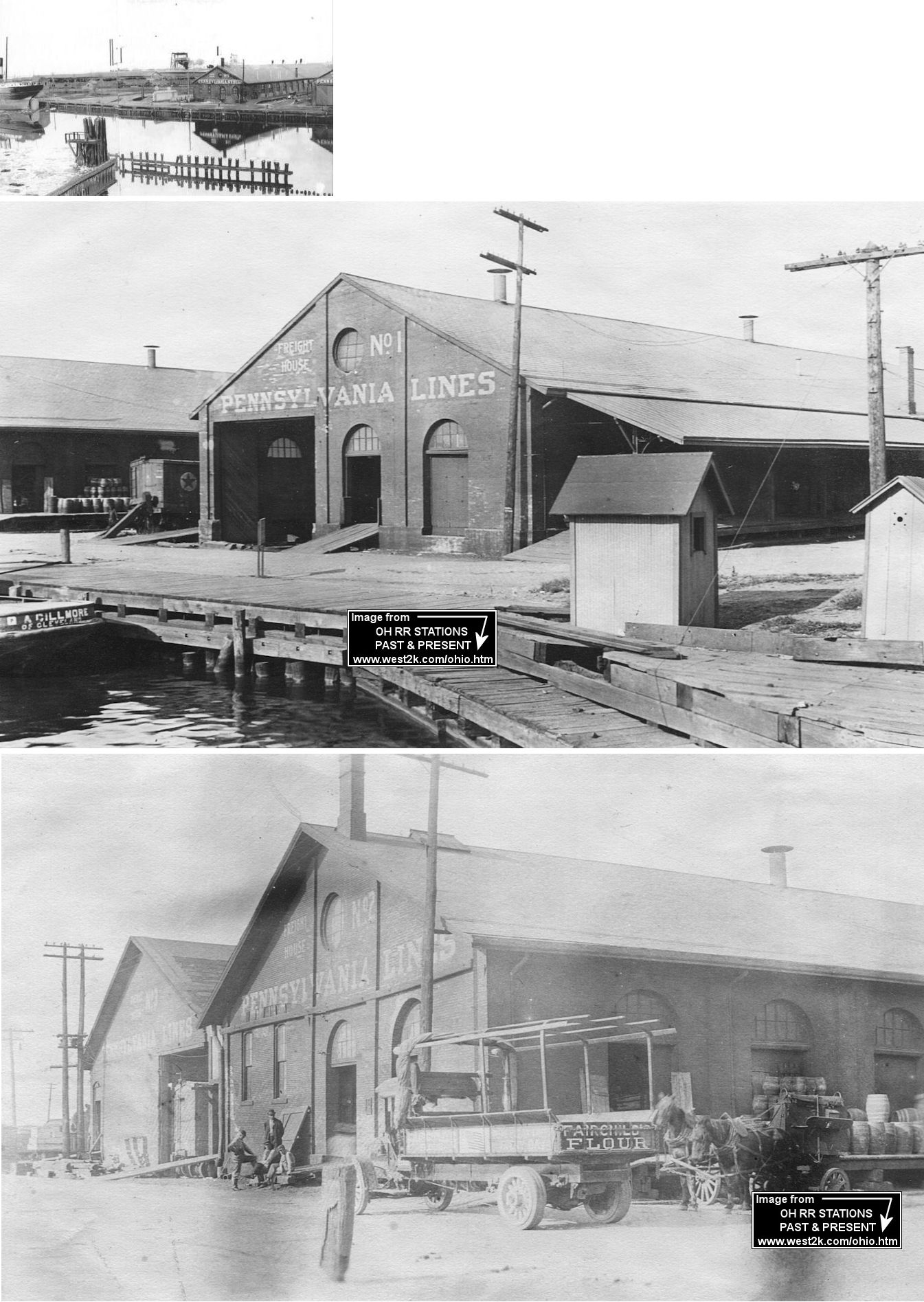
| Cleveland |
(W&LE) |
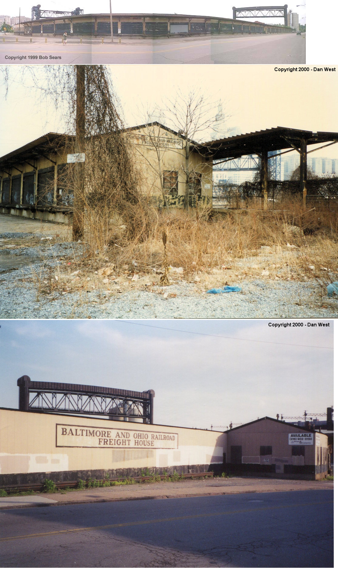
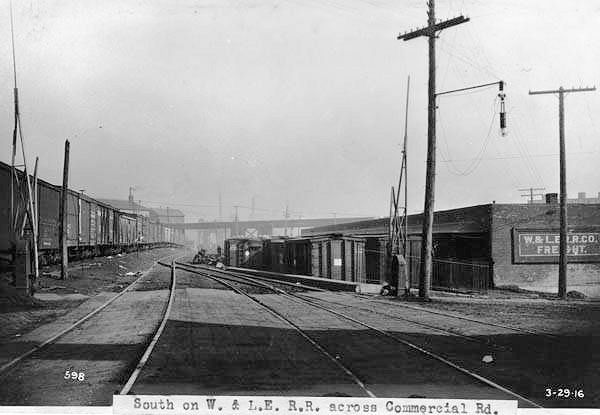
The first CV passenger station was opened in 1881 on Commerical Road. Later this building was used as a freight station. According to the 1886 Sanborn maps, there was a small CV station, office, and platform on the east side of Commmercial Road just north of Canal Street. This station would be torn down by the CC&S in the early 1890s and replaced with a brick freight house. A freight house was also added across the street on the west side of Commercial Road (this one is still standing). | ||||||
| Cleveland |
(W&LE) |
This freight station replaced the original one listed above on the east side of Commercial Road. | ||||||
|
Cleveland (Newburg) |
(W&LE) |
There was a passenger station at the NE end of Jones Road (formerly Jones Street) east of Broadway Avenue at GPS: 41.451715, -81.629518. The station was on the north side of the street and the west side of the tracks. This station appears on the 1886 and 1903 maps of the area. | ||||||
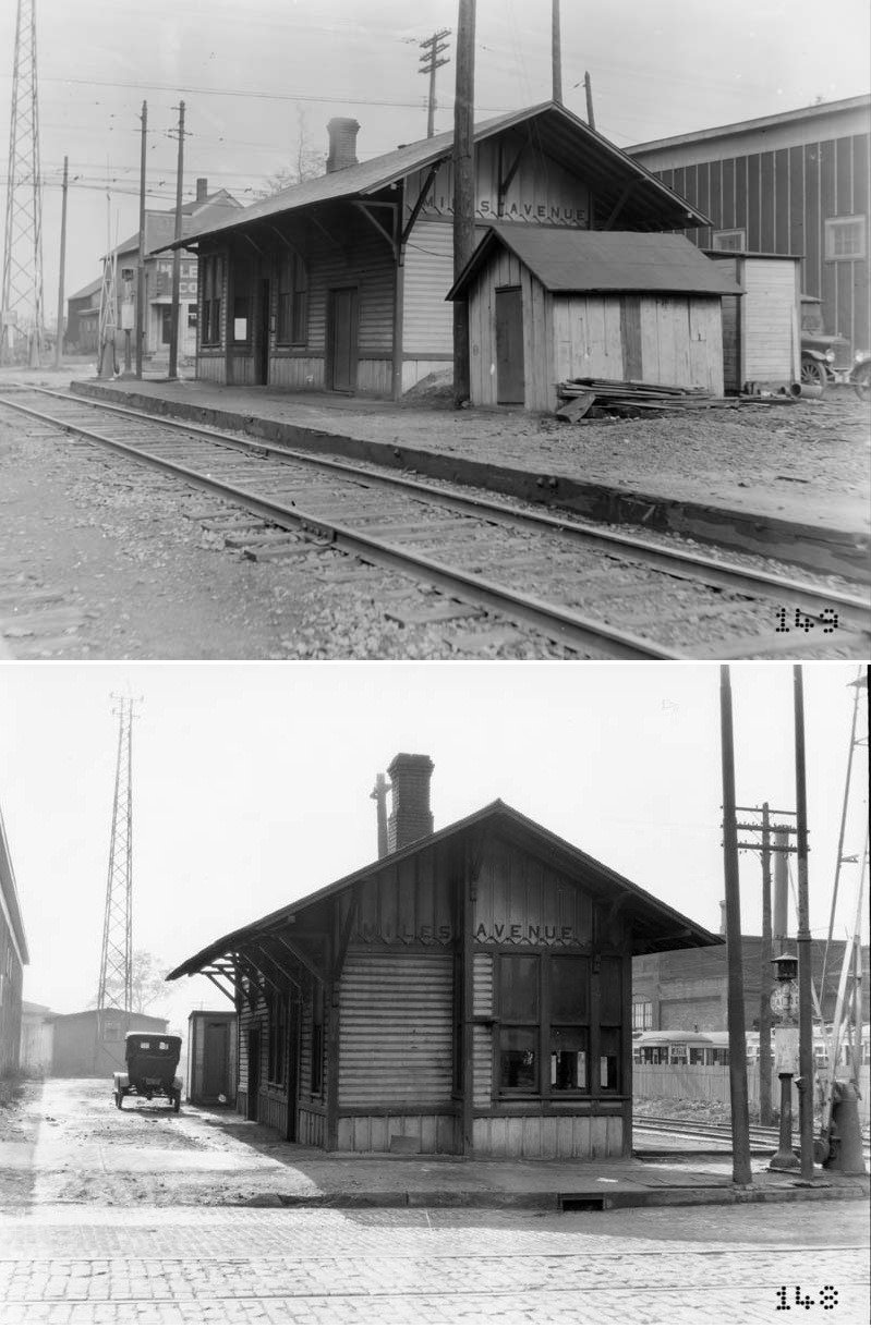
| Cleveland (Miles Avenue) |
(W&LE) |
There was a station on the south side of Miles Avenue east of 102nd Street on the east side of the tracks at GPS: 41.445035, -81.613363. | ||||||
| Cleveland (Henry Street) |
(W&LE) |
This pre-W&LE station was on Henry Street when it used to cross the tracks. It may have been a flag stop, but some old maps show a building there. It was in the vicinity of GPS: 41.431671, -81.600390. | ||||||
| Cleveland (Petrie Street) |
(W&LE) |
This pre-W&LE commuter stop was flag-only stop. There was likely never a station building there. It is listed on the CC&S timetable from 1899. It was in the vicinity of GPS: 41.463356, -81.657268. | ||||||
| Cleveland (Axtell Street) |
(W&LE) |
This pre-W&LE commuter stop at Axtell Street (now East 78th Street) was flag-only stop. There was likely never a station building there. It is listed on the CC&S timetable from 1899. It was in the vicinity of GPS: 41.461978, -81.633400. | ||||||
| Cleveland (Woodland Hills) |
(W&LE) |
This pre-W&LE commuter stop was flag-only stop. There was likely never a station building there. It is listed on the CC&S timetable from 1899. It was on East 93rd Street in the vicinity of GPS: 41.451047, -81.621223. The W&LE would build a station here (East 93rd Street Station) in 1909. Not to be confused with the "Woodland" flag stop that was between Bedford and Falls Junction. | ||||||
| Cleveland (McCracken) |
(W&LE) |
This pre-W&LE suburban commuter stop was flag-only stop. There was likely never a station building there. It is listed on the CC&S timetable from 1899. It was on McCracken Road in the vicinity of GPS: 41.424011, -81.584938. | ||||||
| Cleveland (Dunham St.) |
(W&LE) |
This pre-W&LE suburban commuter stop was flag-only stop. There was likely never a station building there. It is listed on the CC&S timetable from 1899. It was on what is now the south end of Greenhurst Extension in the vicinity of GPS: 41.416451, -81.575309. | ||||||
| Cleveland (Oakland Park) |
(W&LE) |
This pre-W&LE suburban commuter stop was flag-only stop. There was likely never a station building there, although a "station" is marked on the 1896 map. It is listed on the CC&S timetable from 1899. It was off what is now Gerard Avenue in the vicinity of GPS: 41.407372, -81.565617. | ||||||
| Cleveland (Independence Rd.) |
(W&LE) |
This pre-W&LE suburban commuter stop was flag-only stop. There was likely never a station building there. It is listed on the CC&S timetable from 1899. It was on what is now Rockside Road in the vicinity of GPS: 41.402271, -81.556310. | ||||||
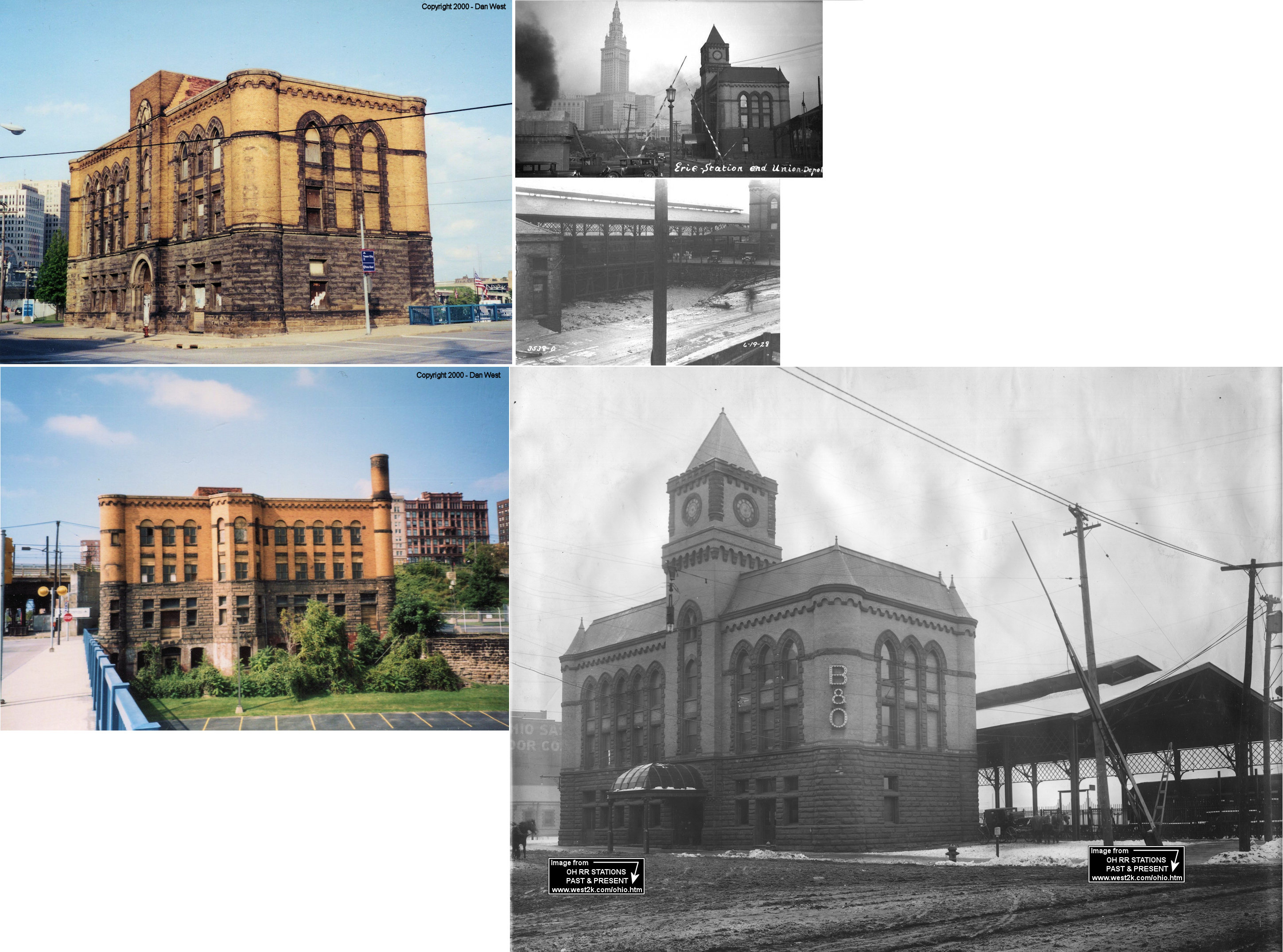
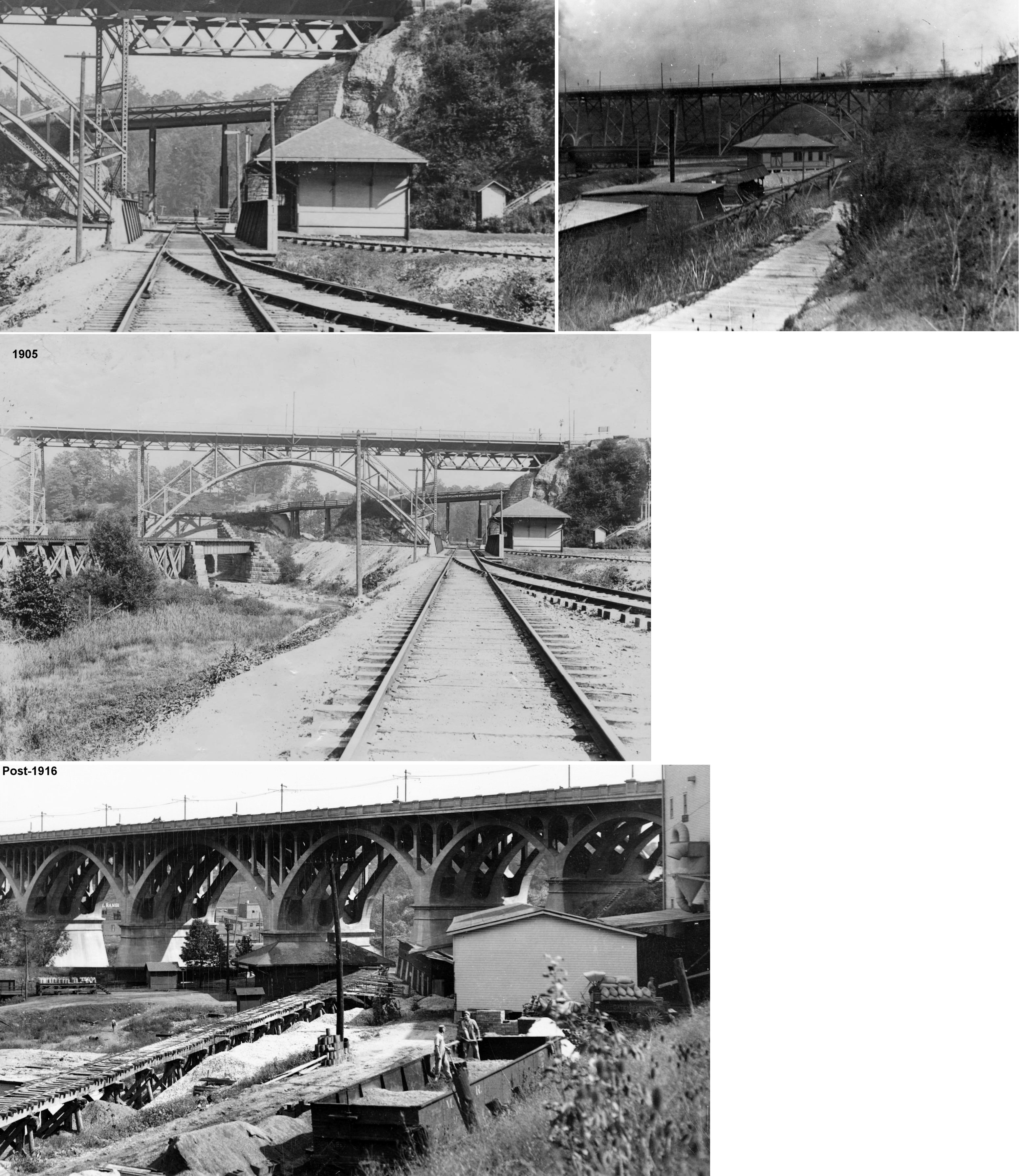
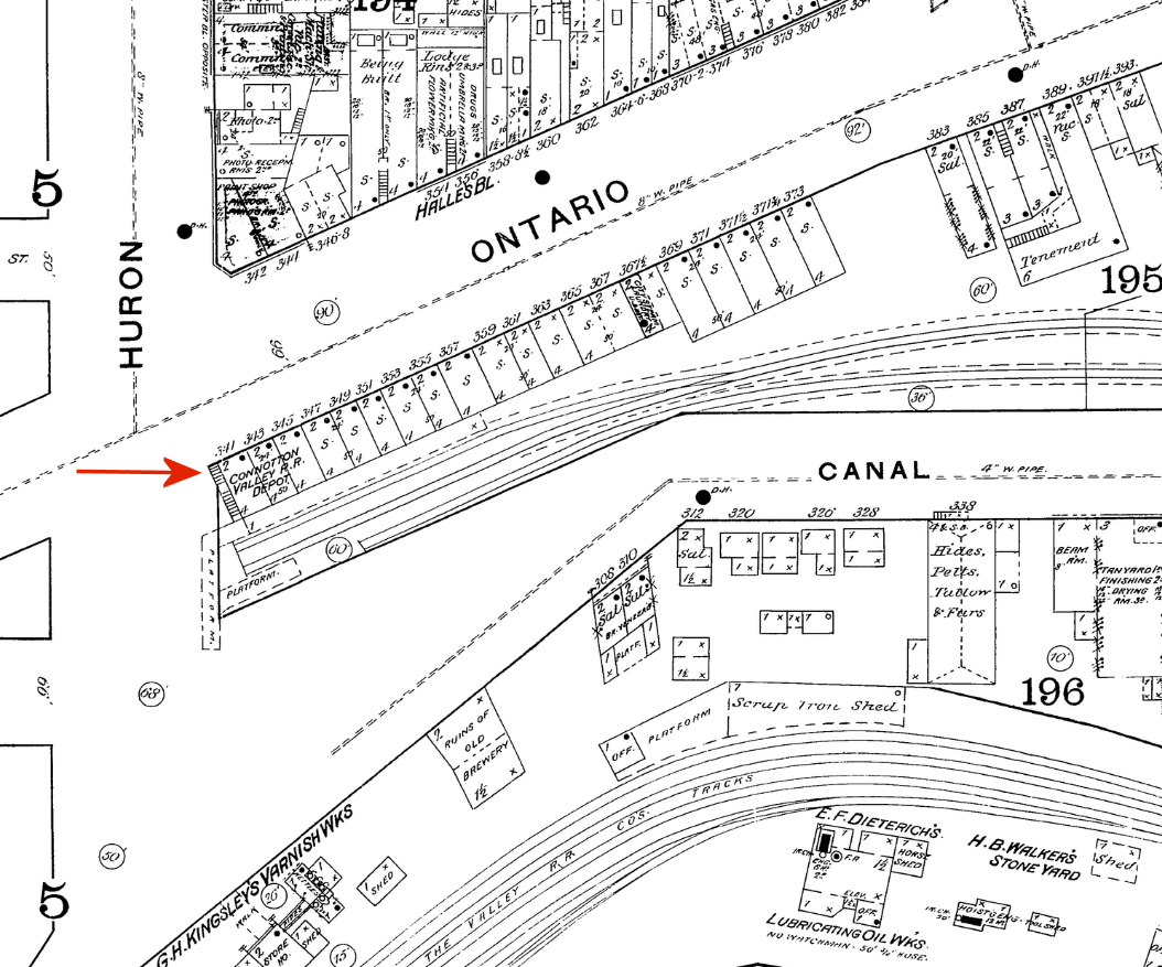
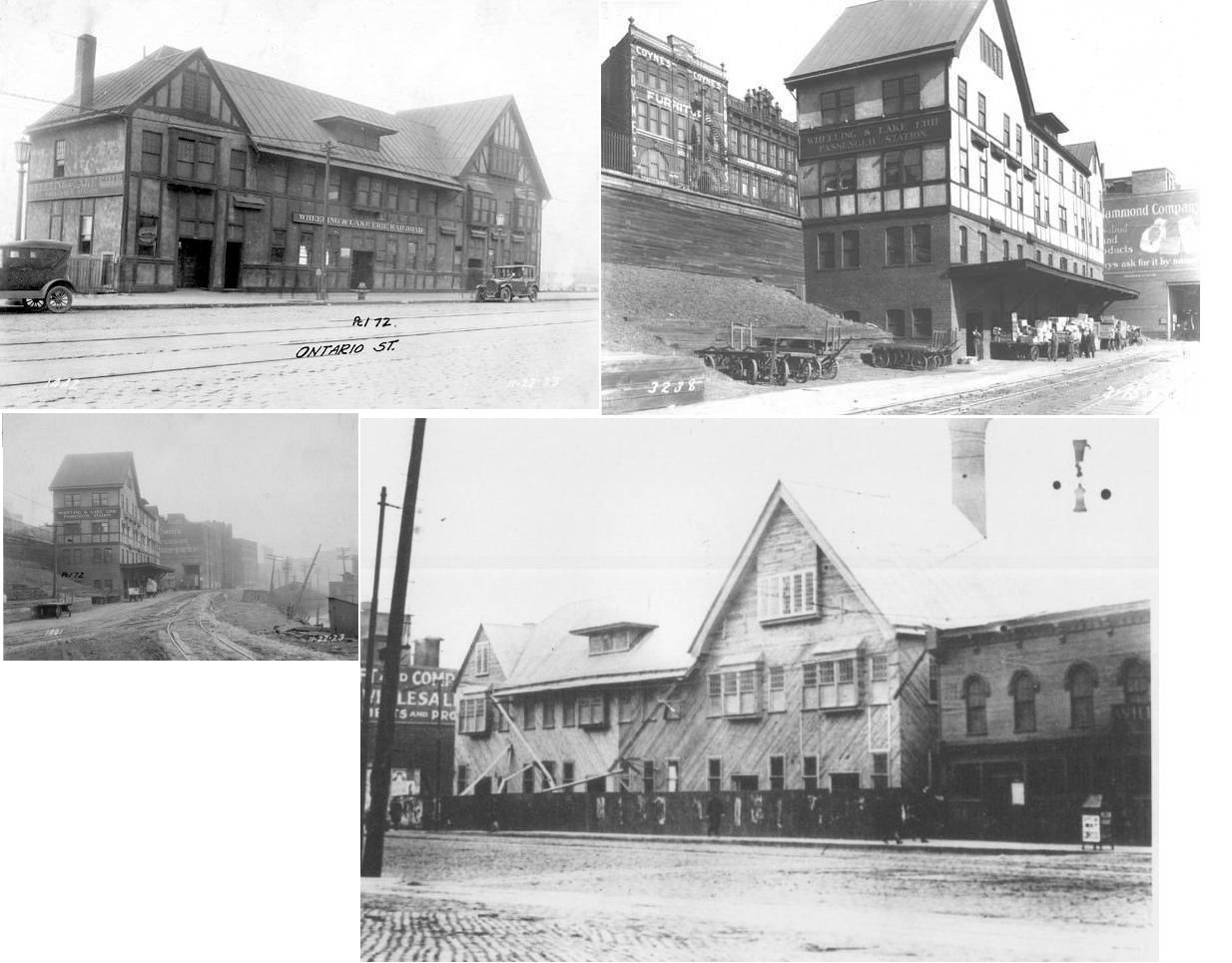
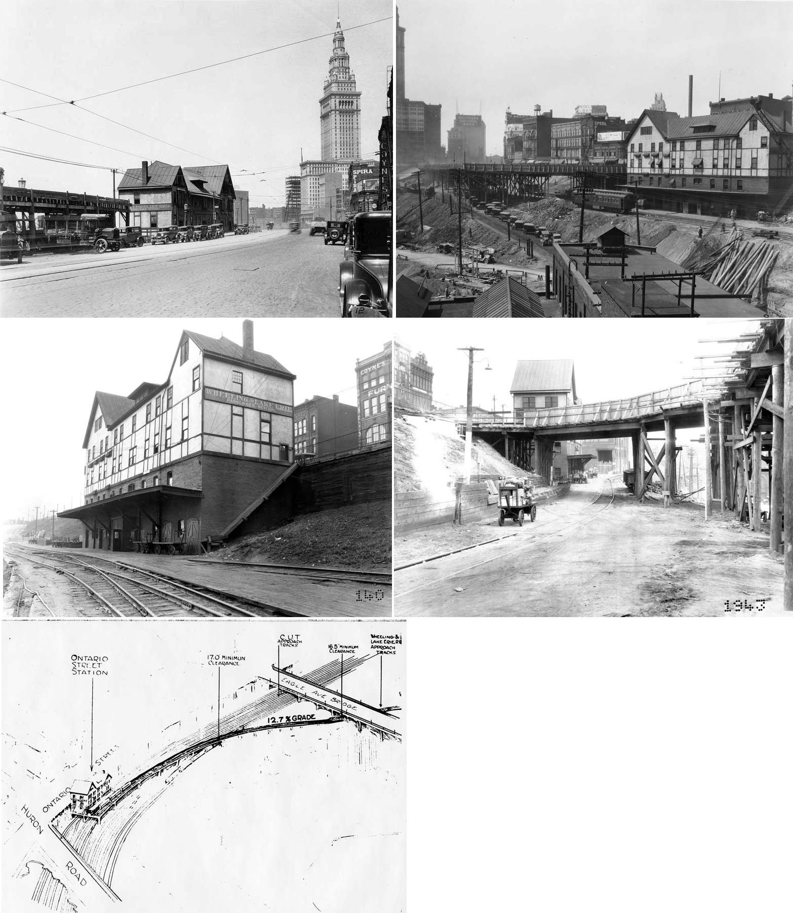
| Cleveland (Vinegar Hill) |
(W&LE) |
The CV built a station on Ontario Street in the Vinegar Hill area in 1883. This may have just been a repurpose of existing smaller storefronts here on the corner of Huron and Onatrio Streets. | ||||||
| Cleveland (Vinegar Hill) |
|
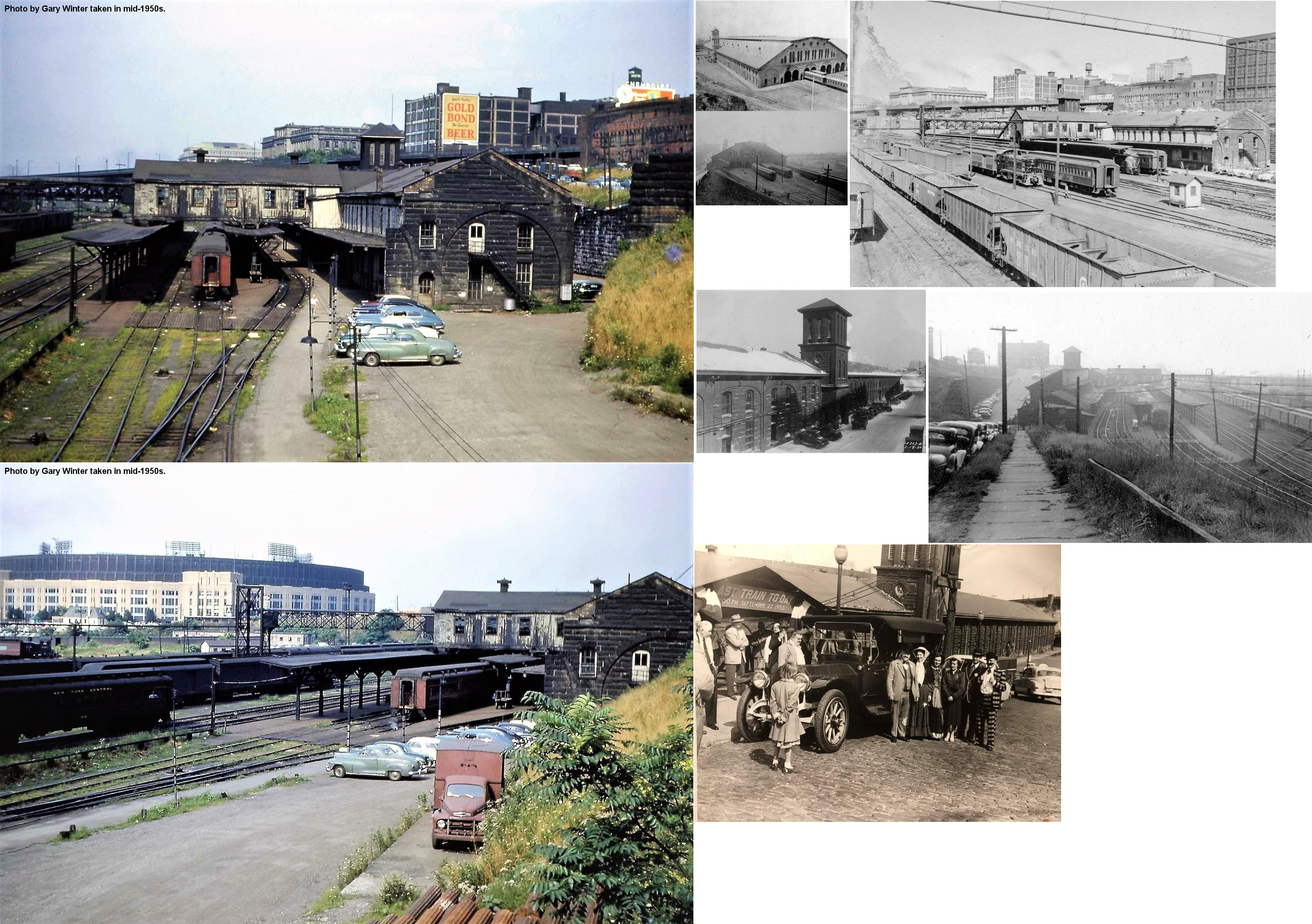
After the W&LE took over the CV, they replaced the above station with a new one built next door after the businesses along that stretch of Onatrio Street were demolished. The station was built in 1909 and located at 2260-2270 Ontario Street (GPS: 41.496442, -81.690130) at the foot of Vinegar Hill. It was torn down in January, 1929 in order to lay the approach tracks for the new Cleveland Union Terminal. See more photos here. | ||||||
| Cleveland (Commercial Road) |
|
When the Vinegar Hill depot was torn down in 1929, the W&LE used the Erie station on Old River Road. In 1935 the W&LE built a small station on Commercial Road. It was only in service for three years until passenger service ended. | ||||||
| Cleveland (Broadway Avenue) |
|
There was a depot on Broadway Avenue just southeast of Union Avenue. It was on a siding on the south side of the main line. | ||||||
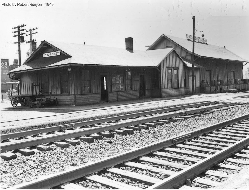
| Cleveland (Newburgh) (E. 93rd Street) |
|
This passenger station was at 3959 East 93rd Street across from Booth Avenue at GPS: 41.450911, -81.621137. It was on the east side of the street and the south side of the tracks. It was built in 1909. This was near the location of the earlier CC&S flag stop known as Woodland Hills. | ||||||
| Cleveland |
|
The East 55th Street station was on the east side of East 55th Street at McBride Avenue at 41.471993, -81.651046 on the south side of the tracks. As of 2019, the foundation of this station was still visible. When the 55th street underpass was built around 1907, the railroad moved the station a few feet back away from the tracks and built a new umbrella shed. | ||||||
| Cleveland (E. 55th Street) |
|
The East 55th Street freight station was on the east side of East 55th on the north side of the tracks at GPS: 41.472800, -81.651172. It was likely torn down when the Kroger Grocery warehouse was built there. | ||||||
| Cleveland (Newburg) (E. 93Rd Street) |
|
This combination freight and passenger station was on the north side of Richmond Avenue at East 93rd Street. It was on the south side of the tracks at GPS: 41.451952, -81.622196. This was the first Erie station in this area and the Lee & Miles Road station was built in 1948 to replace the Richmond/East 93rd Street station. | ||||||
| Cleveland (Corlett) |
|
This pre-1890s station was on East 131st Street at Miles Avenue at GPS: 41.445441, -81.591358. | ||||||
| Cleveland |
C&M RR (ERIE) |
The first passenger station built by the Erie predacessor companies in Cleveland was built by the Cleveland & Mahoning RR and was on Columbus Street. The C&M opened in 1857 and was leased to the A&GW in 1863. | ||||||
| Cleveland |
 (ERIE) |
The first A&GW depot was on the west side of Scranton Road just north of University Road. It was completed in 1863 and opened in 1864. It featured a dining room and 16 apartments on the second floor (Western Reserve Chronicle, 1-20-1864). This station burned down less than a year later on November 23, 1864 when a nearby sleeping car caught fire from a faulty stove pipe. The fire jumped from the car to the depot (Cleveland Daily Leader 11-26-1864). | ||||||
| Cleveland |
(ERIE) AND (Big 4) |
After the railroad moved a small paint shop building near the site of the burned depot to be used as a temporary station, a new permanent depot was built on the site of the destroyed depot and opened in 1865. The 1875 and 1879 Big 4 timetables list a stop at the "A&GW Depot." | ||||||
| Cleveland (Vineyard St.) (S. Water St.) |
(ERIE) AND (Big 4) |
This station was built in 1881 by the NYP&O (later Erie) and was located on Old River Road in the Flats. It was closed as a station in 1949 and was "Shorty's" nightclub in the 1980s. It was in the area bound by James Street, Superior Avenue (viaduct), South Water Street (Columbus Road), and Merwin Avenue at GPS: 41.495999, -81.699331. On old Sanborn maps, the station is labeled as the Cleveland Central Passenger Depot (1896 map). It is labeld as the CCC&I station on the 1886 map as that railroad was also a tenent. The Big 4 called this the Vineyard Street Station early on and and the South Water Street Station in 1909 (as Vineyard Street was the previous name of Water Street). The Big 4 eventually bypassed the station leaving the Erie as the lone occupant. The 1918 NYC (LS&MS Lakeshore Line) timetable lists this station stop, but by the 1923 timetable the station was bypassed. | ||||||
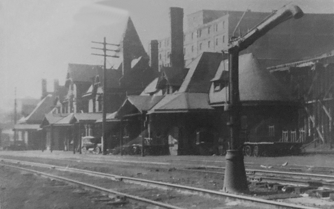
| Cleveland (Scranton Road) |
(ERIE) |
In 1886, there were four NYP&O freight houses on the SE side of Scranton Road where it intersects with Carter Road. The first freight house near Carter Road had a head house with offices. The photo shows two of those buildings. | ||||||
| Cleveland |
(ERIE) |
There was a freight house on the NE corner of River Road and Elm Street (next to the bridge). This area is now (2021) a parking lot. | ||||||
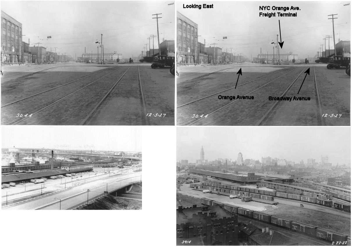
| Cleveland (Broadway Avenue) |
|
This was the Broadway Avenue passenger station. It was opened in 1883 and closed on February 1, 1928. It was on the south side of Broadway at East 14th Street. The station was on the north side of the tracks. It was next to the Broadway Freight Terminal. | ||||||
|
Cleveland (Broadway Avenue) |
|
The Broadway Avenue Freight Terminal stretched along Broadway Avenue from East 9th Street SE toward East 14th Street. For a short time until 1930 the Broadway Avenue passenger station sat at the SE end of this terminal. The NYC's Orange Street Freight Terminal was to the SE across Broadway Avenue. | ||||||
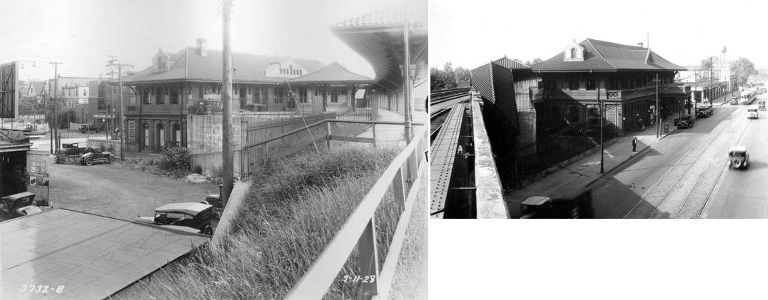
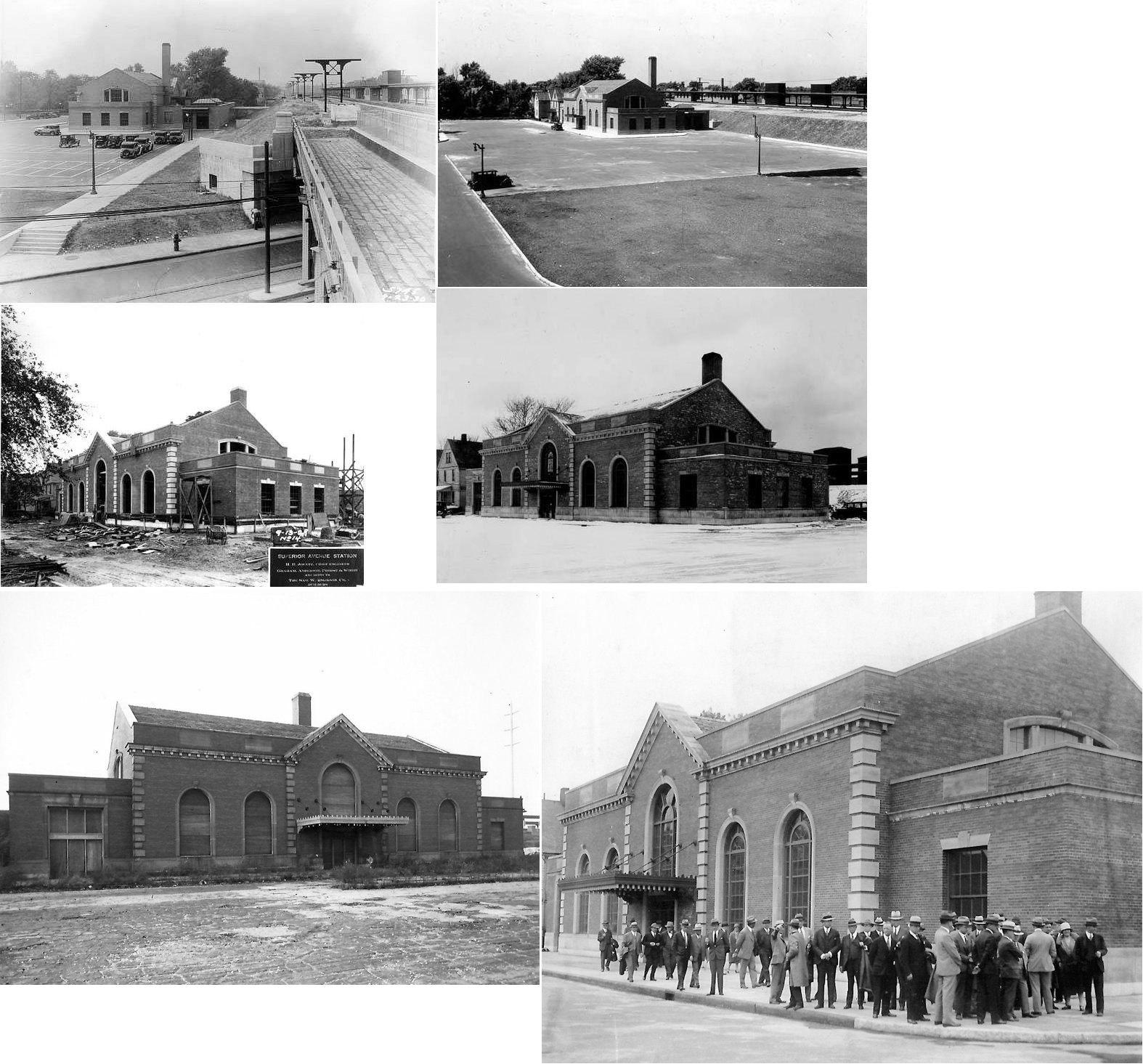
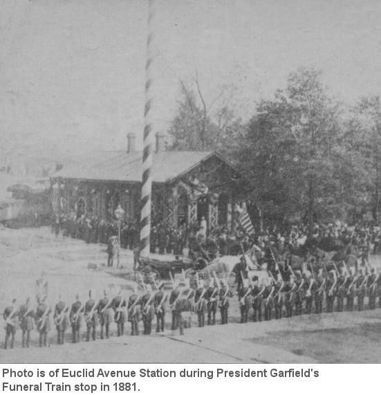
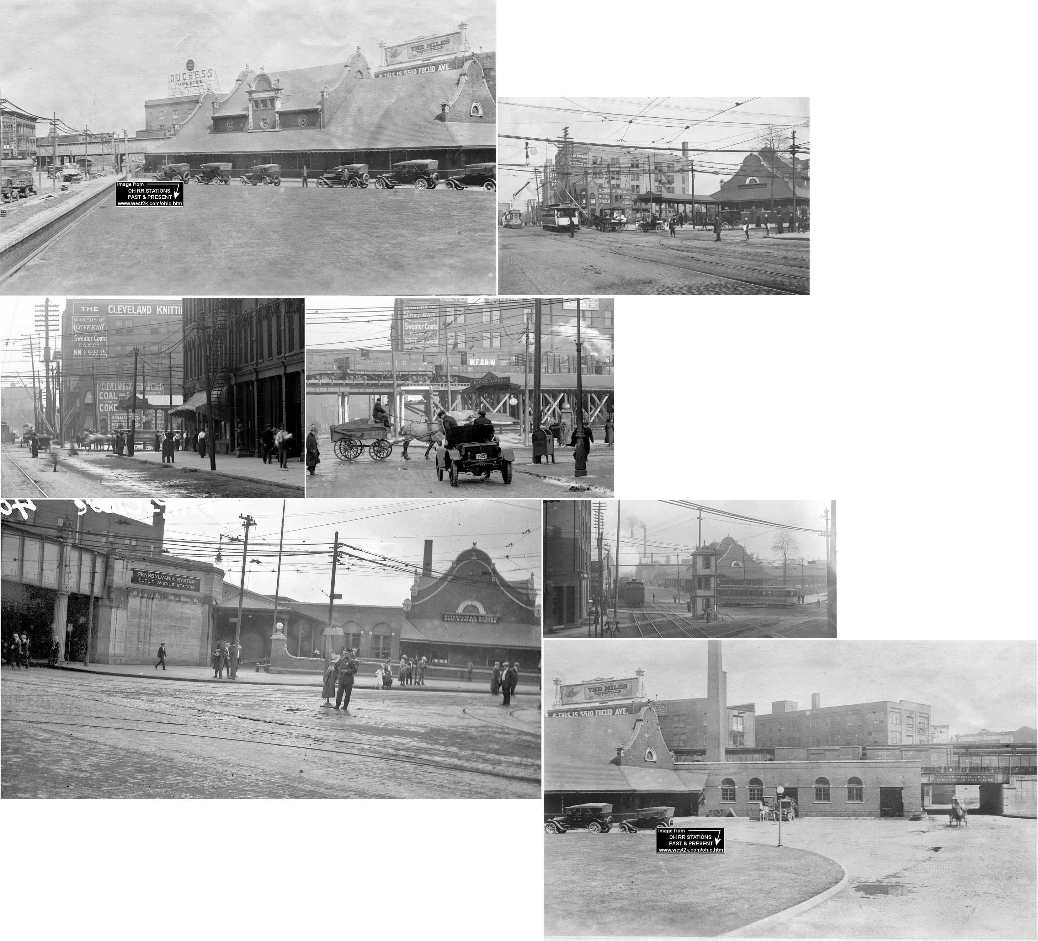
| Cleveland (Euclid Avenue) |
|
This station was at 12107 Euclid Avenue and was removed as part of the Cleveland Union Terminal (CUT) project around 1928-1930. Replaced by CUT and NKP/NYC station "East Cleveland" which was located 1 mile east at Superior Avenue. | ||||||
| Cleveland (East Cleveland) |
AND |
Built in 1929, this station was on the corner of Superior Avenue (see above) and Euclid Avenue and known as the East Cleveland stop on the NKP and NYC. It was on the south side of Superior Avenue on the SE side of the tracks at GPS: 41.522877, -81.591881. There was a concrete subway and stairs that led to waiting shelters on both sets of tracks. The station is shown on page 5 of the 1912-Dec. 1951 vol. 9, 1926-Oct. 1949 Sanborn Map. | ||||||
| Cleveland (East Cleveland) |
|
The NKP used this station on Superior Avenue temporarily while the one listed above was being built. I do not know exactly where it was or if it was built for this purpose or recycled from another use. It appears to have been built previously for another use with a wooden walkway to the tracks added. | ||||||
| Cleveland (Ivanhoe Road) |
|
There was a freight station on the NE side of Ivanhoe Road NW of Euclid Avenue at GPS: 41.548103, -81.567672. This station was 3,745 square feet with a car standing capacity of five. | ||||||
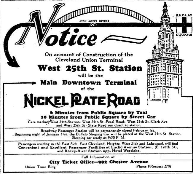
| Cleveland (Pearl Street) (W. 25th Street) |
|
This passenger station was on Pearl (West 25th) Street, just north of where Swift Avenue is today and West 25th is carried over the tracks by an overpass. The station was on east side of the street and the north side of the tracks. This was the main downtown terminal of the NKP during construction of Cleveland Union Terminal. | ||||||
| Cleveland (Pearl Street) (W. 25th Street) |
|
There was a freight station on the west side of the tracks at the corner of Fillmore and Empress Streets. It was just west of the Swift Meat Storage facility (still standing right next to the West 25th Street viaduct), at what is now the north end of West 27th Street at GPS: 41.478383, -81.700770. | ||||||
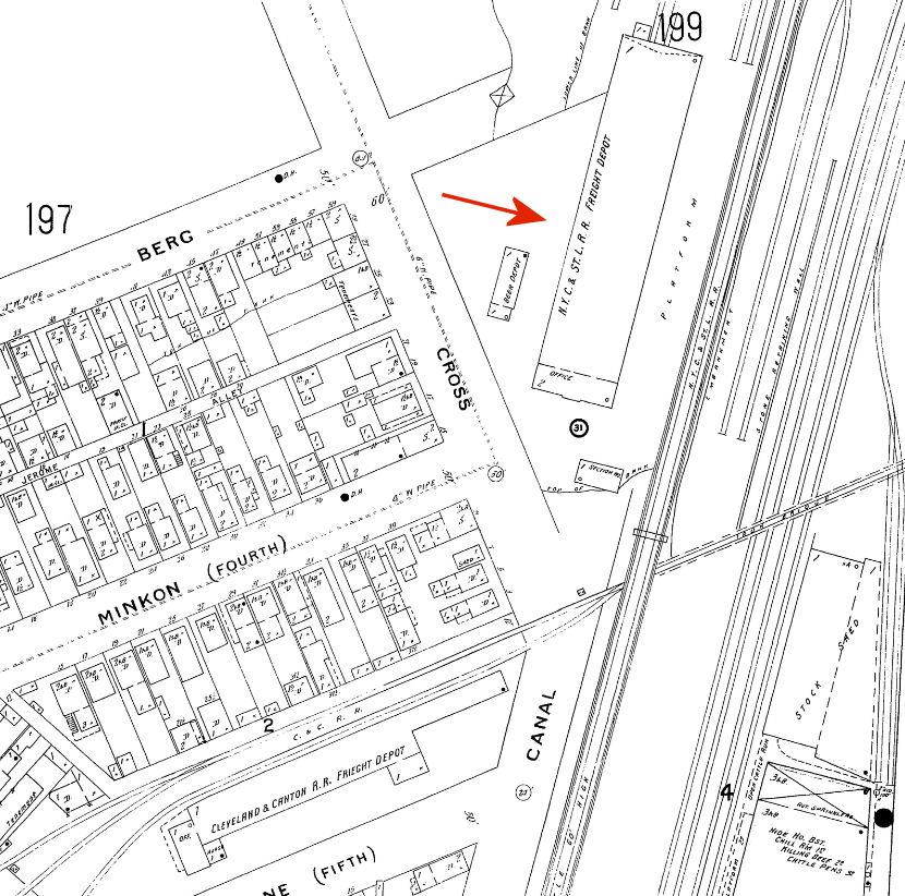
| Cleveland |
|
According to 1896 Sanborn maps, there was an NKP freight house on the north side of Canal Street at the intersection of Cross Street and Third Street. This is now in the vicinity of Commercial Road and where Minkon Street used to be. Most of the streets in this area are now gone or have been re-routed, but it was in the vicinity of GPS: 41.491628, -81.684976. The NKP freight station was about 150' NE of the W&LE (CC&S) freight station that is still standing on Commercial Road. This was the NKP freight station for this area before the Broadway Freight Terminal was built. | ||||||
| Cleveland |
|
There was a freight station on the west side of East 79th Street between Grand and Woodland Avenues at GPS: 41.485918, -81.633410. It was on the south side of the tracks. This was where the East 79th Street RTA stop is today (2010). | ||||||
| Cleveland (110th Street) |
|
There was a freight station on the east side of 110th Street north of Detroit Avenue at GPS: 41.482866, -81.762123. The freight house was only 1,855 square feet, but had a car standing capacity of 10 cars. | ||||||
| Cleveland (Becker Ave.) |
 (NKP) |
This station was on the 2nd (chronologically) Cleveland, Painesville & Ashtabula RR, an 11 mile line that ran from Euclid to the Becker Avenue depot in the 1870s-1880s. The CP&A and was later acquired by the NKP. This line is not to be confused with the earlier CP&A that eventually become part of the LS&MS. In August 1879 the Lake View and Collamer Railroad was sold at foreclosure sale and then operated as the Cleveland, Painesville and Ashtabula Railroad. It was also known as the Euclid & Collamer Railroad. The Nickel Plate acquired control in 1882, and the part parallel to Euclid Avenue became part of its main line. The other part of the line was then abandoned. The Becker Avenue station, the western terminus of the line, was on the SE corner of East 71st Street (formerly Becker Avenue) and Donald Avenue at GPS: 41.522990, -81.639505. | ||||||
| Cleveland (Lakeview Ave.) |
(NKP) |
The Lakeview Avenue station was at approximately GPS: 41.524707, -81.602910 on what is now Lakeview Road just south of Ingomar Avenue. | ||||||
| Cleveland (Avenue House) |
(NKP) |
The Avenue House station was likely near where the tracks crossed Elsinor Avenue to the NW of Euclid Avenue in the vicinity of GPS: 41.528786, -81.586988. The station was named "Avenue House" after the "Euclid Avenue House" (owned by J.M. Richards), a resort/hotel that sat between the RR and Euclid Avenue on the block that is bordered today by Elsinor, Holyoke and Euclid Avenues. The name of the station was likely shortened to "Avenue House" to avoid confusion with the Euclid station, which was the eastern terminus of the line. There was probably no actual station building here since the Euclid House was only a short walk from the tracks. | ||||||
| Cleveland (Collamer Ave.) |
(NKP) |
It was listed as a flag stop on on the NKP, mentioned only in the index of an old Official Railway Guide. It was on Collamer Street in the vicinity of GPS: 41.543058, -81.573066. There may have been a station here during the CP&A years. | ||||||
| Cleveland (Collinwood) |
(NKP) |
|||||||
| Cleveland (Euclid Avenue) |
|
The first station here was on the southeast cormer of Euclid and Willson (now E. 55th) Avenues. According to the 1950 book, Cleveland: The Making of a City, Jared Willson (the namesake of Willson Avenue that was renamed to East 55th Street in 1906) sold a portion of his land in order for the C&P to erect "a little wooden building" in 1856. It is shown on maps from 1868 and was located at GPS: 41.503881, -81.651355. Lincoln’s funeral train also used the station in 1865 after traveling from Buffalo and turning around at Cleveland Union Depot. | ||||||
| Cleveland (Euclid Avenue) |
|
A second generation station was built here in 1873. | ||||||
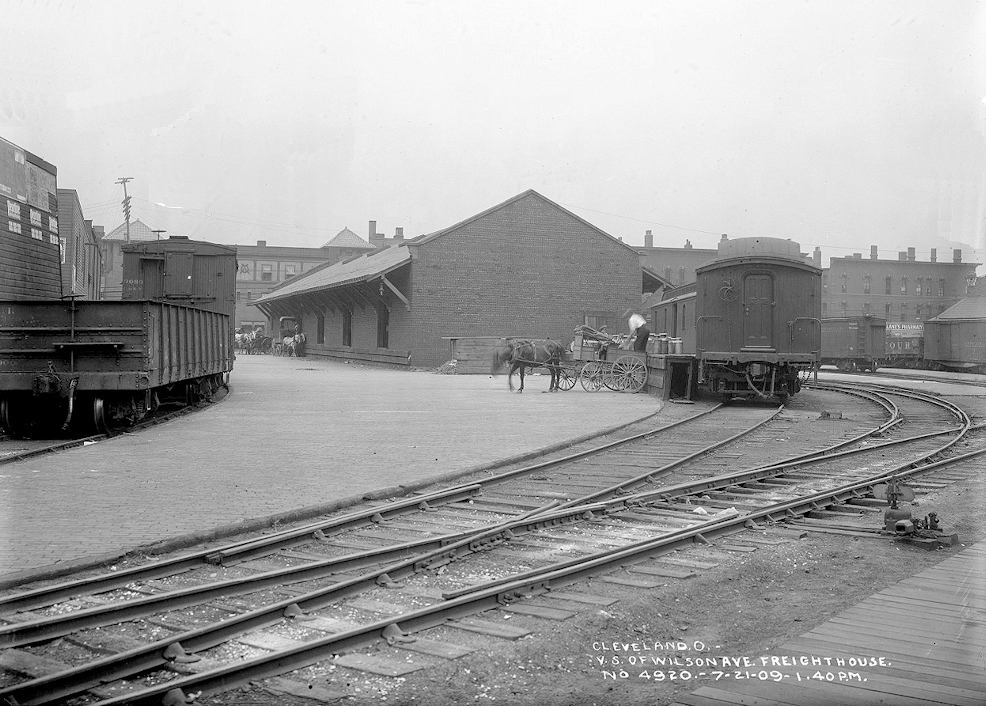
| Cleveland (Euclid Avenue) |
|
According to 1886 maps, the C&P "Euclid Avenue Freight Depot" was in fact two blocks north of Euclid Avenue on Perkins Avenue. It was on Perkins between E. 40th (formerly Case Ave.) and E. 55th (Formerly Wilson Ave.) Streets. The station was on the south side of the street on the NE side of the tracks at GPS: 41.506887, -81.654472. The photo shows the "Wilson Avenue Freight House" which I believe is the same station as described. | ||||||
| Cleveland |
|
The original C&P freighthouse here was a re-purposed grain elevator that was located "near the entrance to the harbor." It was destroyed by fire from a lightning strike on September 16, 1869 and the railroad did not have it insured. Following the fire, frieght was handled "at the pier freighthouse just west of the old passenger depot" (Cleveland Plain Dealer, 09-17-1869). | ||||||
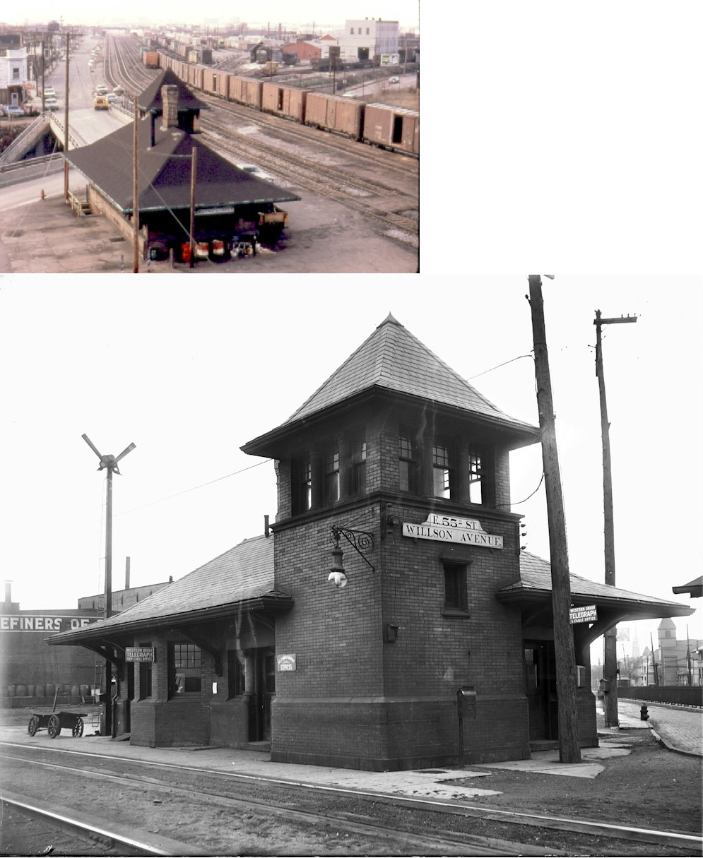
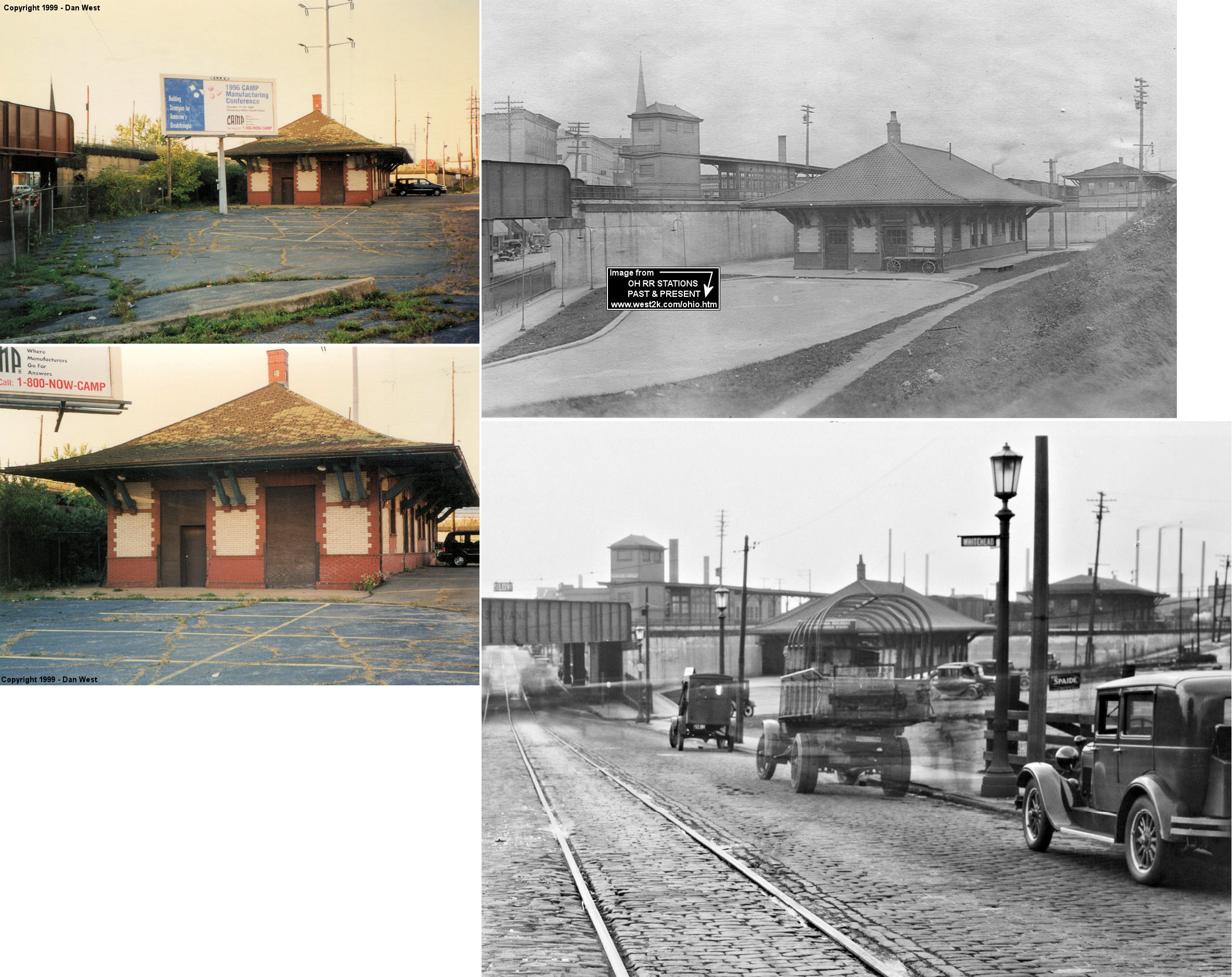
| Cleveland (Euclid Avenue) |
 |
The PRR replaced the above 1873 C&P passenger station at East 55th and Euclid Avenue in 1902 with this "suburban station" (according to PRR Chronologies).The tracks were elevated in 1914 and the viaduct was added to the station. It closed 1965 and was torn down in 1973 after the roof collapsed. It was at GPS: 41.503881, -81.651355. Since the PRR wasn't a tenant in the new Cleveland Union Terminal, this was the railroad's main station in Cleveland after the old Union Depot closed. | ||||||
| Cleveland (Euclid Avenue) |
|
When the new PRR station was built in 1914, a larger freight house was also built across the tracks from the passenger station to the southeast at GPS: 41.503236, -81.649933. It was accessed from the passenger station parking lot via a subway under the tracks. | ||||||
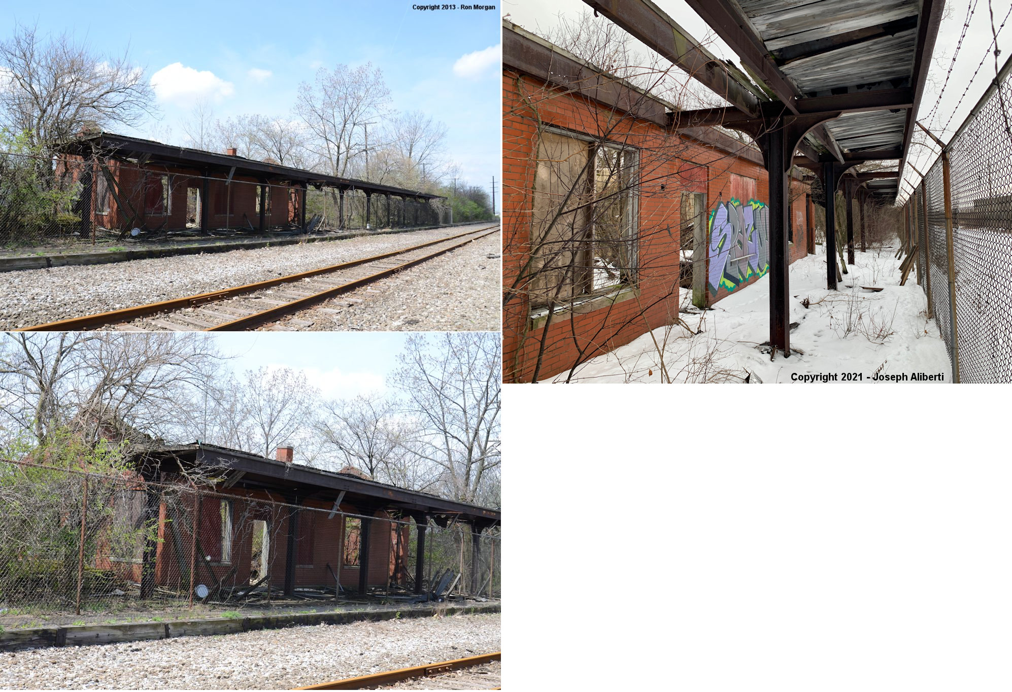
| Cleveland (Harvard Avenue) |
|
This station sat between Harvard and Broadway Avenues on the east side of the tracks at GPS: 41.448525, -81.626882 in Newburgh. It was built in 1907 and torn down in October 2007 after being vacant for years. | ||||||
|
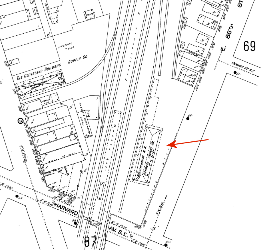
Cleveland (NewburgH) (Harvard Ave.) |
|
The Newburgh Freight House, was on the north side of Harvard Avenue along East 86th Street (at GPS: 41.449116, -81.626997). This station was also built in 1907 when the new passenger station was built along the newly elevated tracks. | ||||||
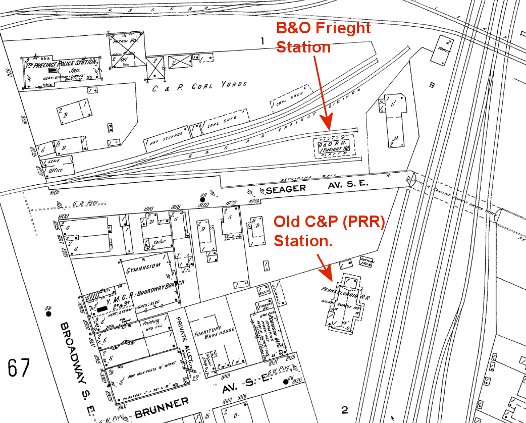
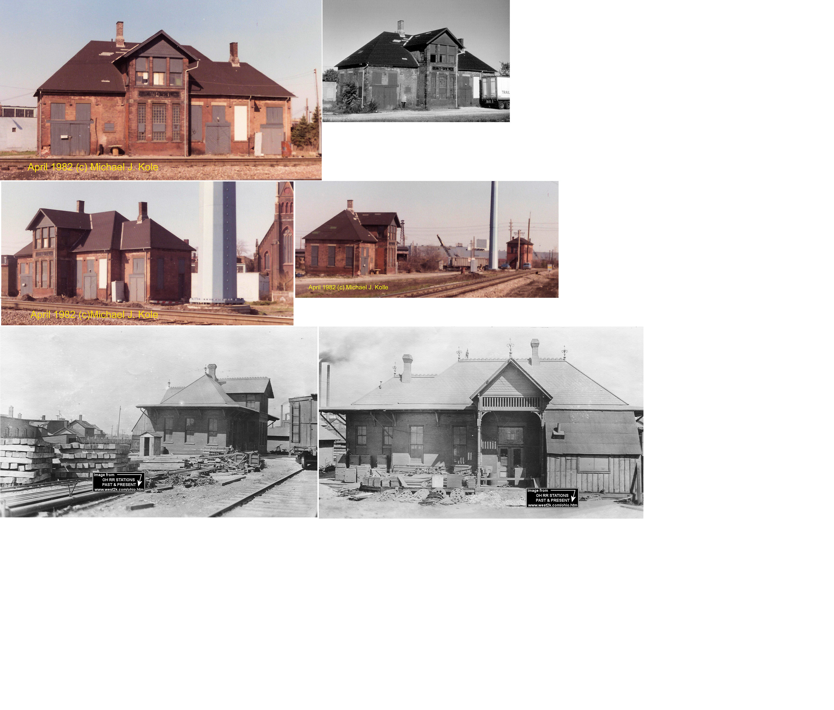
| Cleveland (Harvard Ave.)(Brunner Ave.) |
|
Before the passenger station above was built at Harvard & Broadway, the C&P had a station just up the tracks to the north at the end of Brunner Avenue at GPS: 41.450478, -81.628055. A station here was shown as in service as early as 1874. According to PRR valuation records, a new station was built here in 1883. The station was on the west side of the tracks. It went out of service when the new Harvard Avenue station was built in 1907. It then served as a PRR signal supply house and other railroad functions until at least the early 1980s. | ||||||
| Cleveland |
|
There was a small freight house on the north side of Seager Avenue (now Booth Avenue) on a transfer track at GPS: 41.450930, -81.628446. This was just to the NW of the Brunner Avenue passenger station. | ||||||
| Cleveland |
|
There was a C&P freight house on the SE corner of Broadway and Harvard Avenues when the tracks were still at street level. This station was at GPS: 41.448681, -81.627370. It is shown on the 1896 map and was likely torn down when the tracks were elevated. | ||||||
| Cleveland (Davenport St.) |
|
There was a large freight station, built in 1903, at the corner of Davenport Avenue and East 16th Street stretching toward 14th Street at GPS: 41.509340, -81.686065. It was on the north side of Davenport. Although the street is now Davenport Avenue, it was on old timetables as Davenport Street. The freight station was 34,272 square feet with a standing capacity of 95 cars. | ||||||
| Cleveland (Woodland Avenue) |
|
The Woodland Avenue Passenger Station was on the SE corner of Woodland and East 79th Street at GPS: 41.488004, -81.633640. Across the tracks to the SW in the old days was the "City of Cleveland Workhouse, House of Refuge and Correction." According to PRR valuation records, the station was built in 1887. | ||||||
| Cleveland (Woodland Avenue) |
|
The Woodland Avenue Freight Station was on the north side of Woodland Avenue on the SW side of the tracks at GPS: 41.488874, -81.635180. The foundation of the freight house and the remnants of the small freight yard of spurs are still there but walled off. According to PRR valuation records, the station was built in 1897. | ||||||
| Cleveland (Wason Street) |
|
The PRR Wason Street Freight Depot was on the north side of Hamilton Avenue at Wason Street (now East 38th Street) at GPS: 41.516357, -81.667882. According to PRR valuation records, the station was built in 1913. | ||||||
| Cleveland (Cleveland Shops) |
|
The was a small depot near the corner of Hamilton and Lawrence (now E. 33rd) Streets at GPS: 41.515087, -81.670593. This station is shown on the 1896 Sanborn map. On old timetables it was referred to as "Cleveland Shops." | ||||||
|
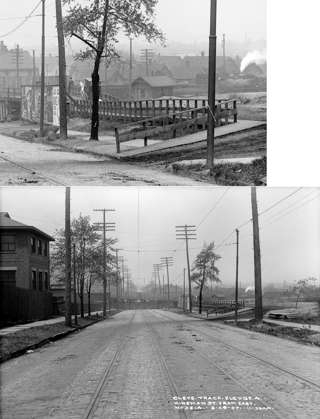
Cleveland (Kinsman Road) |
|
There was a station-like building (pictured) on Kinsman Road (then Kinsman Street) where the tracks used to cross between 82nd and 90th Streets. This does not appear on public passenger timetables; it may have been for employees of the PRR yard there or used for special purposes. It may have been on an 1882 C&P timetable, but that has yet to be confirmed. This location was near the Encampment at Woodland Hills so it may have been used for that (excursion trains to the camp stopped here). | ||||||
|
Cleveland (Dock 20) |
|
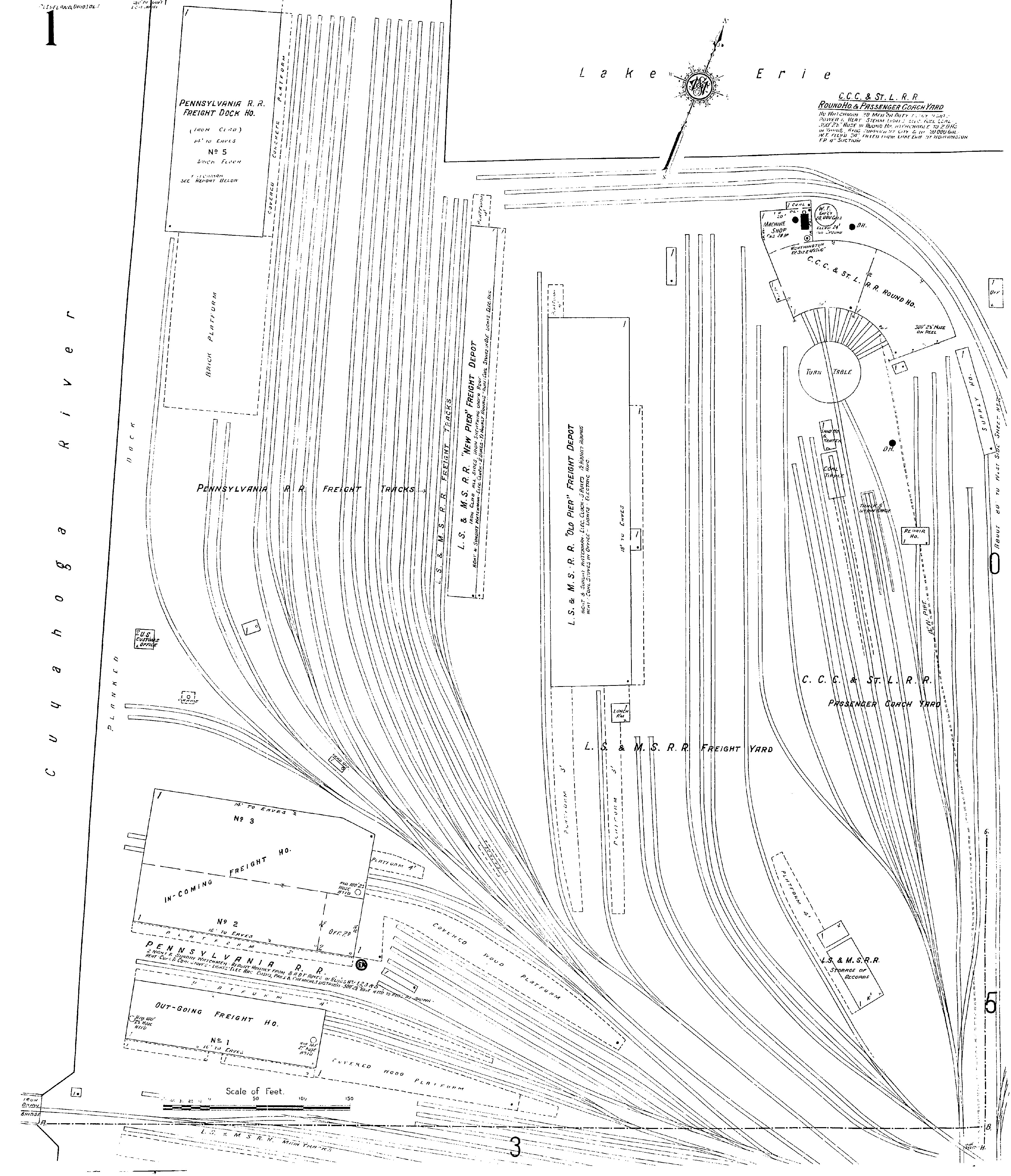
The C&P had inbound freight houses (adjacent Freight Houses #2 and #3) and an outbound freight house (Freight House #1) on the east bank of the Cuyahoga River near the mouth of the river on Dock 20. They were in the area of GPS: 41.500993, -81.708514. These two freight depots were across the tracks to the north of the Union Freight Depot (north of the intersection of Old River Road and Front Avenue). Both of these freight stations were built in 1870 according to PRR valuation records. Here is a map from 1912 showing all the freight stations in that area. The PRR valuation records from 1917 list four freight houses on Dock 20. Freight houses 1, 2, and 3 were built in 1870, and freight house 4 was built in 1908. The 1912 map linked above shows freight houses numbered 1, 2, 3, and 5. That numbering could be a mistake on the map or the valuation records. | ||||||
|
Cleveland (Dock 20) |
|
The C&P also had a freight station north of the inbound and outbound stations listed above at GPS: 41.502664, -81.710005. This station occupied the NE corner of at the mouth of the Cuyahoga River and was served by serveral north/south spurs. This station later became known as the PRR Lake Freight Depot and was also known as Freight Dock House No. 5 at Dock 20 (in the PRR valuation records it may have been listed as #4). | ||||||
|
Cleveland (Dock 22) |
|
PRR valuation records indicate that there was a frame freight house on Dock 22 that was built in 1896. | ||||||
| Cleveland |
(NYC) AND (BIG 4-NYC) |
These two railroads shared the Union Freight Depot which was on the NW side of Front Avenue between Old River Road and West 10th Street (1887 map). Later this station was referred to as the West 11th Street Freight Depot. | ||||||
|
Cleveland (E. 40th St.) |
(NYC) |
This station is listed on the 1918 NYC timetable, but was removed by the 1923 timetable. 40th Street was previously known as Case Street. | ||||||
|
Cleveland (E. 55th St.) |
(NYC) |
Like the station above, this station is listed on the 1918 NYC timetable, but was removed by the 1923 timetable. 55th Street was previously known as Wilson Street. | ||||||
|
Cleveland (Coits) |
(NYC) |
This station was on the west side of Coit Road, on the south side of the tracks in the 1870s. By the 1880s there was a new Coits station on the east side of Eddy Road on the north side of the tracks. This station is listed on the 1918 timetable, but was removed by the 1923 timetable. | ||||||
|
Cleveland (Collinwood) |
(NYC) |
The first frame station was built here in the 1870s. It was on Parker Street just east of Adams Street (both streets gone or renamed now). | ||||||
|
Cleveland (Collinwood) |
(NYC) |
The frame above station was replaced with a brick station in the early 1900s. | ||||||
|
Cleveland (Detroit Avenue) |
(NYC) |
This was also known as the West Cleveland Passenger Depot. It was on the north side of Detroit Avenue just west of Berea Road. The station was on the west side of the tracks. | ||||||
|
Cleveland (Detroit Avenue) |
(NYC) |
The Detroit Avenue freight station was 5,760 square feet with a car standing capacity of 20. | ||||||
| Cleveland |
(NYC) |
There was a small passenger depot on the north side of Hamilton Avenue between East 33rd and East 38th Streets. It was just to the west of the LS&MS roundhouse and may have served the shops and industries in the area. This station is shown on the 1886 and 1896 maps. | ||||||
| Cleveland |
(NYC) |
The LS&MS had a freight house on the south side of the tracks in the vicinity of Davenport Avenue and East 20th Street. | ||||||
|
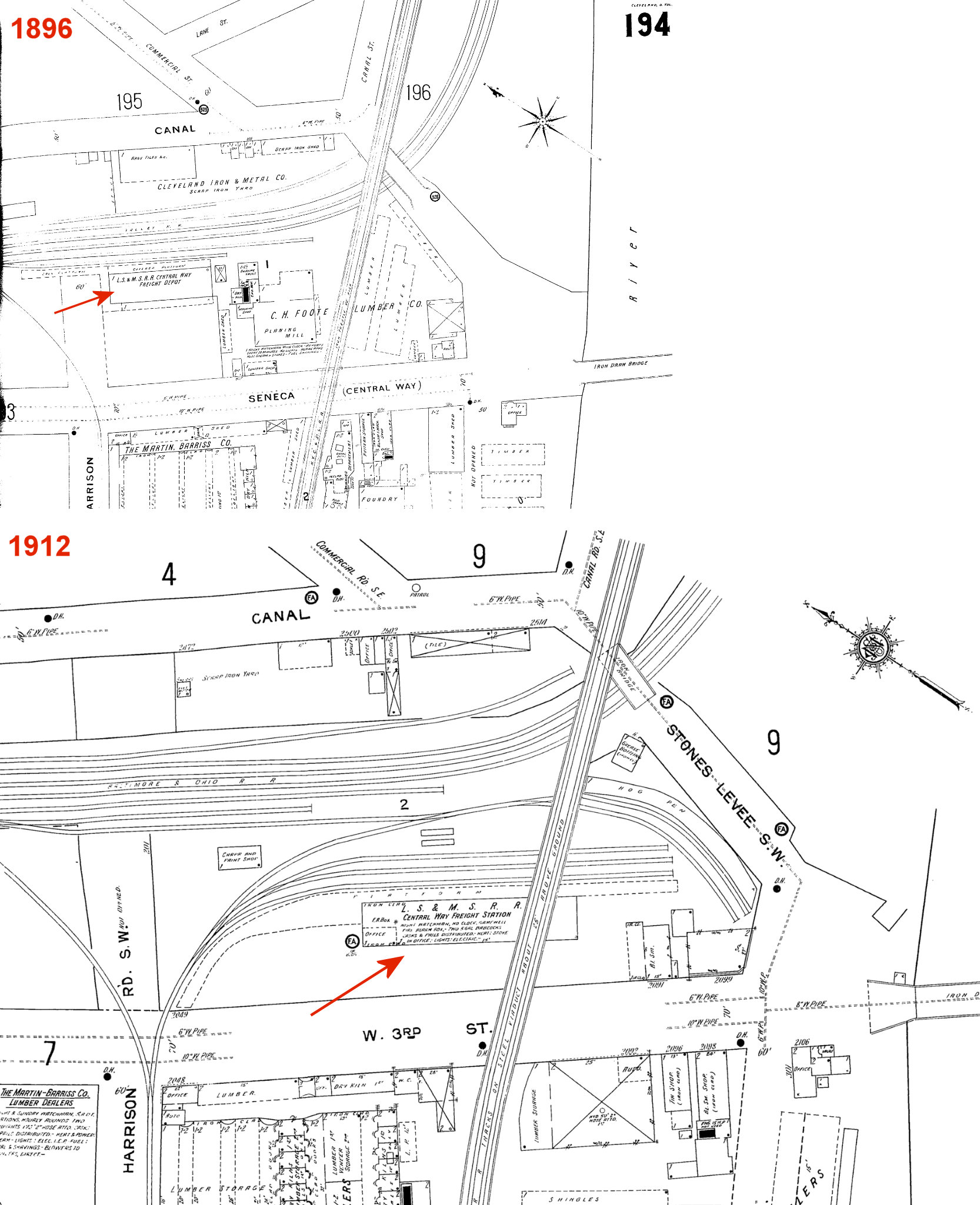
Cleveland (Central Way) |
(NYC) |
According to 1886 Sanborn maps, there was a freight depot between Canal Street and Central Way, just west of the Canal Street/Commercial Street intersection at approximately GPS: 41.489867, -81.686520. This was known as the LS&MS Central Way Freight Depot. According to maps from 1912, a new Central Way freight station was built slightly to the SE of the original one on the NE side of West 3rd Street just north of Canal Road. The station was partially under the NKP tracks which passed overhead there on a trestle. The station was on a spur that branched off to the south from near Harrison Street. | ||||||
|
Cleveland (Willow St.) |
(NYC) |
This was known as the Willow Street Freight Depot. It was, however, at the intersection of what was formerly Toledo and Lloyd Streets. There are no streets in this area now. This is on the west bank at the mouth of the Cuyahoga River. The modern location would be just north of the River Road lift bridge over the ship channel. The freight depot was on the south side of the main line on the north bank of the ship channel. | ||||||
|
Cleveland (Wason St.) (38th St.) |
(NYC) |
There were freight stations (inbound and outbound) on the NE and SE corners of King and Wason (now called E. 38th) Streets. The stations, both with frontage on King Street, were known as the Wason Street Freight Depots and later as the 38th Street Freight Stations. Alternately, in 1934, these stations were known as Wason Street and East 40th Street freight stations. They were on several sidings that came off the main line there. In 1934 the Wason Street station was 32,185 square feet with a standing capacity of 72 cars, and the East 40th Street station 50,050 square feet with a standing capacity of 93 cars. These building may have been leased by the railroad rather than owned. | ||||||
|
Cleveland (Old Pier) |
(NYC) |
The LS&MS had another freight house due north of Union Freight Depot on the lake shore. Later this became known as the "Old Pier Freight Depot." Just to the NE of this depot was a CCC&St.L roundhouse. | ||||||
|
Cleveland (New Pier) |
(NYC) |
Sometime around 1910 the LS&MS built another freight house next to (to the west of) the "Old Pier Freight Depot." The new depot was called (you guessed it) the "New Pier Freight Depot." This may have also been called the West 9th Street Freight Station. | ||||||
|
Cleveland (105th Street) |
|
This more modern brick station was on the east side of East 105th Street at Dupont Avenue at GPS: 41.545028, -81.615168. It was built around 1910 to replace the older wood frame LS&MS station that still exists at 9920 Foster Avenue. After it closed in 1930, NYC passenger traffic from this station was shifted to the East Cleveland NKP/NYC station on Superior Avenue. | ||||||
| Cleveland |
|
There was a small freight house east of the 105th Street passenger station along Leuer Avenue at GPS: 41.545418, -81.613749. In 1934 the station was 4,680 square feet with a standing capacity of six cars. | ||||||
|
Cleveland (Orange Avenue) |
|
The Orange Avenue Freight Terminal was along Orange Avenue at East 22nd Street. In 1934 this station was 134,642 square feet with a standing capacity of 280 cars making it by far the largest freight terminal in the city. This building was leased from the NKP as indicated on the 1952 Sanborn map. The NKP's Broadway Freight Terminal was just to the NW across Broadway Avenue. | ||||||
| Cleveland |
|
There was a freight station on the west side of 152nd Street north of Saranac Road. | ||||||
| Cleveland |
|
Before the existing Amtrak station was built in 1977, this temporary station was used from the start of service in 1975. It was at 400 East Memorial Shoreway. --Note by Cards84664. | ||||||
|
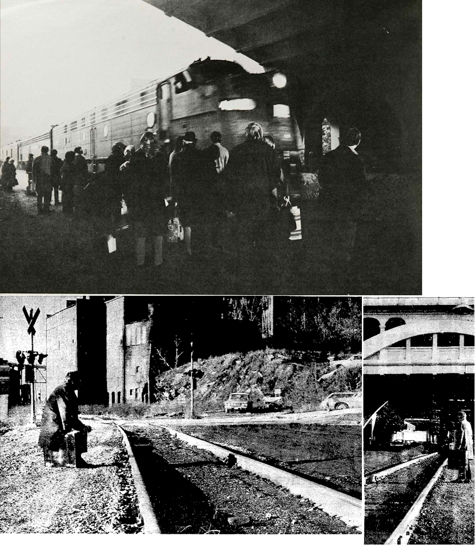
Cleveland (Superior Ave.) |
|
Here is how Amtrak started service in Cleveland. On and before April 30 1971, Cleveland Union Terminal had the following services: Penn Central, Erie-Lackawanna, Shaker Heights Rapid Transit, and Cleveland Transit System. When May 1st came around, the Penn Central Railroad quit the Buffalo-Chicago train. Amtrak didn’t originally plan to serve Cleveland, but there was some political maneuvering and Amtrak service actually started nine days later at Cleveland Union Terminal on May 10th, 1971. The service failed because New York, Pennsylvania, Indiana and Illinois did not subsidize the route, even though Ohio did, oddly enough. Because the service was ending on January 5th, 1972 Amtrak had to leave CUT to avoid the now-hostile Penn Central (Cleveland Union Terminals Company was formally absorbed by Penn Central in 1989) and their $250K rent that covered a full year of service (Erie Lackawanna kept paying the rent until Conrail took over their passenger train in 1976). Amtrak moved to a surface stop on the ex-Big Four tracks underneath Detroit-Superior Bridge on January 1st 1972 and stayed there until January 5th 1972. The 1971-72 service was called the Lake Shore, and the 1975 service (from the station listed above) is the Lake Shore Limited everyone knows now. The 1975 revival avoided the old CUT and Big Four right-of-ways, they switched back to the old NYC Main Line and the permanent Amtrak station was finished in 1977.--Note by Cards84664. | ||||||
| Dover Bay Park |
|
Old maps (1892) show a station here to serve the Dover Bay Park Country Club (now gone). It was on Clague Road in the vicinity of GPS: 41.477157, -81.882250. | ||||||
| Dover (West Dover) |
|
Old maps (1892) show a station on Bradley Road in the vicinity of GPS: 41.478009, -81.960385. | ||||||
| Euclid |
|
This station was on the west side of Chardon Road (formerly known as Lake Road) on the south side of the tracks at GPS: 41.572581, -81.536323. This was also probably the site of the station for the 2nd (chronologically) Cleveland, Painesville & Ashtabula RR, an 11 mile line that ran from Euclid to the Becker Avenue depot in the 1870s-1880s. The CP&A and was later acquired by the NKP. This line is not to be confused with the earlier CP&A that eventually become part of the LS&MS. In August 1879 the Lake View and Collamer Railroad was sold at foreclosure sale and then operated as the Cleveland, Painesville and Ashtabula Railroad. It was also known as the Euclid & Collamer Railroad. The Nickel Plate acquired control in 1882, and the part parallel to Euclid Avenue became part of its main line. The other part of the line was then abandoned. | ||||||
| Euclid (Nottingham) |
 |
The first station at Euclid was on the west bank of the Euclid Creek. It was built around 1852. In the mid 1860s, the LS&MS acquired the CP&A, built a new, larger station and changed the name of this stop to Nottingham in honor of Henry Nottingham a company supervisor. | ||||||
| Euclid (Nottingham) |
|
This passenger station was on the NW side of Syracuse Avenue (formerly South Depot Street). It was just to the NE of Brussels Road. The station was on the south side of the tracks. Also see listing for Noble station below. This station was built in 1913 according to NYC valuation records from the 1920s. | ||||||
| Falls Junction (South SoLON) |
|
The original Falls Junction depot was built in 1883 by the Connotton Valley Railway at the junction of Cochran Road and the tracks which served Chagrin Falls. The station was then known as South Solon. When the Austin Powder Company relocated in northeastern Ohio, it founded a company town known as Glenwillow and moved the depot there. As business and passenger traffic increased, the smaller, old station was demolished and replaced with the existing station in 1905. | ||||||
|
Glendale (Bedford) |
|
This stop was on the south side of West Glendale Avenue near Magnolia Avenue on the east side of the tracks at GPS: 41.396285, -81.543208. It is listed on the CC&S timetable from 1899. | ||||||
| Hills |
|
This flag stop was between Chamberlains (flag stop) and Chagrin Falls on Chagrin River Road in the vicinity of GPS: 41.405290, -81.402857 south east of Bentleyville. It is listed on an old CC&S timetable. | ||||||
| Lang & Cowan |
|
This flag stop was named after local property owners George Cowan and James Laing south of Solon Road in the vicinity of GPS: 41.384560, -81.500702. "Lang" with no "i" is used on the CC&S timetable, but the name is spelled "Laing" on the 1892 map. Richmond Road near here was formerly known as Laing Road and bisected the properties of Laing & Cowan. It's unclear exactly where this stop was or why it was here. | ||||||
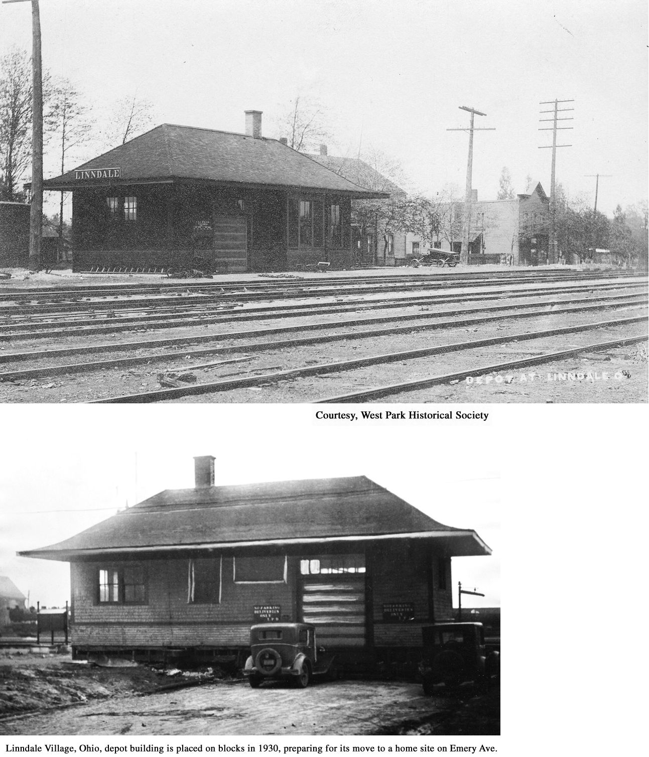
| Linndale |
|
The first station here was a two-story depot that was destroyed by a fire on April 13, 1907. Two clerks survived the fire by jumping from a second-story window. It was on the SE side of Zelis Road (formerly Snow Ave.) just SW of Park Street (which doesn't exist anymore, but was between West 119th and West 120th Streets) at GPS: 41.443363, -81.766710. | ||||||
| Linndale |
|
This was the second Linndale station which served until 1929 when it was replaced by the station listed below. It was located near the intersection of West 120th Street (formerly Grand Street) and Zelis Road (formerly Snow Avenue). After its service the station was moved to Emery Avenue just west of Bellaire Road (GPS: 41.443864, -81.772056) where it served as a residence until 1986 when it was razed to make way for the construction of Second Calvary Missionary Baptist church. | ||||||
| Linndale |
|
There was a freight transfer station here. It burned, along with 40 freight cars, in July 1910. | ||||||
| Linndale |
|
This station was built in 1929 and was the westernmost point where electric locomotives picked up passenger cars for the trip to Cleveland Terminal. | ||||||
| McKinley (Rockport) |
|
According to Rails Through West Park (2014) by Ralph A. Pfingsten, West Park Historical Society, this short-lived station was on the north side of Brookpark Road just east of W. 150th Street in the vicinity of GPS: 41.418632, -81.801617. The post office there was folded by 1903 and a planned allotment never got off the ground. The 1914 Cuyahoga County Atlas, however, still shows the McKinely station and post office. Some older maps label this station as "Rockport." | ||||||
| Newburgh |
|
The first W&LE station here was west of 91st Street where the PRR, Newburgh & South Shore and PRR junctioned. | ||||||
| Newburgh Heights |
|
See listing above for Cleveland (Brunner Avenue). | ||||||
| Newburgh |
|
This combination station was on Richmond Avenue SE just west of East 93rd Street. | ||||||
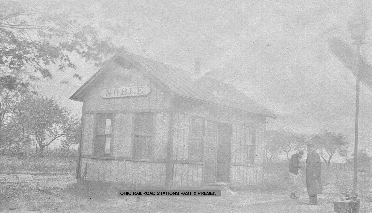
| Noble (Euclid) |
|
This station was on Babbit Road. According to NYC valuation records, this station was built in 1892. | ||||||
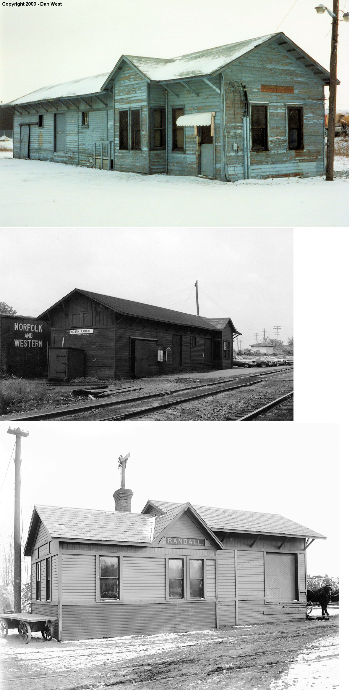
| North Randall |
|
This station was on the south side of the tracks behind 21221 Aurora Road at GPS: 41.426180, -81.530243. Was vacant and boarded up for a long time then torn down sometime in late 2006/early 2007. The first station here when the Cleveland & Mahoning Railroad came through in 1856 was called "Plank Road Station" named after a tavern that was there. Later it became just "Randall" station and then "North Randall" probably around the time the town was incorporated in 1908. | ||||||
| Olmsted Falls |
|
Although the existing station was built in 1876, the 1874 map of the town shows an earlier depot here on the north side of the tracks approximately across the tracks from where the existing station is now. | ||||||
| pARMA |
|
The original station here was 800 feet north of Brookpark Road. After a new station was built in 1909, this building served as the freight house. It was torn down in 1962. | ||||||
| pARMA |
|
This second generation station was built in 1909, closed in 1926. --Rails Through West Park (2014) by Ralph A. Pfingsten, West Park Historical Society. It was on the north side of Brookpark Road at approximately GPS: 41.418593, -81.776811. | ||||||
| Rocky River |
Rocky River Railroad |
The Rocky River station on the RRR was on the east bank of the river near where Sloane Avenue is at approximately GPS: 41.484944, -81.829138. The railroad (now where the NKP tracks are) turned south here and ended. | ||||||
| Solon |
|
The original station here was built prior to 1874. It burned in the early 1880s and was replaced by the station that still exists. | ||||||
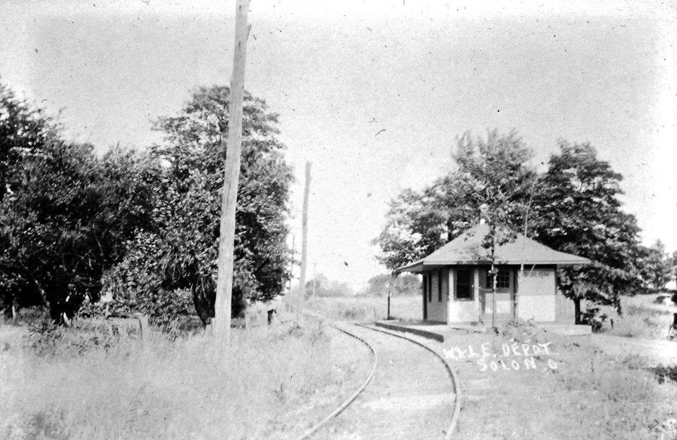
| Solon |
|
This station was on the old Chagrin Falls & Southern line. After 1905 this became a branch of the W&LE. There was originally a converted boxcar used as a station, but the station pictured was built in 1915. The station was on Kruse Drive in the vicinity of GPS: 41.392426, -81.444254. | ||||||
| Sorrento Park |
|
According to the 1888 NYLE&W Annual Report, a new passenger station was built here by a private party and transferred to the railroad free of charge. | ||||||
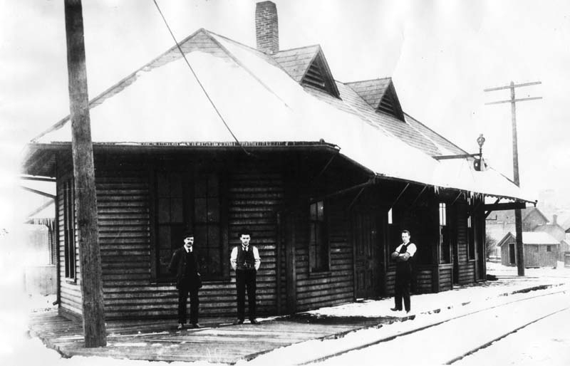
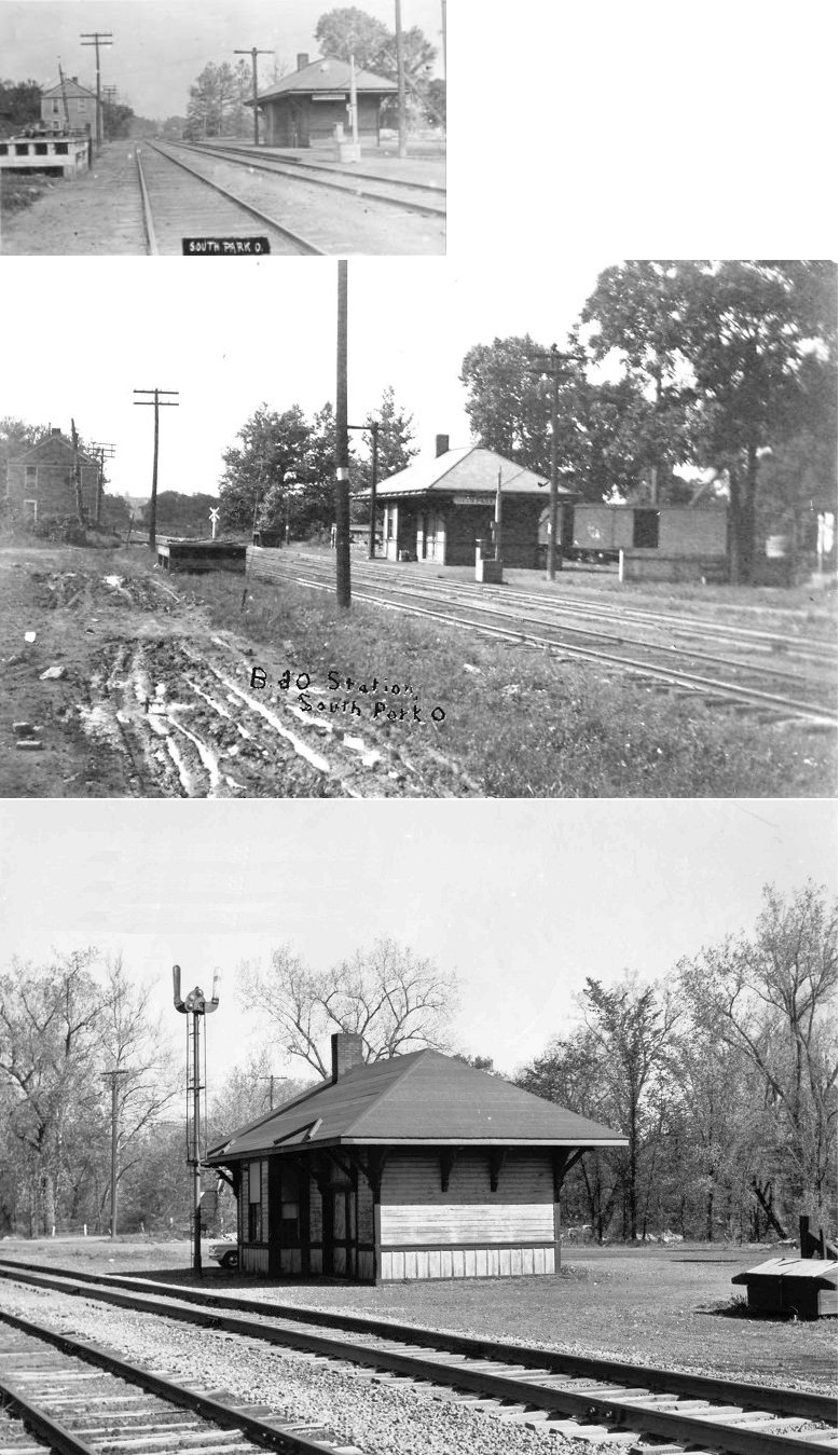
| South
Park (Independence) |
|
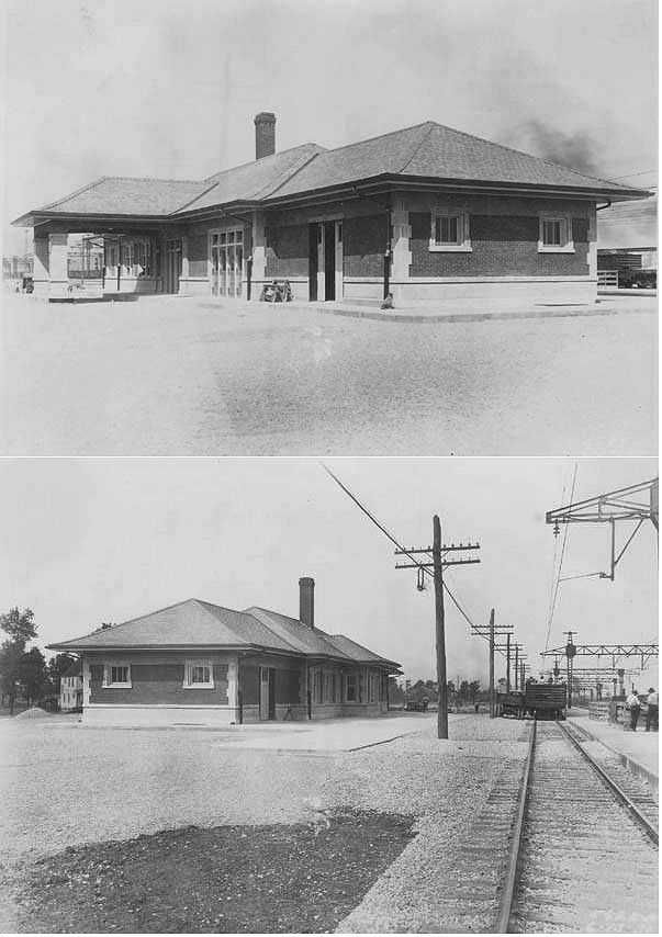
South Park was on the B&O's Cleveland Terminal & Valley Sub-division, about 10 miles south of Cleveland. The B&O station pictured was built in 1905. | ||||||
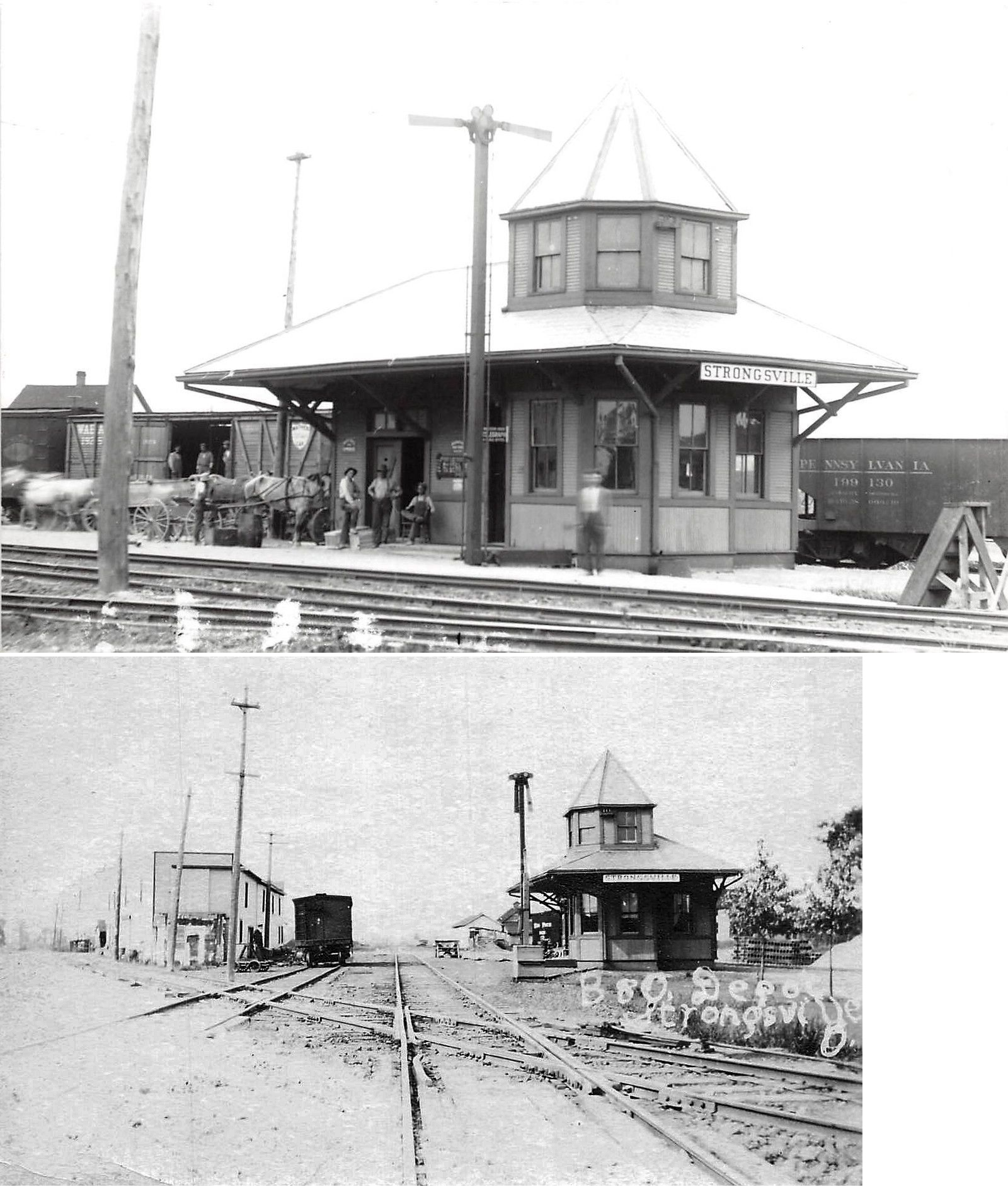
| Strongsville |
|
|||||||
| Summit Station |
|
This flag stop was on the Chagrin Falls Branch between Falls Junction and Chagrin Falls on Arthur Road in the vicinity of GPS: 41.371502, -81.449597. | ||||||
| Tinkers Creek |
(B&O) |
The 1905 timetable shows a stop at Tinkers Creek. This station was near the northern end of what is now Riverview Road in the vicinity of GPS: 41.365448, -81.612875. | ||||||
| Vaughn |
|
|||||||
| Webbs crossing |
Rocky River Railroad |
Webbs Crossing was a station on the Rocky River Railroad before it became part of the NKP. | ||||||
| West Park (Rockport) |
|
This station was on the north side of Lorain Avenue just west of West 143rd Street. It was on the SE side of the tracks at approximately GPS: 41.454440, -81.794372. | ||||||
| West Park |
|
There was a small, 900-square foot freight station here with a two car standing capacity. By 1934 this freight station had been closed. | ||||||
| West View |
|
According to valuation records from 1930, this station was built in 1865. | ||||||
| Whippoorwill |
Rocky River Railroad |
Whippoorwill was a station on the Rocky River Railroad before it became part of the NKP. | ||||||
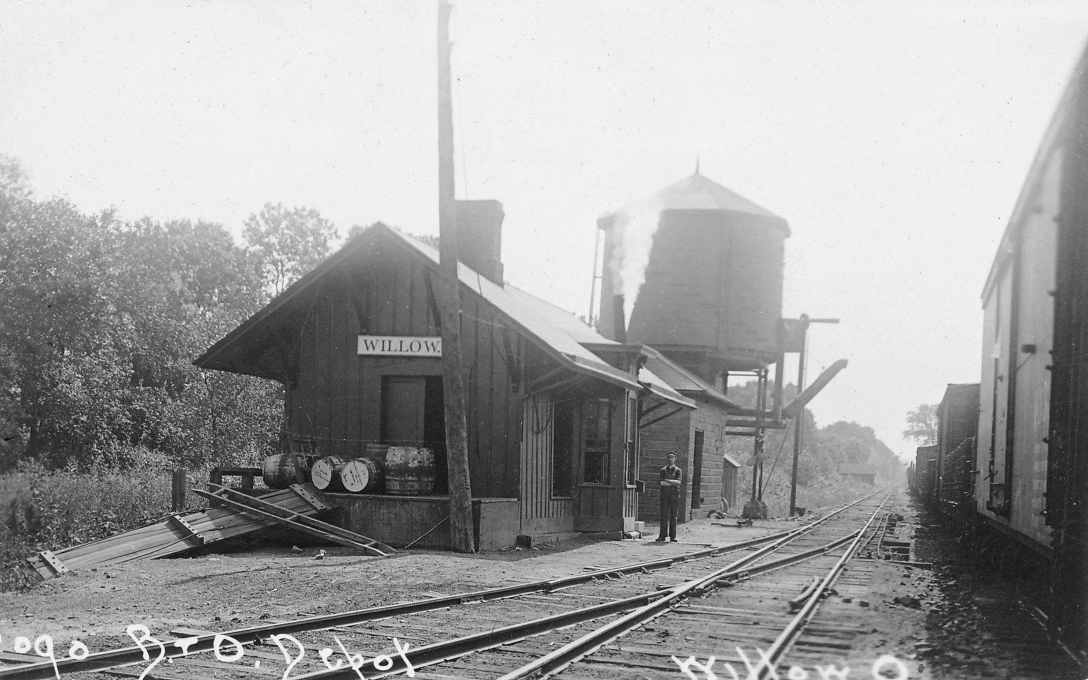
| Willow (Independence) |
|
This location was absorbed into the city of Independence. | ||||||
| Woodland |
(W&LE) |
This pre-W&LE commuter stop was flag-only stop. There was likely never a station building there. It was on Richmond Road in the vicinity of GPS: 41.376891, -81.488842. Not to be confused with with the "Woodland Hills" flag stop that was on East 93rd Street. | ||||||
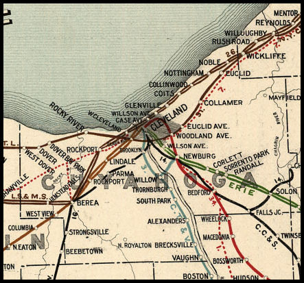
| 1898 CUYAHOGA COUNTY RAILROAD MAP | ||||||||
 |
||||||||
| GOOGLE EARTH MAP OF CUYAHOGA STATIONS |
||||||||
|
Here is a Google Map of Cleveland Area stations past and present by Cards84664: |
||||||||
|
Notes About Existing Stations... Bedford (Connotton Valley) - Restored 1987. Line now leased to Connotton Valley Railroad, which operates the line from Falls Jct. to Weingold Scrap where the line is cut off. Although built by the Connotton Valley Railway, it is restored according to its 1920s W&LE look. Berea (CCC&St.L) - Across from BE Tower On National Register of Historic Places. Sometimes referred to as a "union depot" because it also served the local street railway here. The western end (76-feet) was built in 1899 and the eastern end (20-feet) was added in 1912. The building was sold to the Railway Express Agency in 1956. Berea (B&O) - Station was "Berea" but building actually was in Middleburg Heights. It was moved to Trolleyville, USA around 1971 where is was on display until being moved to Olmsted Falls in late 2008 (Trolleyville previously closed in 2005). Bay Village (NKP) - Moved from trackside to city park. This station is shown as "Dover" or "North Dover" on some older maps. Brecksville (CT&V) - Building was purchased by the operator from Jaite and moved to the current location in 1942. Chagrin Falls (Chagrin Falls & Southern) - Temporarily moved to Geauga County Fairgrounds in Burton. The depot, owned by Claridon Township Trustee Mary Briggs took about 3 1/2 hours to move. She plans to place the depot on a parcel she owns at 14801 Goodwin Ave in Burton Village. The depot is visible from Claridon-Troy Road. The Chagrin Falls and Southern was a private, narrow-gauge line nicknamed "the Silver Plate" and later became part of the Wheeling & Lake Erie, which became part of the Nickel Plate. Cleveland (Union Station) - Terminal Tower was served by the CCC&ST.L, NKP, and LS&MS and Erie (beginning in 1948). Cleveland (Valley Railway) - Later owned by the B&O, closed to passenger traffic in 1934 and then became a freight office. Cleveland (W&LE) - Houses QRS Office Supply. The pitched roof over the back end of the freight house was replaced with a flat roof (see photos). There was another W&LE freight house across Commercial Road which is now gone. Falls Junction (W&LE) - Until 1974, the depot was used by the Wheeling & Lake Erie Railway. In 1993, the W&LE donated it to the Midwest Railway Preservation Society. Glenville (LS&MS) - This was the original Glenville station. It was originally at the end of Foster Avenue on the NW side of the tracks (where the Shoreway is today). It was most likely moved to make way for the Cleveland Shoreway. Olmstead Falls (LS&MS) - Houses CV&WS Model RR Club. PRR Caboose on site. Station is on the NRHP listed with a date built of 1876. Solon (Erie) - Replaced original station which burned. The tracks are actually out of service to the east of the station, but still in service to the west of it--about 50 feet east of the station, there is a piece of rail removed to officially take the line out of service to east. |
||||||||